Weekend Weather Outlook
The start to the first weekend of meteorological summer will be unsettled, with three systems ushering in rounds of rain and thunderstorms that could disrupt outdoor activities.
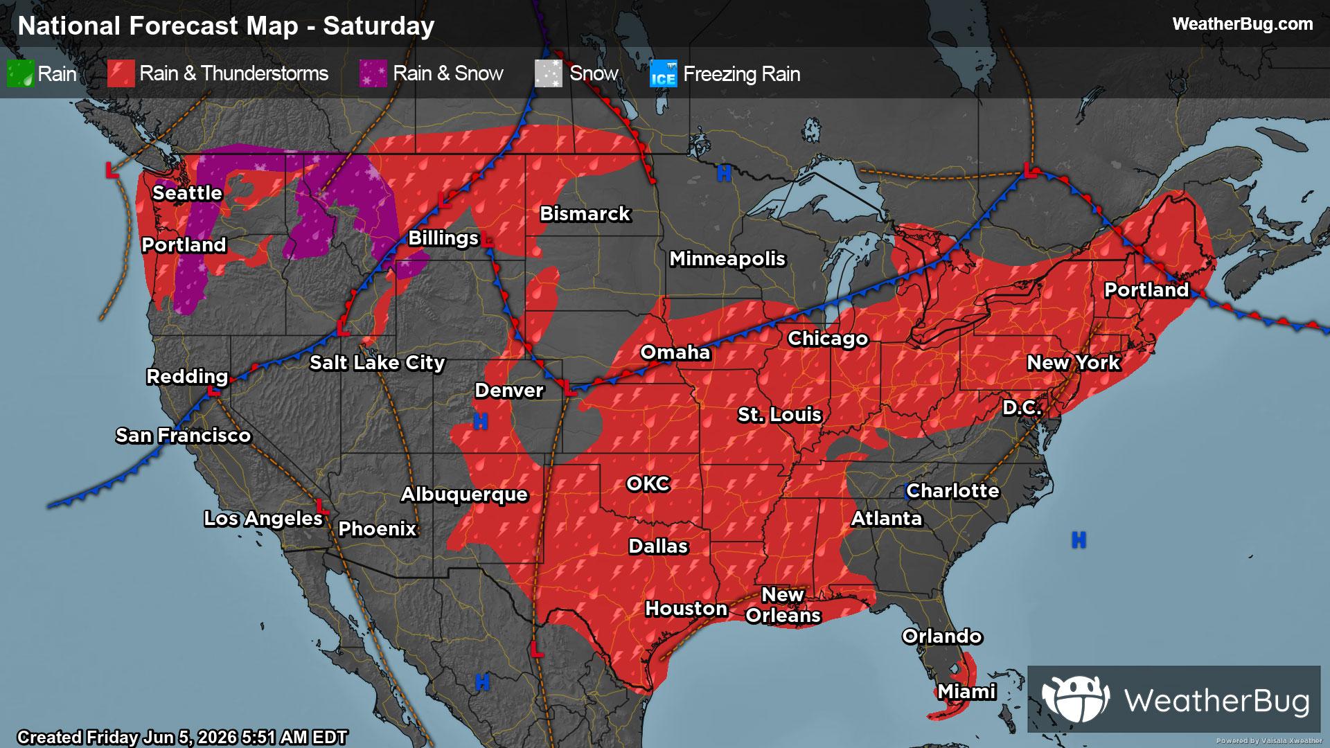
Saturday
One area of low pressure will track from the Great Lakes into the Northeast, dragging a cold front through the Midwest, Mid-Atlantic, and Northeast. Meanwhile, an upper-level disturbance will slide through the south-central U.S., and yet another system pushes into the West with its own cold front. The result will be widespread chances for rain and thunderstorms across much of the nation.
Showers and thunderstorms will be fairly extensive, stretching from the Northeast and Mid-Atlantic through the Lower Midwest, southern Plains, and Mississippi Valley, and extending into the Rockies and Northwest. While activity is possible at any point, the most numerous storms are anticipated during the afternoon and evening hours. In the higher elevations of the northern Cascades, temperatures may dip low enough for some wet snow or a rain/snow mix.
Two regions will be on the lookout for stronger storms. The first runs from the Ohio Valley into the Northeast, while the second covers the northern High Plains. In both areas, damaging winds and large hail will be the primary concerns. A few gusty thunderstorms are also possible across the southern Plains.
Heavy rainfall will be another concern, particularly from the Ohio River Valley into the south-central U.S. Widespread totals of 1 to 3 inches are likely, with isolated higher amounts possible. Given already saturated soils in some locations, flooding issues could develop, specially near rivers, streams, and in urban or low-lying areas. If you do approach a flooded roadway, remember that it is always best to “Turn Around, Don’t Drown!”
Despite the considerable active weather, a few regions will stay dry to start the weekend. This will include much of the Southeast, the Upper Midwest, and areas from the Great Basin into California and the Desert Southwest.
Sunday
All three systems from Saturday will remain active on Sunday. The low in the Northeast will gradually lift toward Atlantic Canada, while the disturbance over the central U.S. will track northeast into the Lower Midwest. Meanwhile, the larger system and its cold front in the West will continue pushing east, spreading into the Rockies and High Plains.
Much like Saturday, rain and thunderstorms will remain widespread to wrap up the weekend. Activity will stretch from the Northeast and Mid-Atlantic through the Lower Midwest, across much of the Plains and Mississippi Valley, and into the Rockies. A few spotty showers will also be possible along the U.S. and Canada border in northern Washington and northern Idaho. While showers and storms could develop at any time, the most active period will once again favor the afternoon and evening hours.
Severe weather and heavy downpours will be possible again on Sunday, focused mainly across the Plains and Mississippi Valley. The primary threats will be damaging winds, large hail, and pockets of localized flooding, though an isolated tornado or two cannot be ruled out.
Aside from a few isolated showers or storms in southern Florida, most of the Southeast will stay largely dry on Sunday. The Great Lakes and much of the region west of the Rockies will also see a relatively quiet finish to the weekend.