Back to forecast
Thanksgiving Travel Outlook: Northeastern Travelers Will See Some Trouble
November 28, 2024 at 03:30 AM EST
By WeatherBug's Alyssa Robinette and Keegan Miller
Thanksgiving Day is here, and although most of the nation can expect dry, timely visitors at their doorstep, some hosts in the Eastern U.S. may need their doormats on standby while delayed relatives rush in for what's left of the feast.
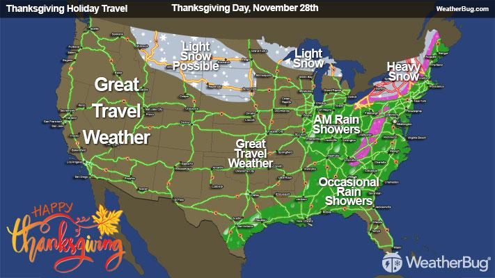
Thanksgiving Day
The day we all go to see family and friends across the nation will widely involve pleasant weather in the Western and Central U.S., but some locales will still see risks.
Flurries to light snow showers are expected in the interior Northwest. A deep arctic blast is expected to enter through the day in the northcentral Plains; however, it is affecting drivers in the region.
Northcentral U.S. travel impacts include:
Western Great Lakes travel impacts include:
A more dreary Turkey Day is in store for the Eastern U.S. as a low pressure system in the South revolves northeastward as the day progresses. Successive cold fronts and a strong warm front are poised to drench the Mississippi and Tennessee Valleys in the morning, sweeping moderate to heavy showers and a few thunderstorms into the Southeastern states by nighttime. Some freezes could accompany the valleys into the nighttime as an arctic blast begins to penetrate from the northern Plains.
Deep South and Valley travel impacts include:
The Northeast's coastal lowlands instead expect semi-persistent rainfall through the day. Most showers south of Maryland will exit the fray by the afternoon, but some cold front rain and isolated thunderstorms could plague parts of the far Southeastern coastline in and through in the afternoon hours.
East Coast travel impacts include:
Thanksgiving Day
The day we all go to see family and friends across the nation will widely involve pleasant weather in the Western and Central U.S., but some locales will still see risks.
Flurries to light snow showers are expected in the interior Northwest. A deep arctic blast is expected to enter through the day in the northcentral Plains; however, it is affecting drivers in the region.
Northcentral U.S. travel impacts include:
- Some slick, iced portions of roadway possible along highways such as Interstates 94 and 90 along with increased hypothermia risk from longer outside exposures.
Western Great Lakes travel impacts include:
- Variable snow accretion leading to slippery roadways along the most northern stretch of Interstate 75, U.S. Routes 2, 31, 141, and 31, and state routes such as Michigan's 22, 72, and 28.
A more dreary Turkey Day is in store for the Eastern U.S. as a low pressure system in the South revolves northeastward as the day progresses. Successive cold fronts and a strong warm front are poised to drench the Mississippi and Tennessee Valleys in the morning, sweeping moderate to heavy showers and a few thunderstorms into the Southeastern states by nighttime. Some freezes could accompany the valleys into the nighttime as an arctic blast begins to penetrate from the northern Plains.
Deep South and Valley travel impacts include:
- Wet roads possible through Thanksgiving along Interstates 69, 40, 75, 20, 59, 22, and 55.
- Late night black ice and slick roadways possible along Interstate 69.
- Minor morning and early afternoon airport delays are possible in cities such as Nashville and Memphis, Tenn., and Birmingham, Ala. from low visibility under rainfall.
The Northeast's coastal lowlands instead expect semi-persistent rainfall through the day. Most showers south of Maryland will exit the fray by the afternoon, but some cold front rain and isolated thunderstorms could plague parts of the far Southeastern coastline in and through in the afternoon hours.
East Coast travel impacts include:
- Wet roadways through the day along major interstates such as 85, 81, 95, 64, 70, 76, 84, and 90.
- Snow cover and slick roadways likely on western portions of Interstates 70, 76, 80, 86, 90, and 81,.
- Minor morning or afternoon delays in airports possible, including in Washington D.C., Baltimore, Philadelphia, New York City, Buffalo, and Boston.