
2025 Year in Review: Extreme Weather - July Through December

Mother Nature did not let up for the second half of the year, with no shortage of extreme weather. The last six months of the year was filled with deadly flooding, dangerous thunderstorms, earthquakes and even a typhoon!
July: Central Texas Floods
A trough of low pressure settled over the Southwest on July 3rd, which combined with remnant moisture from Tropical Storm Barry. There was also a high-pressure system over the Gulf. Southeasterly winds associated with this area of high pressure funneled moisture into the south-central U.S. Both sources of moisture combined over central Texas, bringing rounds of heavy to very heavy rain and significant flooding between July 4-7.
The unique geology of the Texas Hill Country amplified the flood’s intensity as impermeable limestone limits filtration and causes rainfall to run-off almost immediately. Combined with the region’s topography, this fast-draining landscape funnels water down steep hillsides and into creeks at alarming velocities. To make matters worse, the region was already strained by prolonged drought, which caused hardened soil and reduced vegetation. All these factors combined to create the “perfect storm.”
Flooding began on the morning of July 4th after the heavy to very heavy rain caused the Guadalupe River to rise significantly. The river crested at 37.5 feet in just a few hours, which is nearly 20 feet higher than its major flood threshold! Most counties recorded more than 10 inches during this multi-day event, with some spots seeing more than 20 inches of rain.
Summer camps, RV parks and campgrounds along the river were packed with campers, children and staff who had little time to react to sudden flooding in the middle of the night. The most heavily impacted was Camp Mystic, built along the banks of the Guadalupe River, much of it within a FEMA designated floodway. In total, at least 137 people were killed from these floods, with 27 of those in the camp along the river. Around $1.1 billion in damage was reported, with over 12,000 structures affected. It is one of the deadliest flood events in Texas history, and the deadliest inland flooding event in the U.S. since the 1976 Big Thompson River flood, surpassing flooding from Hurricane Helene in 2024.
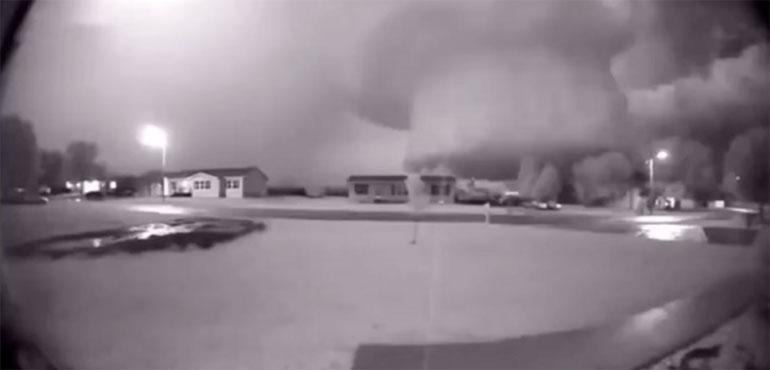
August: Southwest U.S. Haboob
A monsoon is a seasonal wind shift that brings big changes in the weather, usually wet summers and/or dry winter. The Southwestern U.S. has a monsoon pattern during the mid to late summer that results in lots of rain and thunderstorms. During the early afternoon, a classic monsoon setup was in place. Showers and thunderstorms started to develop and merge southeast of Phoenix. As these storms moved northwest, strong winds associated with the storms formed a massive wall of dust, which is also known as a haboob. It also had heavy rain and significant flash flooding.
Several cities were impacted by this haboob, including Phoenix, Arizona City, Casa Grande, Tucson, Ariz. Even parts of the Baja Peninsula and Imperial County, Calif., felt the effects. Visibility was less one-quarter mile in these spots, and the dust storm was even enough to block out nearly all sunlight, making it eerily seem like nighttime. Widespread wind gusts of 50 to 65 mph were reported. Power poles were knocked over, while semi-trucks flipper over on I-8 near Tacna, Ariz., and California Highway 86 in Imperial County.
After the winds and dust storms, rain intensified over the next few hours. Rainfall total ranged from as much as 2 to 3 inches in spots. Tacna, Ariz., also reported 1.9 inches of rain in an hour, which is about half of the yearly average. Significant flash flooding occurred, especially across Imperial County in southeastern California. There were numerous reports of overflowing washes that resulted in road closures and stranded vehicles, requiring numerous water rescues.
September: Cebu Earthquake
September went out with a bang as a powerful earthquake struck the Visayas archipelago in the Philippines. This earthquake struck in the evening of September 30 and was a 6.9 magnitude earthquake. The epicenter was located about 8 miles off the eastern coast of Daanbantayan in Cebu Province, Central Visayas. Though, it was felt across the entire Visayas region, parts of Luzon and Mindanao.
Tectonic plates are always slowly moving, but they get stuck at their edges due to friction. When the stress on the edge overcomes friction, there is an earthquake that releases energy in waves that travel through the Earth’s crust and causes shaking. This is called a tectonic earthquake, which caused the 2025 Cebu Earthquake. This earthquake occurred at a shallow depth of about 3 miles, which contributed to the strength of the shaking felt across a wide area.
According to the Philippine Institute of Volcanology and Seismology (PHIVOLCS), the quake was caused by an offshore fault near the epicenter that had been dormant for over 400 years. It was not previously named and was rarely detected due to its underwater location. After this earthquake, this fault was named the Bogo Bay Fault.
Within 48 hours following the earthquake, PHIVOLCS recorded over 7,000 aftershocks, the strongest of which measured 4.9 magnitude. Following the quake, the PHIVOLCS issued a tsunami advisory following the earthquake, warning of possible minor sea-level disturbances in coastal areas and was later lifted after conditions subsided.
More than 750,000 people were affected by this earthquake just across the Central and Eastern Visayas alone. Additionally, more than 185,000 homes were damaged, of which more than 10,500 were destroyed. Twenty-seven power stations failed, which resulted in power outages that affected more than 819,000 consumers across 309 municipalities. At least 79 people were killed by the earthquake, making it the deadliest earthquake in the country since 2013. There were also 1,271 injuries. Damage was estimated to be around $61 million (U.S. Dollar).
October: Typhoon Halong
Typhoon Halong was a strong typhoon that formed in the eastern Pacific on October 6, 2025. It strengthened dramatically and became comparable to a Category 4 hurricane on the Saffir-Simpson scale the same day it became a typhoon. It passed near to Japan at its peak intensity as part of its turn to the northeast. Halong became an extratropical cyclone on October 10, 2025, before it spread heavy rain and strong winds to the Aleutian Islands.
Some major impacts from Halong included widespread damage to the Yukon-Kuskokwin Delta in Alaska, where wind gusts were as strong as 107 mph. The island of Hachijojima in Japan was particularly hard it. Here, rainfall amounts up to 13.7 inches fell, over 2,7000 customers lost power, 2,200 lost water and roads were impassible. Homes were destroyed and one fatality were recorded in Kwigilingok, Alaska.
November: Southern California Flooding
A series of storms, including some that are considered to be part of an atmospheric river, impacted southern California in mid- to late November. An atmospheric river is a long, narrow corridor of abundant moisture in the atmosphere. This phenomenon is often observed along the West Coast of North America, especially during the winter. The proximity of mountains close to the coast helps to squeeze the moisture out of these atmospheric rivers in the form of mountain snow and low-elevation rain.
On one hand, a steady, significant and long-lasting rain fell across the region that was beneficial, both in the long and short term, for drought relief. On the other hand, the area saw nearly four times their monthly average in a manner of days, leading to flooded streets, overflowed drainage systems and flooded roadways to places like Huntington Beach and other coastal communities. Other issues that occurred associated with this heavy rain were evacuation warnings for areas that were in the burn scar of wildfires. Vehicles were swept off flooded roadways and fatalities were suffered due to flooding and storm conditions during the event. At one point, over 22 million residents were under flood alerts.
December: Northwest Atmospheric Rivers
December saw a very wet month for much of the Pacific Northwest and northern California. At least two atmospheric river events caused days of rainfall, some of it heavy and causing flooding. At least one fatality was observed in Washington due to flooding and emergency evacuations due to storm-driven flash floods and levee failures. National Guard deployments and emergency declarations in the Seattle suburbs as these communities were threatened by disaster.
Damage to infrastructure from flooding caused disruptions in the shipping industry as well travel to the numerous local, state and national parks located nearby. Some bridges and access roads were damaged, leading to impossible travel in some areas. Even at the time this was written, another atmospheric river had eyes on the Pacific Northwest causing additional headaches for the region.