White Christmas Outlook: Looking Good For The West, N. Tier
We are just days away from Santa making his grand arrival. As we get closer, you may be curious if you will have a White Christmas. Unseasonably warm temperatures greet Santa this week, which limits snowfall. Still, a few places will wake up to a White Christmas.
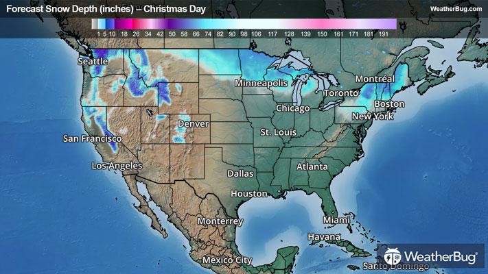
The National Weather Service defines a “White Christmas” as having an inch or more of snow on the ground on Christmas morning.
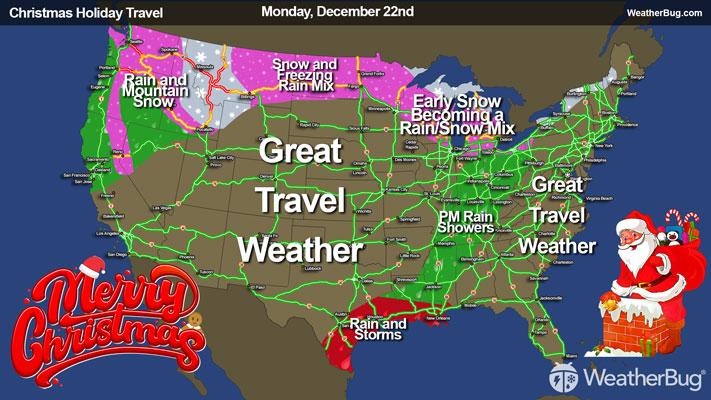
Leading up to Christmas Day, there will be plenty of active weather across the Western U.S. as well as the Northern Tier. However, unseasonably mild temperatures will plague most of the U.S. Consequently, snow will generally be limited to the mountains and higher elevations and areas farther north close to the U.S.-Canada border.
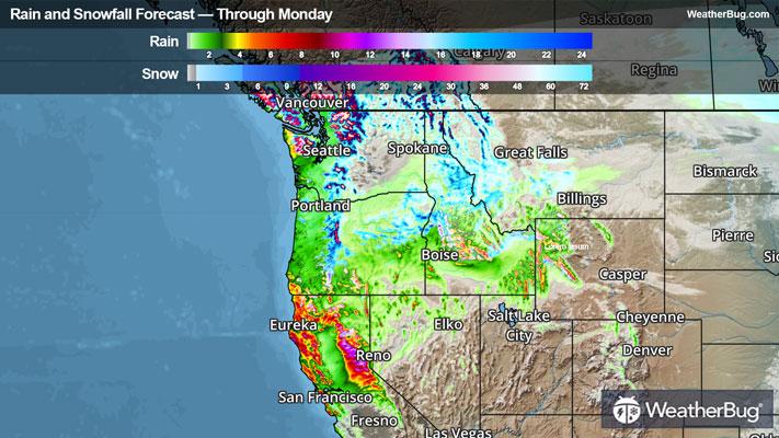
An upper-level weather system will be nearly stationary off the West Coast over the next several days, which will funnel plenty of moisture into areas along and west of the Rocky Mountains. Through Tuesday, the Northwest, northern California and the northern Rockies will see the best chance of rain and mountain snow. This shifts south on Christmas Eve into early Christmas Day, putting California, the Great Basin and the entire Rockies in a better position.
The Klamath Mountains and the Sierra Nevada in California and the tallest portions of the Rockies in central Idaho, northwestern Montana and northwestern Wyoming will see the most snowfall on Christmas morning. Here, snowfall totals will add up to 2 to 4 feet or more! The northern Cascades and Olympic Mountains will also be big winners, with 1 to 2 feet of fresh powder.
By Christmas morning, northeastern Washington State, the southern Cascades and Blue Mountains in Oregon, the Toquima Range in Nevada, the Wasatch Mountains in Utah and the rest of the Rocky Mountains in Idaho, western Montana, south-central Wyoming and western Wyoming will likely see 6 to 12 inches. A White Christmas will be hit-or-miss across the rest of the Mountain West as snow will be dependent on elevation.
Meanwhile, a fast-moving weather disturbance zips across the north-central U.S. on Monday. This will bring a slight chance of snow, freezing rain and rain. As colder air moves in though, this will transition over to all snow by the time it moves into the Upper Mississippi Valley.
The Great Lakes will see a warm front lift across the region for most of Monday, then the same disturbance in the northern Plains will dart through the Upper Great Lakes late Monday into Tuesday. Initially, there will likely be light to moderate snow throughout the Great Lakes on Monday, which would then mix with and change over to rain briefly for the Lower Great Lakes. Snow will continue for the Upper Great Lakes for the rest of Monday into Tuesday.
Despite the wintry mess, much of the northern Plains, Upper Mississippi and Upper Great Lakes already have snow on the ground from earlier this month. There should generally be up to an inch or two of new snow from this system on top of snow that has already fallen. The best chance of a White Christmas will be northeastern Montana, northern North Dakota, northern Minnesota, northern Wisconsin, Michigan’s Upper Peninsula and the northern parts of the Lower Peninsula.
Farther east, the northern Appalachians already have plenty of snow on the ground, but there will also be two chances of snow for the Northeast before Christmas Day. The first will be late Monday into Tuesday, with the second arriving with Santa late Christmas Eve into early Christmas Day. New snowfall of 2 to 4 inches could fall over the higher elevations, with up to 2 inches possible for the rest of the Northeast.
The Pocono Mountains and northern portions of the Allegheny Mountains in Pennsylvania, the Adirondack Mountains in New York and the White and Green Mountains in northern New England will also likely wake up to a White Christmas. Chances will drop farther south, so anyone in southern New England or the Mid-Atlantic will have to travel north if they want to have a White Christmas.
Given the mild, above normal temperatures elsewhere, snow will just be a figment of your imagination, and you will be left to only dream of a White Christmas.
Check back frequently to WeatherBug for the latest on your chances for a White Christmas this week. From all of us at WeatherBug, Happy Holidays!