2025 Year in Review: Powerful Hurricanes in the Atlantic

The U.S. may have been spared from major impacts, but other areas were not so lucky, in particular Jamaica which took a direct hit from Category 5 Melissa.
Tropical Storm Barry
Tropical Storm Barry was the first tropical system of the 2025 season to bring impacts to major land areas. A broad area of low pressure began to form over the Yucatan Peninsula on June 27 and eventually emerged over the southern Bay of Campeche on June 28. With warm waters and lighter wind shear, the low pressure system gradually organized into Tropical Depression Two later that afternoon.
The depression continued to move westward and eventually became a tropical storm on the morning of June 29 about 90 miles east-southeast of Tuxpan, Mexico. Now moving on a northwesterly course, Barry moved into a harsh environment prior to making landfall south of Tampico, Mexico, later in the evening. As a result of the stronger wind shear, the highest sustained winds only reached 45 mph prior to landfall. Barry quickly dissipated on June 30 over northeastern Mexico.
Barry was responsible for at least 8 fatalities and causing US$32.5 million in damages. Rainfall totals of 10 to 15 inches were reported throughout eastern Mexico, with the highest amount of 17.99 inches of rain being recorded in San Gabriel, Tamaulipas, Mexico. Major flooding from the remnants of Barry occurred across the central Texas Hill Country on July 4-5.
Tropical Storm Chantal
Tropical Storm Chantal was the only tropical system in the 2025 season to directly impact the United States. Chantal began life as a broad area of low pressure along a decaying frontal boundary west of Florida on June 29. By the morning of July 4, this low was now located off the Southeast U.S. coastline as was beginning to gain strength, acquiring the designation Tropical Depression Three during the afternoon. Further intensification occurred early on July 5, and the depression was upgraded to Tropical Storm Chantal as the system lingered off the coast.
By the early morning on July 6, Chantal reached its peak intensity when sustained winds reached 60 mph. Chantal made landfall near Litchfield Beach, S.C., a few hours later with maximum sustained winds near 50 mph. By late morning on July 6, Chantal was downgraded to a tropical depression and eventually degenerated into a remnant low over northern Virginia later in the morning on July 7.
Damage caused by Tropical Storm Chantal was estimated to be approximately $500 million. Widespread rainfall totals of 4 to 8 inches occurred across the eastern Carolinas, with as much as 11 inches of rain falling in parts of North Carolina. In addition to the heavy rain and flooding, several tornadoes were reported across North Carolina. This included an EF-1 tornado that caused damage to two hangars and two aircraft at the Raleigh Executive Jetport and caused US$2 million damage in total.
Hurricane Erin
Hurricane Erin was the fifth named storm, first hurricane, and first major hurricane of the 2025 season. It was a long-lived storm that began its life as a tropical wave in the far eastern Atlantic Ocean. Convection quickly increased, and by the morning of August 11, Tropical Storm Erin had formed. Erin traveled briskly across the open waters of the Atlantic, battling dry air and poor environmental conditions for several days. However, by August 15, Erin was able to strengthen into a hurricane as environmental conditions started to become more favorable.
Erin underwent explosive intensification on August 16 and became the season’s first major hurricane. Erin reached its peak intensity later that day when maximum sustained winds reached 160 mph and the central pressure dropped to 915 millibars. Erin then gradually weakened over the next couple of days as it passed to east of the Bahamas. Erin made its closest approach to the Outer Banks of North Carolina on August 21, passing approximately 200 miles to the southeast. Wind shear and colder ocean waters gradually caused Erin to become an extratropical cyclone by August 28.
Erin first impacted the Cabo Verde islands with flooding rainfall. Rainfall totals of 7.57 inches were reported in just five hours on Sao Vicente. At least nine deaths were attributed to the resulting flooding. Erin also caused flooding across parts of Puerto Rico, Grand Turk, and throughout the Bahamas. Major flooding occurred across several locations along the Outer Banks of North Carolina and Virginia, with minor flooding occurring from Maryland to Maine as Erin passed by to the east.
Hurricane Gabrielle
The Atlantic’s seventh named storm, Hurricane Gabrielle, formed as a tropical storm on September 17 in the far eastern Atlantic from a tropical wave from western Africa. Gabrielle struggled to strengthen at first, interacting with dry air and plenty of wind shear, but later became better organized by September 20. Gabrielle strengthened into a Category 1 hurricane on September 21 and later a Category 3 storm by September 22. Gabrielle was not finished strengthening and became a Category 4 storm later that same day, about 180 miles east-southeast of Bermuda. Gabrielle would then turn east-northeast and avoid making landfall in Bermuda, later weakening due to cooler waters and increasing wind shear. By September 25, Gabrielle was back to a Category 1 and neared the Azores as a tropical storm on September 26.
Despite Gabrielle not affecting Bermuda directly, high swells associated with the storm affected the island as well as far west as the East Coast of the U.S., causing rip currents and rough waters. In the Azores, peak wind gusts of 115 mph and peak sustained winds of 78 mph were reported. Waves grew to 33 to 59 feet tall as well. As a result, structural damage occurred, including collapses and roofs and plenty of fallen trees. Sixteen people on the islands were displaced. While a post-tropical storm at this point, Gabrielle also brought strong winds and rain to the Iberian Peninsula, causing severe flooding on Ibiza. Additional flooding also occurred in Marche and Sicily, causing damaged homes. In addition, one person was reported missing here. In total, US$11.7 million in damages occurred.
Hurricane Humberto
Another tropical wave from western Africa resulted in Tropical Storm Humberto on September 24, which formed about 605 miles east-northeast of the Leeward Islands. Humberto would bobble in intensity before later strengthening to a Category 1 storm by September 26 thanks to a favorable environment, including moderate wind shear, warm waters and a moist environment. Humberto would then rapidly intensify further, becoming a Category 5 storm on September 27 and later in the day would reach peak intensity with maximum sustained winds of 160 mph. Humberto would remain a strong hurricane as it turned to the north-northwest on September 29, weakening to a Category 3 storm as it encountered cooler sea waters. By the 30th, Humberto weakened even further to a Category 1 storm and eventually dissipating as the calendar switched to October.
Despite the peak Category 5 strength, Hurricane Humberto had minimal impacts to society. Bermuda saw 2 inches of rain associated with Humberto as well as peak wind gusts of 41 mph and some coastal flooding. The East Coast of the U.S. also experienced high surf associated with Humberto.
Hurricane Imelda
Hurricane Imelda developed from a tropical wave near Cuba and the Bahamas on September 27, and quickly organized into Tropical Storm Imelda later that day. Initially, forecasts suggested a potential threat to the U.S. East Coast, but as Imelda tracked northward through the Bahamas, it interacted with nearby Hurricane Humberto. This interaction altered steering currents, forcing Imelda eastward and away from the U.S. coastline. The storm intensified into a Category 1 hurricane by September 30 and reached its peak at Category 2 strength on October 1 with sustained winds of 100 mph and a central pressure of 966 mb. Imelda passed near Bermuda with hurricane-force conditions before transitioning into a powerful extratropical cyclone on October 2.
Imelda’s impacts were most severe in the eastern Caribbean and Bermuda. Heavy rainfall in Puerto Rico, Cuba, and the Dominican Republic caused widespread flooding and at least four fatalities before the system became a hurricane. In total, Imelda resulted in five deaths, two injuries, and one missing person. Damage estimates exceeded US$10 million, including losses to agriculture and rural infrastructure, as flooding inundated farmland and disrupted crop production in Cuba and the Bahamas. Bermuda endured strong winds, coastal flooding, and crop damage.
Hurricane Melissa
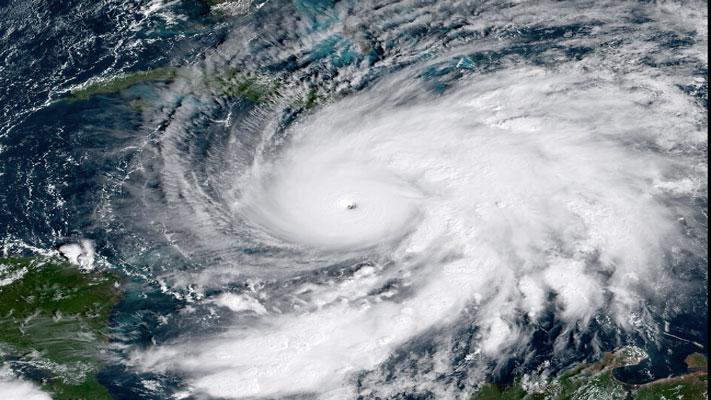
Hurricane Melissa formed from a tropical wave off West Africa in mid‑October 2025 and became Tropical Storm Melissa on October 21 as it entered the Caribbean Sea. Moving over abnormally warm waters, the storm rapidly intensified and reached Category 5 strength by October 28, with peak sustained winds of 185 mph and a central pressure of 892 mb, tying for the third‑lowest on record in the Atlantic. Melissa made a catastrophic landfall near New Hope, Jamaica, unleashing torrential rainfall of 18 to 24 inches across central and southern Jamaica and as much as 36 inches offshore, along with forest‑leveling gusts and severe storm surge. After crossing Jamaica, the hurricane weakened but struck eastern Cuba as a Category 3 on October 29, clipped the Bahamas, passed near Bermuda as a Category 2, and transitioned to a hurricane‑force extratropical cyclone northeast of the island on October 31.
The impacts were devastating. In Jamaica alone, Melissa caused at least 102 fatalities, 141 injuries, and displaced nearly 730,000 people, while more than 500,000 homes lost electricity. Agricultural losses reached about 29.5 billion JMD (US $190 million), destroying key crops such as vegetables, bananas, tubers, and fruit trees, and killing over 1.25 million livestock. Including housing, infrastructure, and economic losses in Cuba, Haiti, the Bahamas, and Bermuda, total damages were estimated at US $48 to 52 billion, making Melissa one of the costliest hurricanes in Caribbean history.

