
Dangerous Spring Storms Take Aim at Ohio Valley, Mid-Atlantic
Spring is here and Mother Nature is set to bring dangerous thunderstorms to parts of the Great Lakes, Ohio Valley and Mid-Atlantic. Large hail will be the primary concern within thunderstorms today.
A fast-moving weather disturbance and developing low pressure system will move from the Great Lakes into the Northeast and Mid-Atlantic today. There will also be an associated cold front that drops south through the region through Monday. Warm, humid air will be in place ahead of the front, while colder and drier air will try to filter in behind it. This collision of air masses will be the catalyst for thunderstorms in the afternoon and evening.
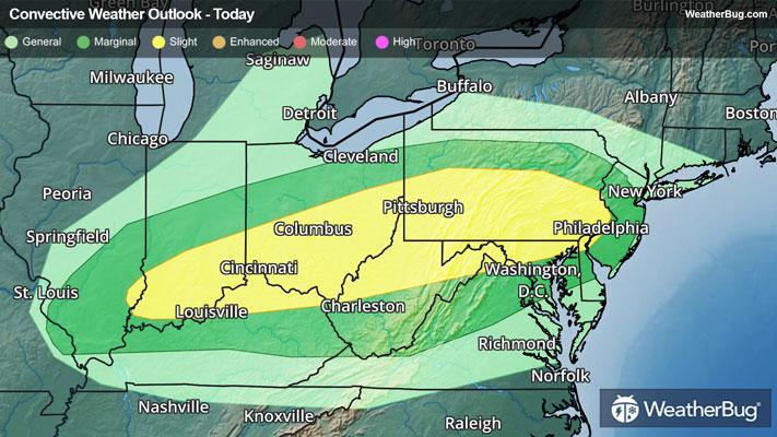
The government’s Storm Prediction Center has issued a Slight Risk (a 2 out of 5 on the storm severity scale) from the Ohio Valley into the northern Mid-Atlantic. This covers Louisville, Ky., Cincinnati and Columbus, Ohio, Pittsburgh and Philadelphia. A larger Marginal Risk (a 1 out of 5 on the storm severity scale) surrounds this Slight Risk from southern Illinois into New Jersey.
A line or a broken line of strong to severe thunderstorms will form across the southern half of Ohio into Pennsylvania this afternoon. These storms will then push south and east into West Virginia, northern and western Maryland, the Delmarva Peninsula and New Jersey this evening and overnight. Large hail will be the main concern within thunderstorms today, with hail to the size of golf balls. Damaging wind gusts exceeding 60 mph and an isolated brief tornado or two could also occur within thunderstorms.
There could be a second round of rain and thunderstorms that move across the Mid-Atlantic early Monday morning. Some gusty winds and hail are possible within this line.
As if dodging dangerous thunderstorms wasn’t enough, torrential downpours will also be possible today into early Monday morning. A quick 1 to 2 inches of rain could fall within these rounds of thunderstorms. Localized flooding is a possibility, especially near rivers, creeks and streams as well as urban, low-lying and more flood prone areas. If you do approach a flooded roadway, remember it’s always best to “Turn Around, Don’t Drown!”
Make sure to know the difference between a watch and a warning should they be issued. A "watch" means that conditions are favorable for severe weather to occur, and to be on alert for any rapidly changing conditions. A "warning" means that severe weather is imminent, and you should act fast to remain safe.
The best way to remain safe is to stay prepared and informed about your local weather. Have a severe weather kit packed with a battery-operated radio, water, and non-perishable food items. Also, check the WeatherBug app frequently for any updates on today's severe weather. Remember, "When Thunder Roars, Go Indoors!"