
Dangerous Storms Rumble Through Mid-Atlantic
The risk for strong to severe thunderstorms remains elevated this evening across the Mid‑Atlantic, especially along and east of the I‑95 corridor. Damaging wind gusts is the primary threat.
A cold front is pushing eastward through the Mid‑Atlantic this evening. Ahead of this front, warm, humid air has surged northward from the Gulf of Mexico, while much cooler and drier air will rush in behind it. This sharp contrast in air masses, combined with strong winds throughout the atmosphere, is creating an environment favorable for dangerous thunderstorms.
There is currently a line of severe thunderstorms found along the cold front that stretches across the Mid-Atlantic into North Carolinas. This line will advance across the Eastern Seaboard this evening and tonight. The front will finally clear eastern New England and Florida by early Tuesday morning.
A Severe Thunderstorm Watch is in effect for portions of Delaware, central and eastern Maryland, northeast North Carolina, southern New Jersey, and southeast and central Virginia. Cities include Philadelphia, Atlantic City, N.J., Washington, D.C., Baltimore, Dover, Del., Norfolk and Richmond, Va., and Elizabeth City, N.C.
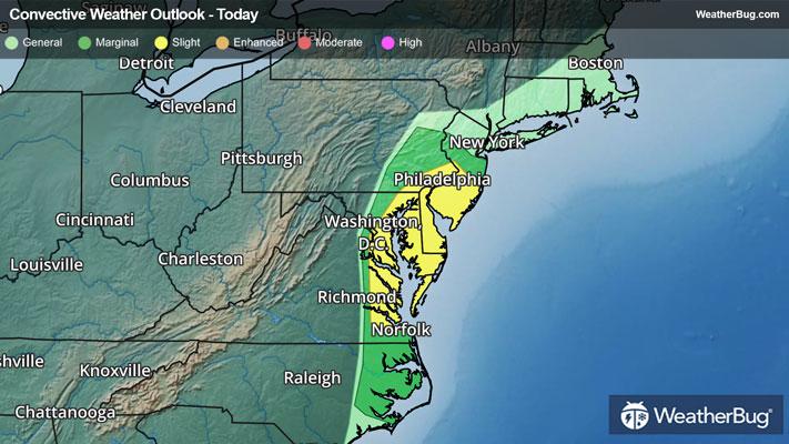
The government’s Storm Prediction Center has issued a Slight Risk (a 2 out of 5 on the storm severity scale) from eastern Pennsylvania southward into southern Virginia. Here, the main concern within thunderstorms will be damaging wind gusts of 60 to 80 mph. Cities included in this Slight Risk include Washington, D.C., Baltimore, Philadelphia, Dover, Del., Arlington and Richmond, Va.
As if dodging dangerous thunderstorms wasn’t enough, heavy, prolonged rain will be likely through tonight, mainly in the Northeast. Totals of 1 to 2 inches will be common from the northern Mid-Atlantic into New England. This heavy, prolonged rain may result in flooding of rivers, creeks and streams as well as in urban, low-lying and other flood prone areas. Remember, if you approach a flooded roadway, it is always best to “Turn Around, Don’t Drown!”
Flood Watches are in effect across Connecticut, Rhode Island, Massachusetts, northeastern New Hampshire and southern Maine.
Make sure to know the difference between a watch and a warning should they be issued. A "watch" means that conditions are favorable for severe weather to occur, and to be on alert for any rapidly changing conditions. A "warning" means that severe weather is imminent, and you should act fast to remain safe.
The best way to remain safe is to stay prepared and informed about your local weather. Have a severe weather kit packed with a battery-operated radio, water, and non-perishable food items. Also, check the WeatherBug app frequently for any updates on today's severe weather. Remember, "When Thunder Roars, Go Indoors!"