Dangerous Thunderstorms Target Southern Plains, Midwest
Another low pressure system tracking across the central U.S. will produce severe thunderstorms today.
Energy aloft, moisture streaming in from the south, and a cold front are the ingredients present to produce very large hail, damaging winds, and even a few tornadoes across the Lower Midwest and southern Plains. These storms will likely start off as supercells and short line segments this afternoon before evolving into a dominant squall line later this evening.
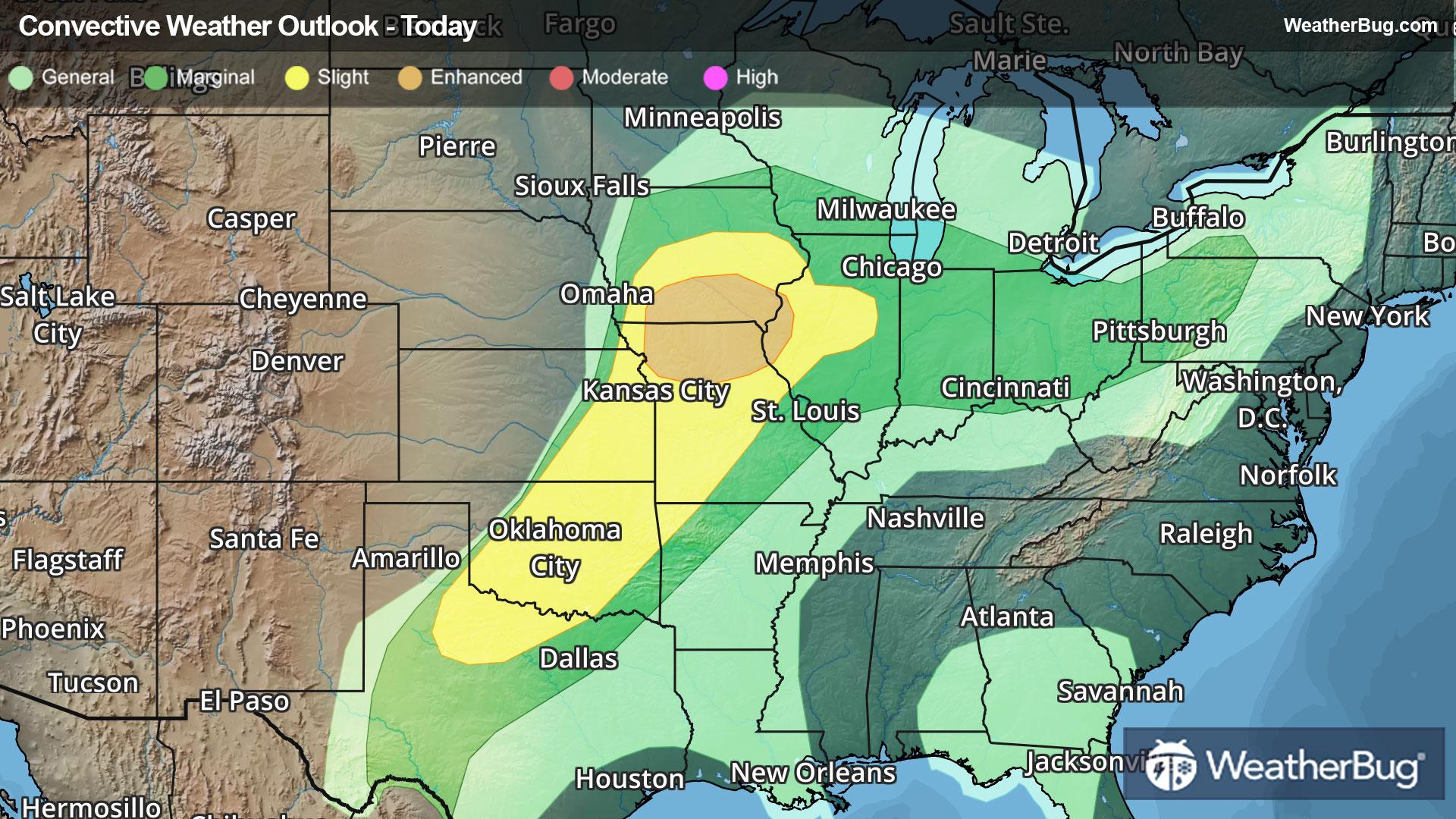
The Storm Prediction Center has overlayed an Enhanced Risk for severe storms (a 3 out of 5 on the severity scale) over northern Missouri, southern Iowa, and part of northwestern Illinois. Towns including St. Joseph and Kirksville, Mo., as well as Ottumwa and Indianola, Iowa, fall under this risk, which encapsulates where more concentrated and intense straight-line winds, hailstorms, and even tornadic severe storms, are likely to appear.
A secondary Slight Risk (a 2 out of 5 on the severity scale) runs from north-central Texas to central Iowa and central Illinois. The cities of Des Moines, Iowa, Wichita, Kan., Kansas City, Mo., and Oklahoma City and Tulsa, Okla., fall under this risk. Widely scattered severe storms that could ignite all modes of severe weather are expected in the region.
A Tornado Watch has been issued for southern Iowa, west-central Illinois, extreme northeastern Kansas, and northern Missouri. This watch includes St. Joseph, Mo., Ottumwa, Iowa, Kirksville, Mo., and Quincy, Ill. The main threats with these storms include a few tornadoes, scattered large hail, and damaging wind gusts up to 65 mph.
A large Severe Thunderstorm Watch has been issued for eastern Kansas, western Missouri, central to northern Oklahoma, and northern Texas. This watch includes Oklahoma City, Kansas City and Joplin, Mo., Topeka and Emporia, Kan., and lastly Tulsa and Ardmore, Okla. Scattered large hail events up to 3 inches in diameter, damaging wind gusts to 70 mph, and a couple tornadoes are the possible threats.
A second Tornado Watch is in effect for central Illinois and west central to northwest Indiana. Cities include Peoria, Ill, and Lafayette, Ind.
This storm system will also bring the threat of flash flooding, as 1 to 4 inches of rain could fall over a relatively short period of time. On Saturday, the Ohio Valley will be under a severe weather threat as the system shifts eastward.
Make sure to know the difference between a watch and a warning should they be issued. A "watch" means that conditions are favorable for severe weather to occur, and to be on alert for any rapidly changing conditions. A "warning" means that severe weather is imminent, and you should act fast to remain safe.
The best way to remain safe is to stay prepared and informed about your local weather. Have a severe weather kit packed with a battery-operated radio, water, and non-perishable food items. Also, check the WeatherBug app frequently for any updates on today's severe weather. Remember, "When Thunder Roars, Go Indoors!"