Back to forecast
Torrential, Flooding Rain Drenches New York State to New England
July 10, 2023 at 09:39 PM EDT
Updated By WeatherBug Meteorologist, Fred Allen

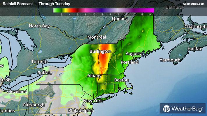
A lumbering storm will continue to soak residents from Upstate and eastern New York to northern and western New England through Tuesday. Dangerous, life-threatening flash flooding is likely to occur in parts of Vermont and far eastern Upstate New York.
A pattern in gridlock will force an area of low pressure with a tropical-like connection to move slowly north across southern and central New England to eastern Canada through Tuesday. This will mean additional, repetitive waves of rain and even thunderstorms will add to the already drenched region during this time.
Particularly hard hit so far today has been eastern New York and western Massachusetts into much of Vermont. One to 4 inches has been commonplace, while there have been many 4 to 8-inch reports along and east of Vermont’s Green Mountains. A weather station near Braintree, Vt., has measured 6.75 inches of rainfall for a storm total so far. Even more impressive totals of 7.31 inches and 7.07 inches have been reported near Windsor and Rutland, Vt., with rain still falling!
Another inch to locally 3 inches or more could fall, particularly across interior Vermont to near the Canada and New Hampshire-Vermont border. These storm totals will exacerbate ongoing urban and flash flooding, as well as cause rivers, streams, and creeks to continue to rise due to excess runoff. This could lead to life-threatening flooding in some instances, especially in far eastern Upstate New York and east of the White Mountains in Vermont.
Flood Watches, Flood Warnings, Flood Advisories, and Flash Flood Warnings remain in place until Tuesday from much of central and eastern New York to northern Connecticut, Rhode Island, and central Massachusetts northward to the Canada-New Hampshire-Vermont-southwestern Maine border. If you approach a flooded road, remember the motto “Turn Around, Don’t Drown!” Albany, N.Y., Hartford, Conn., Worcester, Mass., Providence, R.I., Burlington, Vt., and Concord, N.H., are just a few cities found in this elevated flood danger zone.
This same weather maker delivered catastrophic flooding to the Lower Hudson Valley to conclude the weekend. Stormville, N.Y., in Dutchess County, was soaked by 8.61 inches of rain, as Hopewell Junction, N.Y., wasn’t far behind at 7.01 inches. Many water rescues also occurred, including near Highland Mills, N.Y., where flash flooding led to a fatality after she was swept away by raging flood waters. Metro North near Montrose, N.Y., in Westchester County had to suspend service on the Hudson Line from Croton to Poughkeepsie, N.Y., due to track flooding.