Back to forecast
Hawaii’s Cold Season Flooding Menace: The Kona Low
January 29, 2023 at 03:57 PM EST
By WeatherBug Sr. Meteorologist, Chad Merrill
Hawaii occasionally makes headlines when hurricanes approach during the height of the Pacific tropical season, but a certain type of winter storm can be even more destructive.
The infamous Kona Low is a low pressure that develops during the winter. Kona means “leeward” and refers to a southerly wind that replaces the typical easterly trade winds. When a Kona Low is mentioned in a weather forecast discussion or in the media, Hawaii residents can expect heavy rain, flash flooding, high winds, large waves, hailstorms and severe thunderstorms.
Early detection of the Kona Low includes a stalled low pressure northeast of Hawaii. However, computer model simulations do not accurately forecast Kona Lows because of the smaller scale structure of these systems. The Kona Low can develop within as little as a six mile radius before intensifying and producing impact in Hawaii. The lack of observational data over the Pacific doesn’t allow the forecast models to “see” the Kona Low and thus give forecasters enough lead time to warn residents of their danger days leading up to their impacts.
A 2022 study published in the Monthly Weather Review indicated most of the Kona Lows developed from a dissipating low pressure along a cold front. Only a few Kona low pressure centers developed within an enhanced easterly trade wind and had no connection to a preexisting cold front. The study also indicated most Kona storms occurred in January and La Nina winters are more favorable for their development compared to El Nino winters.
Hawaii has seen several recent examples of Kona storms. A Kona Low developed in late February of 1997 and triggered record wind in Hilo, large hail and even a blizzard to the high elevations. Damage estimates in Hawaii were $7.2-million in today’s currency.
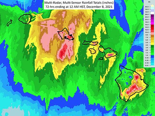
In early December 2021, a strong Kona Low developed northwest of Hawaii and flooded Highway 11 at Kawa Flats in the Kau District. Large trees blew across the road on the Big Island with gusts clocked at 100 to 105 mph. Meanwhile, snow drifts of 3 to 5 feet swept across Mauna Kea.
A Kona Low was responsible for producing gusts of 70 mph on Oahu, closing the road to the summit of Haleakala on Maui and producing 11 inches of rain on the Big Island in early December 2007. Like the December 2021 event, the Kona Low formed north of Hawaii.
The next time you read WeatherBug’s content and spot the term “Kona Low” or hear it mentioned on the news, remember the magnitude of damage and destruction they can cause and brace ahead of time for its impacts.
---
Story Image: Radar estimated rainfall following a Kona Low that impacted Hawaii in early December 2021. (Courtesy of the National Weather Service in Honolulu, Hawaii)
The infamous Kona Low is a low pressure that develops during the winter. Kona means “leeward” and refers to a southerly wind that replaces the typical easterly trade winds. When a Kona Low is mentioned in a weather forecast discussion or in the media, Hawaii residents can expect heavy rain, flash flooding, high winds, large waves, hailstorms and severe thunderstorms.
Early detection of the Kona Low includes a stalled low pressure northeast of Hawaii. However, computer model simulations do not accurately forecast Kona Lows because of the smaller scale structure of these systems. The Kona Low can develop within as little as a six mile radius before intensifying and producing impact in Hawaii. The lack of observational data over the Pacific doesn’t allow the forecast models to “see” the Kona Low and thus give forecasters enough lead time to warn residents of their danger days leading up to their impacts.
A 2022 study published in the Monthly Weather Review indicated most of the Kona Lows developed from a dissipating low pressure along a cold front. Only a few Kona low pressure centers developed within an enhanced easterly trade wind and had no connection to a preexisting cold front. The study also indicated most Kona storms occurred in January and La Nina winters are more favorable for their development compared to El Nino winters.
Hawaii has seen several recent examples of Kona storms. A Kona Low developed in late February of 1997 and triggered record wind in Hilo, large hail and even a blizzard to the high elevations. Damage estimates in Hawaii were $7.2-million in today’s currency.
In early December 2021, a strong Kona Low developed northwest of Hawaii and flooded Highway 11 at Kawa Flats in the Kau District. Large trees blew across the road on the Big Island with gusts clocked at 100 to 105 mph. Meanwhile, snow drifts of 3 to 5 feet swept across Mauna Kea.
A Kona Low was responsible for producing gusts of 70 mph on Oahu, closing the road to the summit of Haleakala on Maui and producing 11 inches of rain on the Big Island in early December 2007. Like the December 2021 event, the Kona Low formed north of Hawaii.
The next time you read WeatherBug’s content and spot the term “Kona Low” or hear it mentioned on the news, remember the magnitude of damage and destruction they can cause and brace ahead of time for its impacts.
---
Story Image: Radar estimated rainfall following a Kona Low that impacted Hawaii in early December 2021. (Courtesy of the National Weather Service in Honolulu, Hawaii)