Back to forecast
Northern Tier Gets Waves Of Snow And Cold
October 30, 2024 at 07:11 AM EDT
Updated By WeatherBug Meteorologist, Fred Allen

A pair of disturbances will bring the first notable snow of the season to parts of the northern U.S. Sub-freezing temperatures will likely bring an end to the growing season across parts of the Rockies and High Plains as well.
A strengthening low pressure system will migrate eastward across the central Plains today. A mix of cold, Canadian air behind it and leftover Pacific moisture will add to the snowfall totals across the tallest peaks across Wyoming and Colorado’s Rocky Front Range.
Winter Storm Warnings and Winter Weather Advisories are in effect from far western South Dakota to Utah’s Wasatch Range and along the Wyoming and Colorado Rocky Front Range. Aspen, Colo., Casper, Gillette, and Sheridan, Wyo., Park City, Utah, and Hill City and Deadwood, S.D., are included within these winter-related zones.
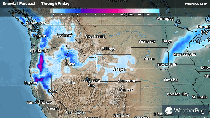
An additional 1 to 4 inches will fall along parts of the Interstate 80 corridor along Utah’s Wasatch Range through this morning. This will bring storm totals near a half foot. Bigger snowfall totals will occur across Wyoming’s Wind River and Bighorn mountains, as well as the San Juan mountains in Colorado. Here, locally 10 to 18 inches of snowfall is forecast by the time the snow ends this afternoon, especially above 8,500 to 9.000 feet.
Further east across South Dakota’s Black Hills, wet snowfall accumulation of 3 to 8 inches is anticipated. This system will also produce snow in parts of the Upper Midwest tonight through Thursday afternoon, with a band of 1 to 5 inches of snow likely in northeastern Minnesota and northwestern Wyoming.
Freeze Warnings are in effect sporadically in the Four Corners and across western Kansas and southern Nebraska for this morning and Thursday morning. Colby and Goodland, Kan., McCook, Neb., Denver, Colorado Springs, and Pueblo, Colo., Clovis and Albuquerque, N.M., and Salt Lake City, Utah, are included.
Another disturbance will begin to move into the Northwest and Great Basin today, generating rain and high elevation snow across those regions through Friday. The higher peaks of Washington, Oregon, northern California, and western Idaho are set to recieve 4 to 12 inches of snow over the next few days, with locally higher amounts of 1 to 3 feet in the Cascades across Oregon and Washington. Winter Storm Warnings and Winter Weather Advisories can be found along the Cascades.
It is never too early to have a supply kit packed in case of winter weather. A simple kit including a weather radio, water, blankets, batteries, and non-perishable food items will go a long way in the event of a power outage. It is always best to avoid travel in rough weather as the roads will be dangerous.