Storm Brings Heavy Midwestern Snow, New England Icing
A major winter storm will thrash the nation's northeastern quadrant with high winds, heavy snow, and significant icing through tonight and beyond.
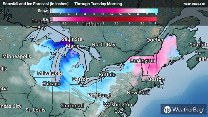
An intense low pressure system is deepening over the Great Lakes today, shifting northeastward into Canada through tonight. To the low’s southeast, a warm front is brushing over sub-freezing air through New England and the Adirondacks, which is resulting in significant ice accumulations in the region that will glaze over roadways, topple power lines, and snap tree branches. Snow and sleet will prelude freezing rain, which in turn will prelude plain rain as the warm front’s air mixes into the surface.
Most areas in this region will see a glaze of up to one-tenth inch of ice accumulation. However, some of the colder spots between the Adirondacks and Maine’s ranges could see anywhere from four-tenths up to seven-tenths inches of ice in total. Some locations expecting these crippling ice accumulations are currently under Ice Storm Warnings, which include parts of the Adirondacks and Vermont’s Green Mountains.
Snow accumulations will generally range from a coating in the lower elevations to as much as 4 inches across northern Maine and the rest of the higher elevations. Winter Storm Warnings and Winter Weather Advisories have been posted throughout northern New York and New England, excluding areas near the southern New England coastline.
Behind the low’s cold front, high winds and heavy snow at times will pelt the Great Lakes region today, shifting eastward as temperatures drop sharply alongside the storm system. This particularly cold air and northwesterly winds will enable lake-effect snow bands to form across the Great Lakes and prolong the snowfall. These bands will wax and wane through most of the workweek across multiple other disturbances.
Snow will continue to pile up across the northern and western fringes of the low pressure system this morning across the Upper Midwest and Great Lakes regions. Through today, most areas here will observe additional accumulations of 2 to 5 inches of snow, with similar accumulations as well as along the peaks of central Appalachia. However, a few areas downwind of the Great Lakes will see higher additions of 5 to 12 inches, with even some locally higher amounts exceeding 18 inches in the Upper Great Lakes!
Blizzard Warnings are still in effect across western and southern Minnesota, northern Iowa, far north-central Wisconsin, and Michigan’s Upper Peninsula. Winter Storm Warnings and Winter Weather Advisories cover the majority of the Great Lakes region.
Moderate to strong winds and impactful gusts are also lashing a majority of the central and eastern United States, mainly behind the storm's cold front and especially as the low pressure deepens in strength. Gusts will frequently range between 30 to 45 mph in the Mississippi River Basin, the Ohio River Basin, the Gulf Coast, and New England. Rapid gusts of up to 45 to 65 mph will thrash about today in the Great Lakes, the Mid-Atlantic, and high elevations across the Northeast, significantly reducing visibility under precipitation and leading to power outages.
Wind Advisories and High Wind Watches are in effect over a vast expanse, which includes the Lower Plains from the Gulf through Minnesota and eastward across the Great Lakes through the Mid-Atlantic coastline. There are advisories even as far as South Carolina, with Red Flag Warnings in place for central North Carolina.
Be sure to download the WeatherBug app to stay up to date on the latest on this changing weather. It is never too early to have a supply kit packed in case of inclement weather. A simple kit including a weather radio, water, blankets, batteries, and non-perishable food items will go a long way in the event of a power outage.