
Unsettled Spring Pattern Leads to Mixed Drought Results
An active spring weather pattern was seen across most of the U.S. this week, with everything from mountain snow to soaking rain and severe weather occurring. All regions reported improvements to abnormally dry and drought conditions, but localized degradations were also noted.
West
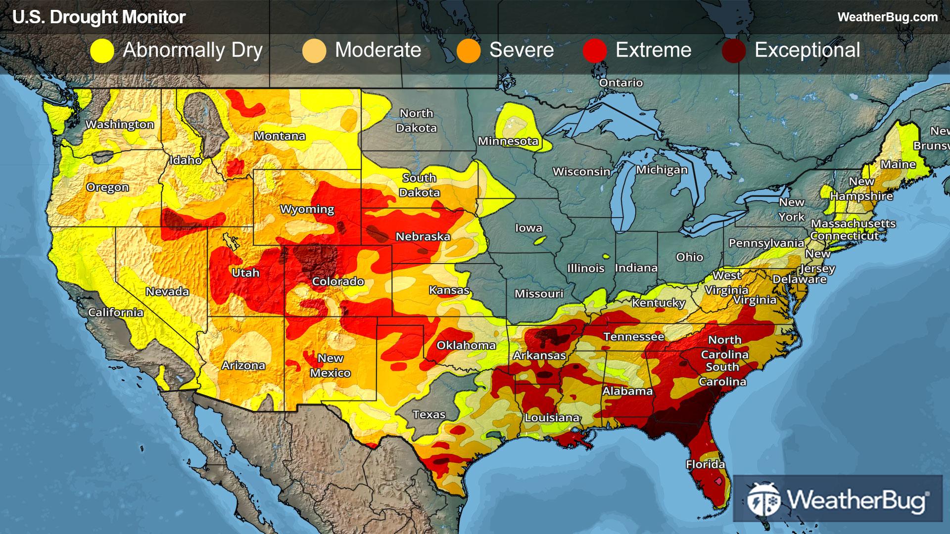
Unseasonably hot and dry weather dominated the entire Western region this week. The one exception is northern California, where late-season moisture provided a boost to short-term stream flows and soil moisture. However, it did little to change the unusually low snow cover across the northern Sierra Nevada.
Recent moisture did allow for some improvements in western and north-central Montana, as well as far southwestern New Mexico. Moderate to severe drought (D1-D2) contracted in north-central Montana and far southwestern New Mexico, while abnormal dryness decreased in coverage across western Montana.
The hot and dry weather exacerbated impacts across much of Arizona, along with scattered areas throughout the West. Extreme drought (D3) increased in coverage across northeastern New Mexico. A new area of severe drought (D2) was added to eastern Montana, while severe drought spread across Arizona into far southern Utah. Localized degradations were made to moderate drought (D1) in northeastern Montana and a small portion of California, while abnormal dryness (D0) was added to northwestern Washington.
High Plains
Light to moderate precipitation overspread much of the High Plains, with the highest amounts (0.5 to 1.5 inches) falling in central Colorado. This precipitation generally fell as snow in the mountains and higher elevations, with rain in the lower elevations. However, across the rest of the region, the moisture was not sufficient to lead to substantive improvements.
Improvements were made in central Colorado, with moderate drought contracting. Drought conditions covered 100% of Colorado last week, but this beneficial moisture allowed that number to drop to 96.23%. While still substantial, this is a trend in the right direction.
Despite cooler temperatures lowering evapotranspiration rates, some degradation occurred across Kansas, Nebraska, and far western North Dakota. Most notably, an area of exceptional drought (D4) was added to south-central Nebraska, while exceptional drought spread farther into western Nebraska. Extreme drought (D3) worsened in central Nebraska and far southwestern Kansas, with a new area of extreme drought added to central Kansas.
Midwest
Following a period of sustained wetness across the region, drier weather overspread much of the Midwest this week. Unseasonably cold temperatures reduced evapotranspiration rates, and the pause in precipitation was mostly welcome for fieldwork activities that were delayed by the frequent storm systems.
Impacts from moderate drought and abnormal dryness eased across northern Minnesota and along the southern Indiana and Illinois border.
Slight degradations were noted across southeastern Missouri and right along the Ohio River in south-central Indiana as these regions missed some of the prior precipitation. These changes were made to abnormal dryness and moderate to severe drought (D0-D2).
South
Following last week’s beneficial rainfall, additional rain overspread much of Texas. Louisiana and Mississippi this week, sparking more drought reductions. Rain across central and western Texas eased drought across the Upper River Grande Valley as well.
Most notably, exceptional drought (D4) shrunk in coverage in southern Texas, while extreme drought (D3) was removed in Texas near Big Bend National Park. Moderate to extreme drought (D1-D3) was reduced across Mississippi, Louisiana, and much of eastern, southern, and southwestern Texas. Some spots of abnormal dryness (D0) were also removed in Texas, near the Houston metro area and El Paso.
Despite the beneficial rainfall, widespread severe to exceptional drought (D2-D4) continues across the South region, and it will take a sustained series of heavy precipitation events to begin any widespread easing of impacts. The beneficial rain missed the Texas Panhandle and western Oklahoma, where poor conditions continue to affect rangeland and winter wheat. Drought conditions also expanded across Arkansas.
Southeast
An active weather pattern brought widespread heavy rainfall and thunderstorms to the Deep South, providing a much-needed moisture boost to drought-stricken areas. Total accumulations over the 7-day period topped 2 inches across much of Alabama, southern Georgia, and the western Florida Panhandle, and were higher in localized areas. The rainfall eased drought conditions across portions of northern Alabama, though widespread severe to exceptional drought (D2-D4) continues.
While beneficial, the rainfall did little more than stabilize conditions further east across much of Georgia and northern Florida, where soil moisture and stream flows remain exceptionally low. As a result, no change in drought conditions occurred in these regions. More sustained rainfall would be needed to begin easing drought conditions.
Lighter precipitation fell across the Florida Peninsula, where drought conditions slowly expanded. Drought conditions remained stable in South Carolina, but drier conditions across North Carolina and Virginia resulted in some expansion of severe to moderate drought and abnormal dryness (D0-D3).
Northeast
Light to moderate precipitation overspread the Northeast region this week. The highest accumulations fell across Maine, resulting in some modest improvements to drought and abnormal dryness. Elsewhere, accumulations tended to be higher along and west of the mountains, and lighter (less than 0.5 inch) across the drought areas of the Mid-Atlantic and southern New England. Cooler-than-average temperatures lowered evapotranspiration rates, which helped to stave off more widespread degradation.
Drought indices at multiple time scales, including streamflows, supported drought expansion across the Delmarva Peninsula. Abnormal dryness expanded across portions of the Hudson Valley and southeastern Massachusetts, while drought intensified in southeastern New Hampshire.
Looking Ahead
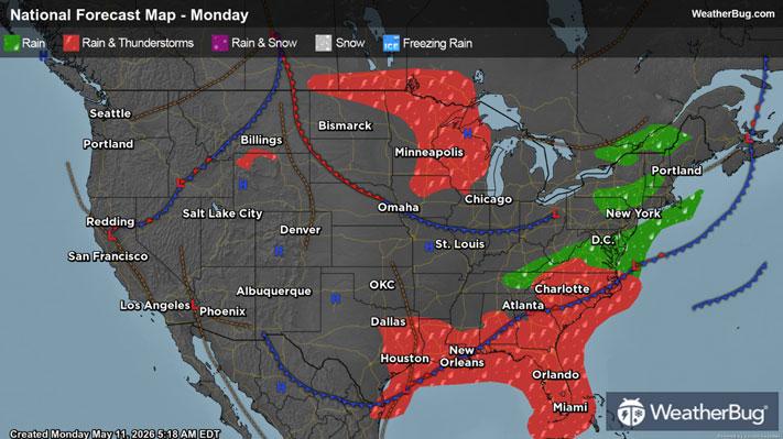
An active weather pattern is expected to persist across the Southeast over the next week, bringing 2 to 7 inches of rain from eastern Texas to southern Alabama. These rains are likely to improve drought conditions but could also increase the risk of severe weather. Georgia and Florida are expected to receive less rainfall, which may reduce the amount of drought relief in those areas.
Widespread precipitation is also forecast for the Ohio Valley and much of the East Coast, with the Northeast having the best chance for drought improvement. In contrast, the Mid-Atlantic may stay drier, limiting recovery there. The Plains are expected to see only light rainfall, offering little help for ongoing drought conditions, while the West is forecast to remain seasonably dry.
Above-average temperatures in the West are expected to speed up snowmelt, potentially boosting reservoirs in the short term but worsening long-term water supply concerns heading into summer. Meanwhile, cooler-than-average temperatures are favored across the eastern half of the continental U.S.
-------
Source: U.S. Drought Monitor