Back to forecast
Mississippi River Not So Mighty in Memphis, Tenn.
October 9, 2022 at 11:57 PM EDT
By WeatherBug Sr. Meteorologist, Chad Merrill

A popular descriptive term for the second-longest river in North America, the Mississippi, is “mighty,” because of its expansive size and volume of water. Unfortunately, the hot, dry summer has taken a severe toll on part of the Mississippi River.
Just as the calendar flipped to October, the Mississippi River in Memphis, Tenn., reached a record-low stage. The gauge on the river in Memphis measured minus-7.9 feet on Saturday morning, October 1. This is the eighth lowest on record and lowest stage in the last ten years.
So, how exactly can a river stage be negative? No, this doesn’t mean it has dried up or running underground. Simply put, years of data determine the benchmark stage that is considered a normal height of the water as measured from the muddy bottom of the river. The very high-end stage is flood stage or point when the river spills onto adjacent land and roads. On the contrary, the very low-end stage is considered “gauge zero,” but is never the bottom of the river.
A negative gauge height is a level at which it is considered dangerously low given years of historical data. River levels below zero feet, such as the status of the Mississippi River in Memphis, Tenn., then reflect a prolonged dry spell that can be used by officials to issue mandatory water restrictions, if needed.
The Mississippi flows south from its source region, Lake Itasca in Clearwater County, Minn., and collects runoff water from more than 900 miles of real estate before passing through Memphis, Tenn. It takes a large-scale dry pattern for months to cause the gauge height to slip into the negative category. Reviewing rainfall pattern trends show the Mississippi River basin has been drier than average since April. Additionally, temperatures have been above average, contributing to increased evaporation of water going into the river basin. The long-standing dry pattern has allowed moderate drought to develop along stretches of the Mississippi River.
Three out of the top five lowest Mississippi River levels in history for Memphis, Tenn., occurred in late summer to early fall. The lowest level, minus-10.7 feet, occurred on July 10, 1988. All of 1987 and the first half of 1988 was very dry along the entirety of the Mississippi Valley. This contributed to the record-low gauge height in Memphis, Tenn.
Completing the top five lowest levels of the Mississippi at Memphis, Tenn., include minus-9.86 feet on September 19, 2012, minus-9.20 feet on January 3, 2000, minus-9.10 feet on January 17, 2001 and minus-8.60 feet on August 30, 2006.
Precipitation will remain below average through October, likely allowing the Mississippi at Memphis, Tenn., gauge height to fall even more. There could be slight recovery early in the winter as preliminary indications show a return to near average precipitation.
---
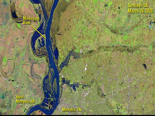
Story Image: A satellite image showing the Mississippi River near Memphis, Tenn., from March 26, 2020. (Courtesy of Earth Resources Observation and Science Center (EROS)).