Back to forecast
Winter-like Snow Continues for the Western U.S.
May 5, 2024 at 06:01 AM EDT
Updated By WeatherBug Meteorologist, Molly Robinson

Spring may have sprung, but winter weather continues to cause a nuisance for the West to close out the weekend into the work week.
A peppy storm system over the Pacific Northwest will continue to track east today and Monday. Combined with a chilly air mass, rain and snow are expected across the West heading into the work week.
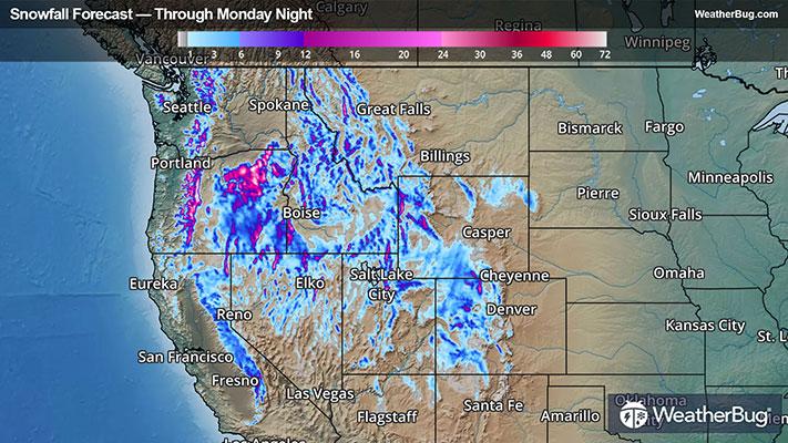
Snow is expected to dump over the Cascades along with the Great Basin, Blue Mountains, Columbia Plateau and Harney Basin with lingering snow over the Sierra Nevada. Snow is then expected to spread into the northern and central Rockies by late tonight.
Accumulations of a couple feet of snow will be common over the highest elevations in the Cascades and east into the Blue Mountains and Columbia Plateau with 7 to 15 inches over the highest elevations in the Harney Basin and far northern Nevada. Meanwhile, the Sierra Nevada and the rest of the Great Basin could see an additional 3 to 6 inches through tonight. Winter Storm Advisories and Warnings remain for these areas as well.
Heading east, 12 to 18 inches of snow will be common across the central Rockies with a few isolated points seeing close to 2 feet through Monday night. Lower elevations in the central Rockies will likely see 3 to 8 inches of snow. Similar totals will also be found across the northern Rockies in Idaho, western Montana and western Wyoming. Winter Storm Advisories, Watches and Warnings are also in place here.
Snow won’t be the only issue as this system will bring gusty winds to portions of the west as well. Lingering High Wind Warnings and Advisories remain for southern Nevada and California and extends into Utah and northern Arizona. High Wind Advisories, Watches and Warnings are also in place for western Colorado, southern Wyoming and northeastern Montana for today as well. Wind gusts of 50 to 55 mph will be common within these areas with some areas seeing gusts as high as 60 to 65 mph!
It’s a good idea to have an emergency kit packed with supplies in the event power or communication is lost. Simply having a battery-powered radio, fresh batteries, non-perishable food, fresh blankets and water will go a long way in remaining safe during treacherous weather conditions. To go the extra mile, pack any prescription medication, first-aid kits and/or flashlights too to be prepared for prolonged periods of being in a blackout.
Be sure to have multiple ways to get the latest weather information from local TV, weather radio, or the WeatherBug app.