Back to forecast
Potent Front Brings Storms, Gusty Winds To Eastern U.S.
February 29, 2024 at 12:45 AM EST
By WeatherBug Meteorologist, Mark Ellinwood

February will end with a sharp change in temperature thanks to a potent cold front. Dangerous thunderstorm, gusty winds and even a few snow showers will also be in the forecast.
Rain and embedded thunderstorms along and ahead of a quickly-advancing cold front will push through the eastern third of the country today into tonight.
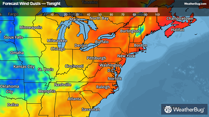
Daily rainfall of a half inch to an inch will be common across the Northeast and Mid-Atlantic, with rain totals tapering off the further south you go across the Carolinas and into the Southeast. It will remain breezy behind the cold front across the Mid-Atlantic and Northeast tonight through Thursday afternoon, with most areas seeing similar peak sustained winds of 15 to 25 mph and gusts up to 30 to 45 mph. A few spots including Cape Cod will see slightly higher winds today and Thursday.
Wind Advisories are posted up and down much of the East Coast and into parts of the Great Lakes, and Blue Ridge Mountains tonight into Thursday. Parts of Upstate New York, western and central Massachusetts, Cape Cod and the Islands, and Downeast Maine also have High Wind Warnings where the strongest winds are expected to occur.
Some snow showers will also occur in the northeastern U.S. behind the cold front tonight through Thursday. Most areas that see snow will only get a coating to an inch of accumulation, but locally higher amounts of 1 to 3 inches are possible through Thursday evening mainly in the higher elevations of northern New England and downwind of the Great Lakes.
Make sure to frequently check WeatherBug for updates, as a watch can quickly turn into a warning upon imminent danger. Make sure to understand the difference between a watch and a warning should they be issued. A watch means that conditions are favorable for severe weather to occur and to be on alert for any rapidly changing conditions. A warning means that severe weather is imminent, and you should act fast to remain safe.