Snow and Ice Lingering Across New England
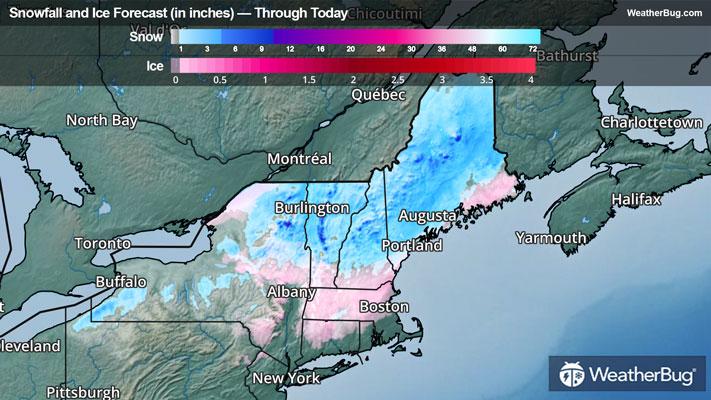
Snow and ice will linger across New England today as a low pressure system departs the region.
The steadiest precipitation will occur this morning before drier air starts to win out this afternoon. Even still, snow and even freezing rain will linger through at least the middle or later afternoon hours over portions of Maine before drier weather settles across the entire region.
When the snow finally stops falling, accumulations of 2 to 6 inches will be common from Upstate New York through northern Maine, with the highest accumulations found over the higher elevations of Vermont and New Hampshire.
Farther south, 0.05 to 0.15-inch ice accretions will be possible across portions of the Hudson Valley into Massachusetts, southern Vermont, and southern New Hampshire.
Winter Weather Advisories remain in place across far northeastern Pennsylvania into eastern New York, Connecticut, northern Rhode Island, much of Massachusetts, southern Vermont, southern New Hampshire, and southern and eastern Maine.
Following this storm system, a much milder weather pattern is expected to take shape across the Northeast through the end of the week.
Be sure to download the WeatherBug app to stay up to date on the latest on this changing weather. It’s never too early to have a supply kit packed in case of inclement weather. A simple kit including a weather radio, water, blankets, batteries, and non-perishable food items will go a long way in the event of a power outage.