Major Snow and Ice Storm Shifts to the Northeast and New England
Mother Nature will continue to deliver snowy and icy weather across the Northeast and New England.
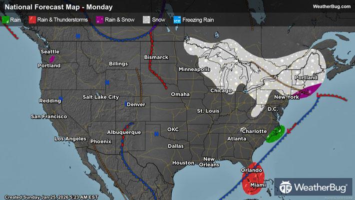
Bitter cold Arctic air has merged with a “cut-off” low from the West coast to produce a major winter storm, currently lingering from Appalachia and the Great Lakes eastward after affecting much of the Central U.S. Around 3 to 10 inches of snow has fallen from the Texas panhandle to the Ohio Valley, including some freezing rain and sleet from eastern New Mexico to southeastern Virginia. Ice accretion amounts of 0.10 inches up to 0.50 inches have been reported, causing nearly 900,000 power outages. Both the cold front and the low pressure system will continue to advance into the Eastern U.S. throughout the day today.
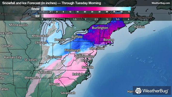
When all precipitation concludes, this will translate into a large swath of 5 to 15 inches or more from the Lower Midwest to the Mid-Atlantic and Northeast. Higher totals in the Upper Ohio Valley, Northeast, and New England of 12 to 18 inches are likely where snow rates could reach 1 to 3 inches per hour. The Boston area could approach 2 feet of snow into Monday. Immediately south of this snow, there will be a wintry mess of snow, sleet, and freezing rain. The wintry mess has ended in much of the Central U.S. and western Mid-Atlantic, but will continue to be found in parts of the southern to central Appalachians, coastal Mid-Atlantic, and the Carolinas. South of this wintry mix, expect a cold rain for the rest of the Southeast.
Significant snow/sleet and ice accumulation has occurred for much of the Central and Eastern U.S. The storm continues in the Northeast and eastern Great Lakes with Winter Storm Warnings and Winter Weather Advisories still in place across the Ohio Valley, Northeast, Mid-Atlantic, and Carolinas. Ice Storm Warnings are also in effect from the western and central Carolinas and portions of northern Georgia. The heaviest freezing rain amounts could exceed a half inch to one inch by the end of today in parts of the South as the low tracks eastward. Breezy conditions coupled with heavy ice amounts will likely cause tree damage and prolonged power outages in scattered areas across the South and isolated spots in the Mid-Atlantic.
Light to moderate snow will linger over New England into Monday before finally exiting early Tuesday morning.
It's worth noting that it will be extremely cold over much of the central and eastern U.S. this weekend, with wind chills getting anywhere from 10 to 40 degrees below zero. Cold Weather Advisories and Extreme Cold Warnings have been plastered across a large portion of the U.S. for this reason.
Additionally, these cold weather conditions have caused a few ice jams in the Great Lakes area. The presence of these ice jams has caused several Flood Advisories to be issued in Michigan and Illinois. Further to the south, scattered Flood Advisories/Warnings have been put in place for heavy rainfall in eastern Tennessee, northern and southern Alabama, eastern Mississippi, and southern Louisiana.
Be sure to download the WeatherBug app to stay up to date on the latest on this changing weather. It’s never too early to have a supply kit packed in case of inclement weather. A simple kit including a weather radio, water, blankets, batteries, and non-perishable food items will go a long way in the event of a power outage. It’s always best to avoid traveling in rough weather as the roads will be dangerous.