
Rounds of Snowy, Icy Weather Set to Impact Eastern Two-Thirds of U.S.
We are in the thick of winter and Mother Nature plans on delivering plenty of snowy, icy weather. One round of snow impacts the north-central and northeastern U.S. over the next several days, while a significant snow and ice storm threatens the south-central U.S. into the Eastern Seaboard.
A low pressure system will form over the Great Lakes today, which will drift into southeastern Canada on Thursday and Friday. This low pressure system will bring rounds of snow to the northern Plains, Upper Mississippi Valley, Great Lakes and the interior Northeast today. Snow will then continue across the Great Lakes and interior Northeast on Thursday and Friday.
Most spots will end up with light accumulations. However, cold northwesterly winds moving over the warm Great Lakes will cause some lake enhancement. Areas east or east-southeast of Lake Michigan, Lake Erie and Lake Ontario could see moderate to even some heavy snow as a result.
By the end of Friday, snowfall accumulations will generally range from one-half inch up to 3 inches. The favored Great Lake snow belts will likely record 3 to 8 inches, with even some spots approaching or exceeding a foot of fresh powder!
Winter Storm Warnings and Winter Weather Advisories have been posted across parts of the north-central and northeastern U.S. This includes much of North Dakota, northeastern South Dakota, western and southern Minnesota, northern Iowa, far northern Illinois, southern Wisconsin and much of Michigan’s Lower Peninsula as well as northwestern Pennsylvania and western New York.
Plan on slick, slippery road conditions, especially early and late in the day. This snow will likely impact morning and evening commutes, so slow down and use caution if you have to travel.
As if that wasn’t enough, a major winter storm is slowly coming together and will impact the eastern two-thirds of the U.S. by the end of the work week through the upcoming weekend.
An Arctic cold front will drop south across the Rockies and High Plains on Friday, while a low pressure system that has been “cut-off” from the normal weather flow pushes into the Desert Southwest. Bitter cold Arctic air will combine with moisture from the “cut-off” low to produce wintry weather across the Central U.S. Both the cold front and the low pressure system will slowly advance into the Eastern U.S. on Saturday and Sunday.
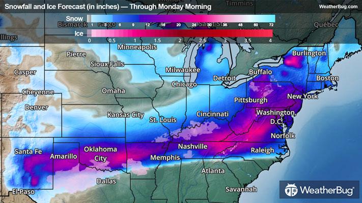
This will translate into a swath of snow from the Rockies and High Plains into the Lower Midwest, Mid-Atlantic and Northeast. Immediately south of this snow, there will be a wintry mess of snow, sleet and freezing rain. The wintry mess will likely be found across northern Texas, southern Arkansas and northern Louisiana into the Tennessee Valley, southern Appalachians and the Carolinas. South of this wintry mix, expect a cold rain for the rest of the southern Plains, Gulf Coast and southern parts of the Southeast.
Depending on the exact track, there will be both significant snow/sleet and ice accumulation. To prepare for this winter storm, Winter Storm Watches have been issued across the south-central U.S. This includes areas from eastern New Mexico, southern Kansas, much of Oklahoma and northern/central Texas into western Kentucky, western/central Tennessee, northern Mississippi and northern Alabama.
Be sure to download the WeatherBug app to stay up to date on the latest on this changing weather. It’s never too early to have a supply kit packed in case of inclement weather. A simple kit including a weather radio, water, blankets, batteries, and non-perishable food items will go a long way in the event of a power outage. It’s always best to avoid traveling in rough weather as the roads will be dangerous.