Intense Severe Storms Malign Plains, East Coast
While a major springtime storm will dump significant snow over the Great Lakes, its most widespread impact will be felt with severe weather generating along its cold front through Monday.
Forming from the remnants of an atmospheric river in the Northwest, a new major storm system burgeons in the northern Plains and Great Lakes today. Even stronger temperature gradients than last week’s storm are expected behind its cold front as it rushes over the southern Plains and Lower Midwest. This quick-moving front, paired with ample strong upper-level wind support and the strong northward transport of humid Gulf air into the Low Plains and Mississippi Basin, will enable severe squall lines and isolated leading supercells launching this afternoon and persisting overnight.
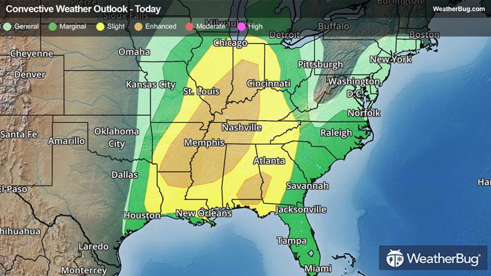
Today, the Storm Prediction Center has issued two separate Enhanced Risks (a 3 out of 5 on the severity scale). The first region, from northern Louisiana and Texas through southwestern Indiana, will hold a more intense and concentrated risk of damaging straight-line winds and tornadoes embedded within any severe squall lines, alongside isolated large hail. Cities under this risk include Indianapolis, Nashville and Memphis, Tenn., Louisville, Ky., Poplar Bluff, Mo., Jackson, Miss., and Shreveport, La.
The second Enhanced Risk region, situated over southeastern Alabama, southwestern Georgia, and part of the Florida Panhandle, will become particularly unstable despite the front arriving late tonight. Here, a few long-lived supercells could spawn, heightening the coverage and intensity of both large hail and tornadic activity. Cities under this risk tonight include Columbus, Ga., and Montgomery and Dothan, Ala.
An enveloping Slight Risk (a 2 out of 5 on the severity scale) currently covers areas from Illinois and southern Michigan through the central Gulf Coast from southern Louisiana through the Florida Panhandle. Cities at risk here include St. Louis, Chicago, Toledo and Cincinnati, Ohio, New Orleans, Atlanta, Pensacola, Fla., Mobile, Ala.
As the low pressure system churns eastward through Monday, a new warm front lift over the Southeast and Mid-Atlantic on Monday morning, creating a corridor of moderate to heavy rainfall that slides across the Northeast. Meanwhile, the Deep South and East Coast be threatened by the same cold front as it launches eastward, perpetuating severe thunderstorm lines. In the South and Lower Mid-Atlantic, isolated to widely scattered strong to severe thunderstorms could ignite well ahead of the cold front as well, mainly on Monday afternoon and evening. Additionally, upper-level energy and favorable terrain will enable storms to become stronger along the East Coast and Piedmont than those that launch today.
A rare Moderate Risk (a 4 out of 5 on the severity scale) has been posted for central Maryland through north-central South Carolina. Here, a few supercells producing long-lasting tornadoes are possible ahead of the cold front, which itself will slam down widespread damaging gusts across the region. Cities under risk include Washington, D.C., Richmond, Va., and Raleigh and Durham, N.C.
Furthermore, an Enhanced Risk and Slight Risk envelop areas from south-central New York through northern Florida. Cities under these regions include Baltimore, Virginia Beach, Va., Charlotte, N.C., Charleston and Columbia, S.C., Savannah, Ga., and Tallahassee and Jacksonville, Fla. Here, widely scattered to scattered damaging gusts and isolated tornadoes could still produce plentiful issues. In the Southeast specifically, large hail will be more prevalent.
Heavy, prolonged rain is also likely in the Northeast on Monday as the warm and cold fronts sweep overhead in quick procession. Totals of 1 to 2 inches are likely for the northern Mid-Atlantic and New England, with locally 2 to 3 inches or more possible across the Catskills and northern Appalachia. This may lead to urban flooding, especially where poor drainage exists. If you approach a road covered in water, remember the old saying, “Turn Around, Don’t Drown!”
Make sure to know the difference between a watch and a warning should they be issued. A "watch" means that conditions are favorable for severe weather to occur, and to be on alert for any rapidly changing conditions. A "warning" means that severe weather is imminent, and you should act fast to remain safe.
The best way to remain safe is to stay prepared and informed about your local weather. Have a severe weather kit packed with a battery-operated radio, water, and non-perishable food items. Also, check the WeatherBug app frequently for any updates on today's severe weather. Remember, "When Thunder Roars, Go Indoors!"