Severe Storms Rattle Texas to New York
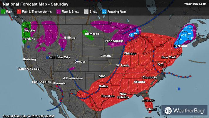
A strong low pressure system storming across the north-central U.S. today will continue this week’s train of severe weather from the eastern Great Lakes through southern Texas, affecting tens of millions of people.
Poised to revolve eastward across the Great Lakes, the storm’s low pressure center will funnel in anomalously warm temperatures, and, as a result, strong instability. This energy will be ignited ahead of a strong cold front draped from the eastern Great Lakes.
Primarily, the cold front will form squall lines and thunderstorm clusters with embedded severe storms from the eastern Great Lakes, across the Ohio Valley, and into the Mid-South. In the Deep Mid-South, severe storm impacts are more so expected this morning, with activity weakening into the afternoon. Isolated damaging wind gusts, hail, and a few tornadoes, mainly in the Upper Ohio Basin, are all in play.
Near the very tail end of the front in Texas, short-lived supercells are possible, rippling eastward through the day. Under these cells, the greatest hail impacts are likely alongside damaging winds, and although tornado chances are negligible in this region, one or two cannot be ruled out. A few hailstones may reach or even surpass tennis-ball size amongst the strongest storm cells!
Additionally, these storms could also produce locally heavy rainfall, with the heaviest rain concentrated in the Mid-South. Rain totals of 1 to 2 inches are expected through the weekend, with locally higher amounts up to 3 inches possible.
Currently, there is a Tornado Watch was issued from Ark-La-Tex area to central Arkansas which includes Texarkana, Texas and Little Rock, Ark.
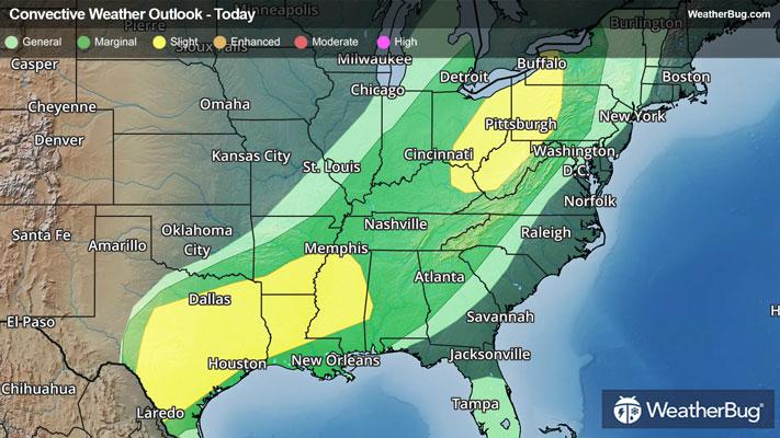
According to the Storm Prediction Center, there are two separate regions holding a Slight Risk (a 2 out of 5 on the severity scale) for severe weather. The first area is posted from eastern Kentucky through western New York, which holds a heightened risk for tornadoes, while the second is posted from far west-central Alabama through eastern Texas, which holds a heightened risk for large hail. Both will also likely see scattered reports of damaging winds. There is also a larger Marginal Risk (a 1 out of 5 on the severity scale) encompassing these two greater risks from Lake Ontario and eastern Michigan through the Texas-Mexico border and much of the Deep South.
Cities affected under the Slight Risks include Houston, Dallas, and San Antonio, Texas, Shreveport, La., Jackson, Miss., Charleston, W. Va., Cleveland and Columbus, Ohio, Buffalo, N.Y., and Pittsburgh.
Previously under this system, two tornadic severe thunderstorms spawned on Friday. One of these produced a long-tracked, destructive, and ultimately deadly tornado in southwestern Michigan, impacting the communities of Three Rivers and Union City. Large hail reports were also clustered tightly under severe storms in eastern Nebraska and western Iowa, with hailstone diameters of up to 1.5 inches observed.
Make sure to know the difference between a watch and a warning should they be issued. A “watch” means that conditions are favorable for severe weather to occur, and to be on alert for any rapidly changing conditions. A “warning” means that severe weather is imminent, and you should act fast to remain safe.
The best way to remain safe is to stay prepared and informed about your local weather. Have a severe weather kit packed with a battery-operated radio, water, and non-perishable food items. Also, check the WeatherBug app frequently for any updates on today's severe weather. Remember, "When Thunder Roars, Go Indoors!”