Severe Storms Pepper Southern Plains to Lower Great Lakes

A broad storm will deliver plenty of severe weather headaches to the central and eastern part of the nation through the beginning of the weekend. Everything from a couple of strong tornadoes to flooding downpours will be on the weather menu.
As the storm organizes across the Plains this evening, several clusters of thunderstorms have developed from Oklahoma to southwestern and central Michigan. This activity will multiply and rumble eastward into the Mississippi and Ohio valleys through early Saturday morning. Damaging hail up to baseball size, scattered destructive gusts up to 70 mph, and tornadoes could accompany the most intense thunderstorms. A few tornadoes could be strong.
Tornado Watches are in effect across southwestern Missouri and southeastern Kansas, central and northeastern Kansas to western and central Iowa, northern Missouri to eastern Iowa, and central and eastern Oklahoma. Cities such as Oklahoma City and Tulsa, Okla., Des Moines, Iowa, Lincoln, Neb., Concordia, Salina, and Russell, Kan., are included.
A Severe Thunderstorm Watch remains in effect in northern Indiana and southwestern Lower Michigan. South Bend, Ind., is included.
The government’s Storm Prediction Center has an Enhanced Risk in place from parts of southwestern Iowa to far northern Texas through Saturday morning. This includes Tulsa, Okla., Lincoln, Neb., and Kansas City and Springfield, Mo.
A larger Slight Risk surrounds the Enhanced Risk from southern Wisconsin to much of northern and central Texas, including St. Louis, Wichita, Kan., Oklahoma City, Okla., and the Dallas-Fort Worth metroplex.
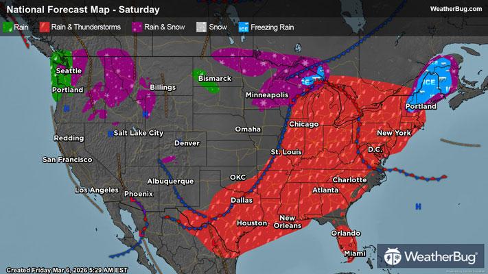
The system's cold front will be the main agitator for severe thunderstorms on Saturday as it pushes east. Many lines of thunderstorms will be possible from western New York and the Ohio Valley into the Lower Mississippi Valley and eastern Texas. Gusty winds and hail will be the main threats, but a few tornadoes could also develop.
Storms could also produce locally heavy rainfall, with the heaviest rain concentrated on the southeastern Plains and Lower Mississippi Valley. These regions will see 1 to 3 inches of rain through the end of the week, with locally higher amounts up to 4 inches possible.
Make sure to know the difference between a watch and a warning should they be issued. A “watch” means that conditions are favorable for severe weather to occur, and to be on alert for any rapidly changing conditions. A “warning” means that severe weather is imminent, and you should act fast to remain safe.
The best way to remain safe is to stay prepared and informed about your local weather. Have a severe weather kit packed with a battery-operated radio, water, and non-perishable food items. Also, check the WeatherBug app frequently for any updates on today's severe weather. Remember, "When Thunder Roars, Go Indoors!”