Severe Storms Take Aim at the Northeast, Midwest, Plains
Summer-like warmth and humidity spreading northward will help fuel rounds of severe thunderstorms across the Central U.S. into the Northeast today.
A boundary will extend from the southern Plains into the Midwest and Great Lakes. This boundary will separate summer-like heat and humidity to the east with cooler, drier to the west. As these two air masses clash, thunderstorms will fire along this boundary in the afternoon and evening.
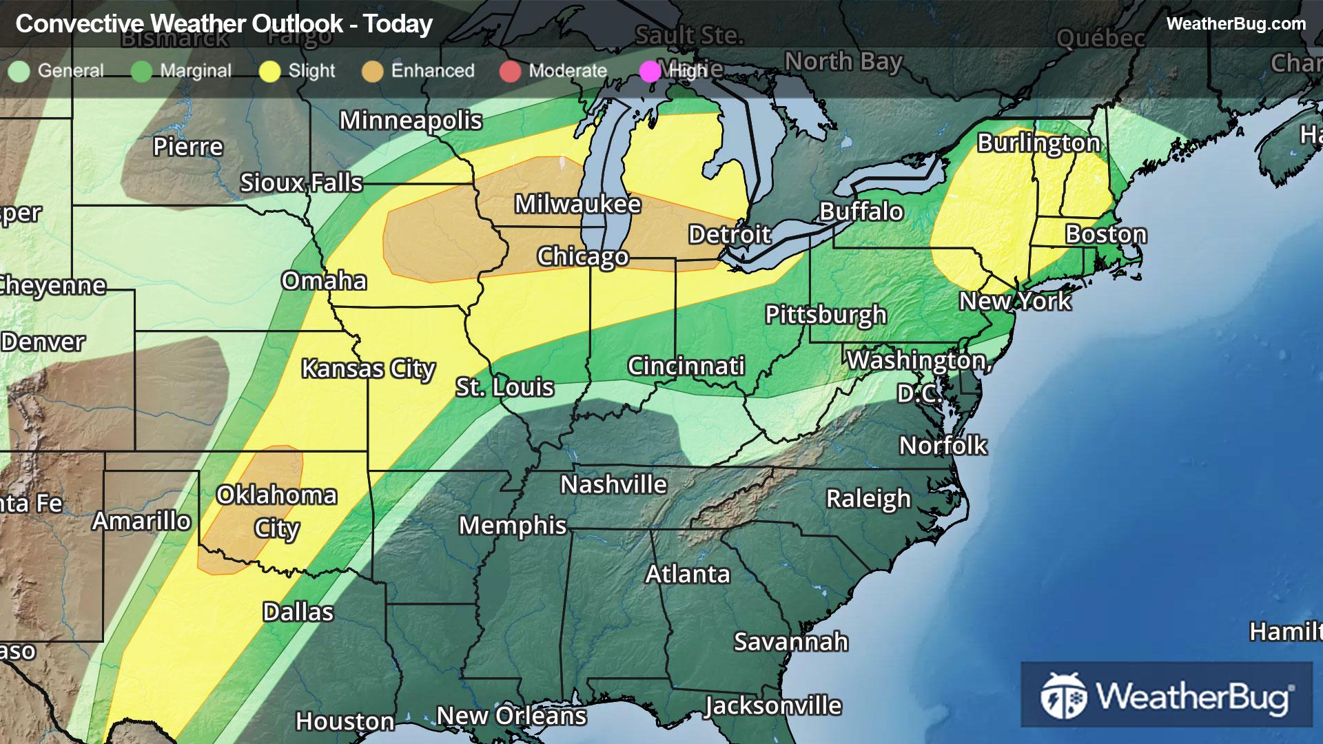
The government's Storm Prediction Center has placed two areas in an Enhanced Risk, or a 3 out of 5 on the severe weather probability scale. The first area covers eastern Iowa, southern Wisconsin, and northern Illinois into southern Michigan, far northern Indiana, and northwestern Ohio. The other area stretches from far north-central Texas into western Oklahoma. A larger Slight Risk, or a 2 out of 5 on the severe probability scale, is in effect from the southern Plains into the Midwest and Great Lakes.
All modes of severe weather are likely today, including damaging winds exceeding 60 mph, flooding rainfall, large hail, and a few tornadoes. Some cities at risk include Midland, Abilene and Wichita Falls, Texas, Oklahoma City, Wichita, Kan., Kansas City, Mo., Des Moines, Iowa, Chicago, Milwaukee, Detroit, and Cleveland.
A second area of concern is found across northeastern Pennsylvania, eastern New York, northwestern Connecticut, western Massachusetts, much of Vermont, and southern New Hampshire. Here, a fast-moving upper-air disturbance will traverse along a nearly stationary front.
The Storm Prediction Center has placed this area in a Slight Risk, which includes Scranton, Pa., Albany, N.Y., and Burlington, Vt. Heavy downpours and damaging wind gusts will be the primary threats from thunderstorms today.
In addition to the severe weather threat, heavy rainfall may lead to localized flooding across portions of Wisconsin and Michigan where Flood Watches have been issued for today. Localized rain amounts of 1 to 2 inches will be possible and may lead to flooding of low-lying areas as well as in creeks and streams.
Additional strong to severe thunderstorms will be expected again on Wednesday. Wednesday's threats will stretch from the southern Plains to the Midwest, Great Lakes, Ohio Valley, and possibly parts of the Northeast.
Make sure to know the difference between a watch and a warning should they be issued. A "watch" means that conditions are favorable for severe weather to occur, and to be on alert for any rapidly changing conditions. A "warning" means that severe weather is imminent, and you should act fast to remain safe.
The best way to remain safe is to stay prepared and informed about your local weather. Have a severe weather kit packed with a battery-operated radio, water, and non-perishable food items. Also, check the WeatherBug app frequently for any updates on today's severe weather. Remember, "When Thunder Roars, Go Indoors!"