Back to forecast
Severe Weather Zips Across Ohio Valley, Pennsylvania
April 15, 2024 at 12:09 AM EDT
UPDATED By WeatherBug Meteorologists

Severe weather will continue to rumble over parts of the Ohio Valley and Northeast this evening.
Moisture will not be the most abundant in this setup, but strong upper-level winds, instability and a frontal system has launched dangerous thunderstorm activity this evening. A squall line will continue to track southward toward the Mason-Dixon line. It is here storms should start to weaken as the midnight hour approaches.
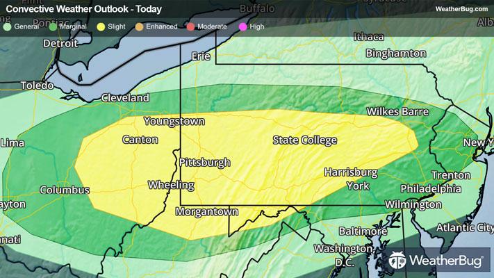
The government’s Storm Prediction Center currently has a Slight Risk for severe weather from eastern Ohio into northern western Virginia and central Pennsylvania. Surrounding it is a Marginal Risk that extends into southeastern New York, western Maryland, and northern West Virginia. Cities that will need to keep an eye on the skies are Canton, Ohio, Pittsburgh, Harrisburg, and Philadelphia, Pa., Morgantown, W. Va, and Newton, N.J.
The main threat will be damaging winds exceeding 50 mph. However, severe hail greater than an inch in diameter and a couple of tornadoes will be on the ballot as well with any stronger activity.
On Monday, severe weather will shift focus to the Great Plains. Thunderstorm development will likely occur in the afternoon to early evening hours across the southern to central Plains states. A bimodal setup looks to be the case here, with a round of storms firing from Kansas to Nebraska in the late afternoon. After sunset, another set of storms will develop along a frontal passage in west Texas and western Oklahoma.
As such, an Enhanced Risk for severe weather has been issued for portions of the north-central Texas and west-central Oklahoma as well as northern Kansas and southwestern Nebraska. This includes the cities of Lincoln Neb., Lawton, Enid, Okla., and Salina and Manhattan, Kansas. Additionally, a more widespread Slight Risk has been issued covering portions of the Texas panhandle as well as central Texas, most of Oklahoma, Kansas, Nebraska, and southern South Dakota. This risk also includes extreme western Missouri and western Iowa. Cities included in this risk are Fort Worth Tex., Oklahoma City, Tulsa, Okla., Kansas City, MO, and Omaha, Neb.
Large hail, damaging wind gusts, and a few tornadoes are the primary threats associated with these storms. Very large hail will be possible from west Texas to southern Nebraska.
Be sure to keep up with the latest watches and warnings on the WeatherBug website and our WeatherBug app. Also, it would be smart to have a severe weather plan in place in case severe weather strikes your area.