Potent Thunderstorms Pepper Deep South and Southeast U.S.
Dangerous thunderstorms will pepper parts of the Deep South and Southeast throughout this evening and tonight. Hail, damaging wind gusts, and a few tornadoes will be possible.
Clusters and individual robust thunderstorms will merge and move east through tonight, covering much of northeastern Louisiana and Mississippi to northern Alabama/Georgia. A warm, humid air mass will team up with a disturbance aloft to maintain the thunderstorms intensity well after sunset.
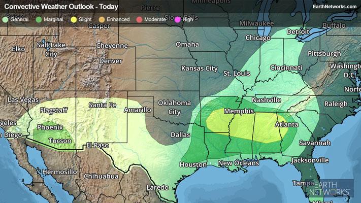
Severe Thunderstorm Watches are in effect from northeastern Louisiana to northern and central Mississippi, far southwestern Tennessee, and northern and central Alabama to far northwestern and west-central Georgia. Birmingham, Tuscaloosa, and Huntsville, Ala., and Tupelo, Greenville, and Jackson, Miss., are included.
The greatest severe weather risk zone will be found from the Interstate 20 and 22 corridors to Interstate 66 from Mississippi to western and central Georgia. Southern Tennessee and as far south as near the Interstate 10 corridor could be peppered by dangerous weather as well.
Cities such as Birmingham, Dothan, and Tuscaloosa, Ala., Chattanooga, Tenn., Columbus and Atlanta, Ga., and Alexandria, La., are included. Isolated hail up to golf ball size and scattered damaging wind gusts up to 70 mph in addition to a couple tornadoes will be the main risks.
Soaking rain, often in a short time, will be part of the most intense thunderstorms make up. One to 2 inches will be common, with locally 2 to 3 inches or more possible. This may lead to urban flooding, especially where poor drainage exists. If you approach a road covered in water, remember the old saying, “Turn Around, Don’t Drown!”
Make sure to know the difference between a watch and a warning should they be issued. A "watch" means that conditions are favorable for severe weather to occur, and to be on alert for any rapidly changing conditions. A "warning" means that severe weather is imminent, and you should act fast to remain safe.
The best way to remain safe is to stay prepared and informed about your local weather. Have a severe weather kit packed with a battery-operated radio, water, and non-perishable food items. Also, check the WeatherBug app frequently for any updates on today's severe weather. Remember, "When Thunder Roars, Go Indoors!"