
Wednesday's Weather Outlook
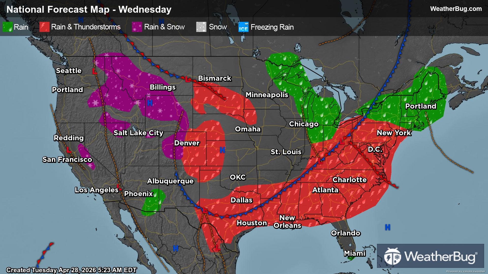
Mother Nature has no major plans on changing up the weather for Wednesday. The eastern two-thirds of the nation remain locked into a wet, stormy pattern, while drier conditions prevail across the West.
A cold front will creep south and east across the eastern two-thirds of the U.S. on Wednesday. The eastern fringes of this front will advance across the Eastern Seaboard throughout the day, while the southern portions will be draped over the south-central U.S.
Ahead of the front, warm and humid air from the Gulf will be transported northward into the U.S. Rain showers and thunderstorms will be found for most areas along and east of the Mississippi River as well as the southern Plains. While possible throughout the day, the best chance for rain and thunderstorms will be morning for the Ohio and Tennessee valleys, then the afternoon and evening for the East Coast, Gulf Coast and southern Plains.
While not as widespread or intense as the past few days, there will be the potential for strong to severe thunderstorms, mainly in the Mid-Atlantic, southern Plains and western half of the Gulf Coast. The main concern within thunderstorms would be damaging winds and torrential downpours. However, some hail and perhaps a brief tornado cannot be ruled out.
At the same time, the western fringes of this elongated cold front will be draped over the Rocky Mountains for the middle of the work week. This will result in rounds of moisture and energy moving along the front, triggering chances of precipitation. Temperatures will generally be too mild, so any snow chances will remain limited to the tallest peak. The rest of the Rockies into the High Plains region will likely just see rain showers.
High pressure will be in control of the weather west of the Rockies. This will foster dry and quiet weather as a result.
Unseasonably cool weather will be in the forecast for much of the nation, especially throughout the Plains and Midwest. Temperatures will be closer to average or even slightly above normal along the immediate West Coast and the Southeast.
Highs will reach the 40s and 50s across much of the Mountain West and northern Plains into the Great Lakes and interior Northeast. However, the mercury could only climb into the 20s and 30s for the highest points of the Cascades, Sierra Nevada and Rocky Mountains. Expect 60s and 70s for the rest of the Northwest and Great Basin into the central Plains, the Ohio and Tennessee valleys, southern New England and Mid-Atlantic. Warmer 80s and 90s are in store for most of California and the Desert Southwest into the southern Plains, Gulf Coast and Southeast.