
Monday's Weather Outlook
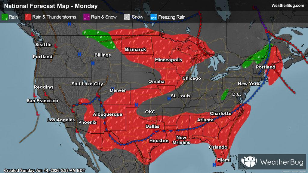
The workweek begins with active weather scattered around the U.S. thanks to multiple storm systems.
This Monday, portions of the High and Central Plains, Desert Southwest, South-Central and Southeast U.S., along with Eastern New England can expect cloudy skies along with scattered showers and thunderstorms throughout the day. This will become more widespread in the afternoon and evening hours.
Additionally, spots such as north-central Montana, eastern West Virginia, far southwestern Pennsylvania, and far western Maryland, along with northwestern New England may experience isolated showers on Monday.
Meanwhile, limited moisture west of the Rockies will keep much of the region calm, where the Pacific Northwest down through the Great Basin can anticipate for the most part to stay high and dry, with clear and partly cloudy skies. Much of the Northeast, Lower Midwest and the northern portion of the Southeast U.S. can also expect clear and partly cloudy skies and to stay dry.
Across the Northeast, high temperatures will be in the 60s and 70s thanks to the cold front that passed through on Sunday. The Southeast can expect temperatures in the 80s and 90s, with temperatures on the cooler side further inland. In the West, high temperatures will vary greatly, ranging from the 80s to over 100 degrees, where much of the latter will be seen in the Desert Southwest. In the Mountain West, regions of higher elevations can expect temperatures in the 50s and 60s. Meanwhile, the rest of the U.S. can expect highs in the 70s and 80s. However, there could be more fluctuations in localized areas