
Weekend Weather Preview
The eastern half of the nation will face wet, wintry precipitation through the weekend as low pressure plagues weekend plans.
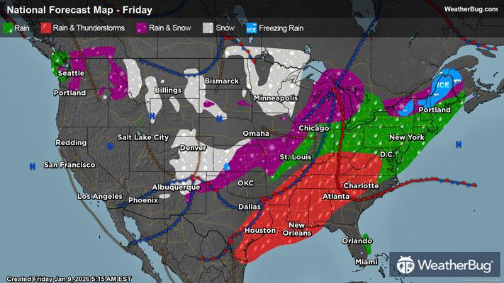
Saturday
A passing low pressure system continues to bring mixed precipitation to the eastern half of the Nation.
In the Northeast, a significant mix of precipitation will plague the area as snow, ice, rain, and thunderstorms are all possible. A rain/snow mix will be possible for all states hugging the U.S.-Canada border and Great Lakes. Within this mix, icy conditions are possible for Maine, New Hampshire, Vermont, Massachusetts, New York, and northern Pennsylvania. Rain will hug the New England coastline, and rain showers with isolated thunderstorms will encompass most of the Mid-Atlantic region.
In the Southeast, rain and isolated thunderstorms will follow a pattern like the Mid-Atlantic, but high pressure off the eastern coast of Florida will allow for clear weather over most of Florida.
The Deep South and Gulf Coast states will also see some rain and thunderstorms, with Texas escaping most of the unstable weather this Saturday. Texas will see some rain showers along the state’s coast but will remain clear throughout most of the state.
The Midwest will feel the effects of this low pressure system passing as well, with snow showers encompassing the states surrounding the Great Lakes. Warmer air will plague some areas with a rain and snow mix. Michigan will take the worst of the weather with icy conditions across the southern portion of the state, bleeding into northern Indiana and Ohio. There will also be some spotty areas among the Northern Plains that receive snowfall, but the remainder of the Midwest will see dry weather conditions.
The Mountain West will see a break from wintry weather with high pressure overhead and clear weather. This will offer a great opportunity for driving on cleared roads and enjoying the much-anticipated snow accumulation on the ski slopes.
The West Coast will be primarily dry, with precipitation only lingering around the Olympic Peninsula. This precipitation will reach the Northern Cascades and fall as a rain and snow mix with icy conditions possible.
Below-freezing temperatures in the teens will grip the Midwest in Minnesota, North Dakota, and South Dakota, while higher peaks along the Rockies will also see below-freezing temperatures.
A substantial portion of the country will be in the 30s and low 40s this Saturday, with New England, the Great Lakes, Northern Plains (apart from below-freezing areas), and the lowland areas within the Mountain West.
50-degree temperatures will encompass New Jersey, Pennsylvania, and the Ohio Valley. This temperature trend will continue through the Tennessee Valley, Central Plains, and even reaching down as far south as Texas. The Pacific Northwest coast down through California's Central Valley will also see temperatures in this range.
A sizable portion of the Mid-Atlantic down through the Southeast will see temperatures in the 60s and 70s. In Florida, temperatures are expected to reach the low 80s. The Desert Southwest will see temperatures in the mid-to-high 60s.
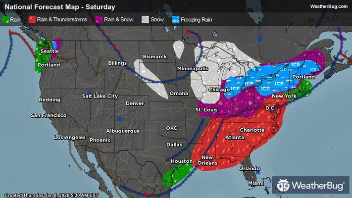
Sunday
As a low pressure system makes its way across the eastern half of the Nation, East Coast states will continue to be plagued with wintry weather over the remainder of the weekend.
In the Northeast, low pressure will continue to bring snow to states along the U.S.-Canada border and Great Lakes. This snowfall will hug the northern portions of these states, while areas along the Northeast coast will see just rain showers. Between this divide, there will be a rain/snow mix, and lower elevated areas will just see a cold rain. The mix of precipitation can cause icy conditions, mainly in Maine, New Hampshire, Vermont, and northern New York. Rain showers will extend along the coast from Maine to North Carolina.
In the Southeast, conditions will be clear, with Florida finally receiving rainfall from the passing of this low-pressure system. The Deep South will see a similar trend of dry weather.
The Midwest will see conditions like Saturday, with snowfall expected in states around the Great Lakes. Weather conditions will be primarily dry for the remainder of the Midwest.
The Mountain West will see clear conditions too, with dry weather persisting throughout the rest of the weekend.
The West Coast will see dry conditions everywhere but the Pacific Northwest. The Pacific Northwest will have continued rainy conditions down the Oregon coast, with a rain/snow mix clinging to the Cascades. Snow will fall atop the higher mountainous peaks within the Cascades, with a mix of rain and snow leading into cold rain in the valleys.
Temperature trends will remain similar for the country on Sunday as they were on Saturday, with below-freezing temperatures in the teens clinging to Minnesota, North Dakota, and South Dakota.
Temperatures will be in the 20s among the Midwest surrounding the Great Lakes, the U.S.-Canada border in Maine, and the higher elevations in the Rockies.
High 30s and low 40s can be expected for the much of the Northeast, with exception to coastal areas. These temperatures will extend through the Tennessee Valley into the Central Plains. The lowland areas of the Mountain West will also see temperatures in this range. Lastly, the Pacific Northwest will see temperatures in the high 30s and low 40s.
Areas that will see temperatures in the high 40s and low 50s will be the Northeast Coast and Mid-Atlantic states, except for their coasts. These temperatures will extend through the Gulf Coast and the northern portion of Texas. California's Central Valley will also see these temperatures.
60-degree temperatures will be seen along the Mid-Atlantic coast through northern Florida. The Rio Grande Valley and Desert Southwest will also see these temperatures.
Lastly, southern Florida will have the highest temperatures across the country, with temperatures in the mid-70s and low 80s.