Back to forecast
Major Winter Storm Hammering Calif., West Coast
January 29, 2021 at 02:51 PM EST
UPDATED By WeatherBug Meteorologists
Winter weather jitters will continue through the end of the week across the West Coast thanks to a complex storm rolling over California and the Great Basin. Winter storm conditions including blustery winds and heavy snow will continue today.
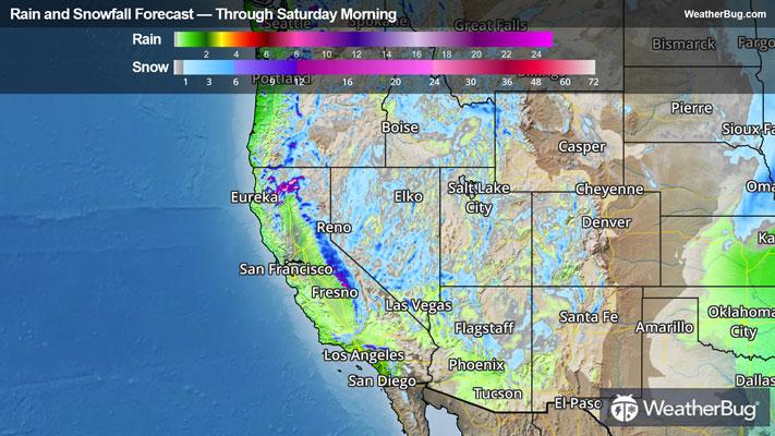
The western U.S. is at the mercy of a crawling low pressure system through today, which will then push east by late this evening into Saturday. This storm continues to be fed by warm air from the Pacific clashing with the cool air over the Rockies. As a result, widespread heavy rain and monumental mountain snow will pile up through the end of the work week.
Blizzard Warnings are in place for the Eastern Sierra Nevada, with Winter Storm Warnings stretching the length of the western slopes of the Sierra, as well as the mountains of southern California. Winter Weather Advisories extend across thesouthern California into Nevada, central Utah, northwestern and central Arizona. Additional Winter Storm Warnings and Winter Weather Advisories are in effect for portions of Idaho and southwestern Montana.
Additional rounds of heavy snow are expected to pummel over the mountains and higher elevations of the West Coast and could lead to dangerous accumulations. Two to 5 feet of fresh powder are possible with the highest mountain passes receiving upwards of 100 inches of snow by the afternoon.
In addition to the piles of snow, heavy rain will continue soak the Oregon coast, the northern and central California coast and the Central Valley in California. Moving forward, the fresh downpours will be spreading southward into southern California and the Desert Southwest Friday. Rainfall totals of up to 6 inches will be found from the Oregon coast into the lower elevations of northern and central California. A few isolated amounts up to 8 inches also cannot be ruled out. For southern California and the Desert Southwest, rainfall totals of 1 to 3 inches will be possible. Flash Flood Watches are scattered along the California coast into the Central Valley.
The rain will be accompanied by high winds up to 35 mph with gusts up to 45 mph. This is strong enough to topple trees and power lines leading to power outages.
Lesser amounts in the 1 to 2 feet range will be common across the Cascades, southern California mountains and the Intermountain regions from Washington and Oregon into Idaho, western Montana and northwestern Wyoming.
Heavy snow and rain have already been recorded across parts of the Golden State. As of Wednesday night, 32 inches of snow had been recorded in Tuolumne Meadows, Calif., up to 45 inches around Mammoth Mountain, Calif., and 33 inches at Lake Tahoe, Calif. In addition, Los Gatos and Redwood City, Calif., had received 3.29 inches of rain and 2.49 inches of rain, respectively. There have been reports of debris flows and flooded roadways across Santa Cruz and Fresno, Calif., and a downed tree in Merced, Calif., yesterday.
The next period of dry weather for California and the West Coast will occur later today into early Saturday, but a new system taking a northern path will bring rain and snow to northern California and the Northwest later on Saturday.
Heavy snow and high winds could potentially trigger power outages and long periods stuck in the house. It is important to have an emergency kit prepared should you be stranded for an unseeable amount of time. A simple kit comprised of non-perishable food items, blankets, water, batteries, and a radio could go a long way in remaining safe when calamity strikes. Remember to download the WeatherBug app to stay up to date on the latest.