Back to forecast
Major Winter Storm Bringing Snow Over Rockies, High Plains
December 14, 2023 at 05:24 PM EST
By WeatherBug Meteorologist, Alyssa Robinette
While we continue to inch closer to the "official" start of winter, Mother Nature plans to deliver a major winter storm to parts of the Rockies and High Plains. The highest elevations will be digging out of almost 2 feet of snow!
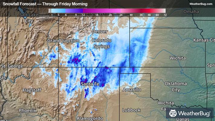
An upper-level low will move over the southern and central Rockies today and will move over the Plains on Friday. While there is not a significant amount of cold air associated with this system, there will be enough cold air and plenty of moisture in place to fuel widespread snow showers throughout the central and southern Rockies, the Front Range and parts of the High Plains.
Rain will mix with and change over to snow across western Kansas and the Oklahoma and Texas panhandles this afternoon. There will then be a period of light to moderate snow in the evening, but then snow will likely transition back over to rain overnight. Light to briefly moderate snow will also continue across northeastern New Mexico and southeastern Colorado.
When all is said and done, the Sangre de Cristo Mountains into the San Andres Mountains of southern Colorado and New Mexico will end up with 1 to 2 feet of snow! The San Juan Mountains of southwestern Colorado and the Raton Mesa along the Colorado/New Mexico border as well as the rest of the highest elevations of northern New Mexico will pick up 6 to 12 inches of fresh powder. Expect mainly 3 to 6 inches across southern and southeastern Colorado, the northern two-thirds of New Mexico and the Texas and Oklahoma panhandles. The rest of Colorado, western Kansas and southeastern Wyoming could see anywhere from a Trace to several inches of snow.
Winter Storm Warnings and Winter Weather Advisories are in effect across northeastern New Mexico, southwestern Kansas, as well as the Texas and Oklahoma panhandles. This includes Taos and Raton, N.M., Goodland, Kan., Boise City, Okla., and Dalhart, Texas.
Travel will be difficult to impossible where the highest snowfall occurs, with road closures possible and significant travel delays expected. This includes much of the Interstate 25 corridor in northeastern New Mexico, including Raton Pass. There will be icy, snow-packed roads and poor visibility.
By Friday, temperatures will likely be too warm for any wintry precipitation. Expect rain showers across the central and southern Plains into the Lower Mississippi Valley.
It’s never too early to have a supply kit packed in case of inclement weather. A simple kit including a weather radio, water, blankets, batteries, and non-perishable food items will go a long way in the event of a power outage. It’s always best to avoid travel in rough weather as the roads will be dangerous.