Back to forecast
Winter Storm Wreaks Havoc on Populated I-95 Corridor
January 19, 2025 at 05:38 AM EST
By WeatherBug Meteorologist, Alyssa Robinette
A fast-moving winter storm will dart across the Eastern U.S. for the end of the weekend, dropping piles of snow in the Mid-Atlantic and Northeast. It will cause plenty of problems on the heavily populated Interstate 95 corridor from Washington D.C. to Boston.
A cold front will be draped over the Eastern Seaboard today, while a low pressure system develops along this cold front and moves northeastward from the Carolina and Mid-Atlantic coastline. The cold front will draw bitter cold, Arctic air southward, with the low pressure transporting moisture from the Gulf of Mexico and Atlantic Ocean northward. The collision of extremely cold air and plenty of moisture will produce bursts of heavy snowfall along and west of Interstate 95 from Washington, D.C. to Boston.
While there could be some rain or mixed showers closer to the coast into early afternoon, this will quickly change over to snow. Rounds of snow will then be found throughout the Mid-Atlantic and Northeast for the rest of today. Snow will taper off and end from southwest-to-northeast early Monday morning.
Winter Storm Warnings are in effect from western North Carolina, far eastern Kentucky and West Virginia into Maryland, southeastern Pennsylvania, northern New Jersey and southern New England. This includes Philadelphia and Boston. Winter Weather Advisories surround these areas from central Appalachia into the Mid-Atlantic and northern New England, which includes Washington, D.C., Baltimore and New York City.
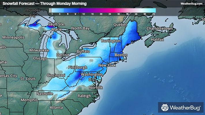
A general 2 to 4 inches will be common from the Mid-Atlantic into southern and eastern portions of New England, including Washington, D.C., and New York City itself. Locally higher snowfall amounts of 4 to 6 inches will likely blanket a few areas, including Philadelphia, the western/northern suburbs of New York City and Boston. A few spots in the Appalachian and the higher elevations of New England could see stubborn bands of heavy snow, potentially picking up 6 to 10 inches of fresh powder.
In the wake of this storm, a significant Arctic blast will move into the East, producing some of the coldest temperatures seen in years for the East.
Be sure to download the WeatherBug app to stay up to date on the latest on this changing weather. Regardless of the exact track, it’s never too early to have a supply kit packed in case of inclement weather. A simple kit including a weather radio, water, blankets, batteries and non-perishable food items will go a long way in the event of a power outage. It’s always best to avoid travelling in rough weather as the roads will be dangerous.
A cold front will be draped over the Eastern Seaboard today, while a low pressure system develops along this cold front and moves northeastward from the Carolina and Mid-Atlantic coastline. The cold front will draw bitter cold, Arctic air southward, with the low pressure transporting moisture from the Gulf of Mexico and Atlantic Ocean northward. The collision of extremely cold air and plenty of moisture will produce bursts of heavy snowfall along and west of Interstate 95 from Washington, D.C. to Boston.
While there could be some rain or mixed showers closer to the coast into early afternoon, this will quickly change over to snow. Rounds of snow will then be found throughout the Mid-Atlantic and Northeast for the rest of today. Snow will taper off and end from southwest-to-northeast early Monday morning.
Winter Storm Warnings are in effect from western North Carolina, far eastern Kentucky and West Virginia into Maryland, southeastern Pennsylvania, northern New Jersey and southern New England. This includes Philadelphia and Boston. Winter Weather Advisories surround these areas from central Appalachia into the Mid-Atlantic and northern New England, which includes Washington, D.C., Baltimore and New York City.
A general 2 to 4 inches will be common from the Mid-Atlantic into southern and eastern portions of New England, including Washington, D.C., and New York City itself. Locally higher snowfall amounts of 4 to 6 inches will likely blanket a few areas, including Philadelphia, the western/northern suburbs of New York City and Boston. A few spots in the Appalachian and the higher elevations of New England could see stubborn bands of heavy snow, potentially picking up 6 to 10 inches of fresh powder.
In the wake of this storm, a significant Arctic blast will move into the East, producing some of the coldest temperatures seen in years for the East.
Be sure to download the WeatherBug app to stay up to date on the latest on this changing weather. Regardless of the exact track, it’s never too early to have a supply kit packed in case of inclement weather. A simple kit including a weather radio, water, blankets, batteries and non-perishable food items will go a long way in the event of a power outage. It’s always best to avoid travelling in rough weather as the roads will be dangerous.