Wintry Weather Targets Interior Northeast Early Today
The coastal low pressure system that has brought plenty of trouble to the East over the past several days will finally move away from the U.S. today. However, it will squeeze out a wintry mess in the Northeast before it goes.
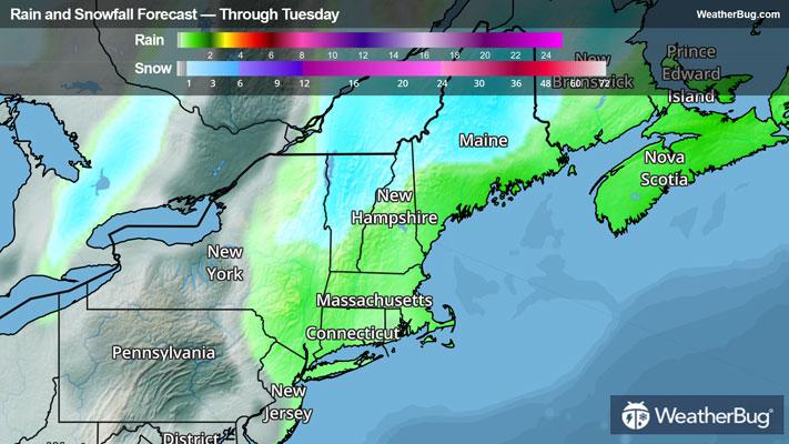
The storm is currently located close to Nova Scotia and moving to the east but its impacts are still being felt throughout the Northeast. Soaking rain will continue along the Interstate 95 corridor from Connecticut to Maine through mid to late morning, before coming to an end by midday. Farther north, a wintry mix of snow, freezing rain and rain remain in the forecast through later this afternoon and evening from eastern New York and the upper Hudson Valley into northern Maine. This includes Massachusetts’ western Berkshires, New York’s Adirondacks, Vermont’s Green and New Hampshire’s White mountains.
Winter Weather Advisories are in effect through early afternoon, which stretch from eastern New York northeastward through northern Maine. This includes Utica and Great Falls, N.Y., Burlington, Vt, Conway, N.H., and Millinocket and Caribou, Maine.
Snow totals ranging from 2 to 4 inches will be possible from New York’s Adirondack and Vermont’s Green Mountains to northwestern Maine, including cities like Plattsburgh, N.Y., Burlington and Montpelier, Vt., as well as Caribou, Maine. Many of these same locations will be scraping away more than one-tenth inch of ice accumulation, though slippery travel could develop as far east as the Interstate 95 corridor of coastal Maine.
Gusty winds will still be possible across coastal New England today, with wind gusts of 30 to 40 mph. This could lead to localized power outages, minor storm surge and battering waves. Coastal flooding and minor beach erosion will also be possible.