Back to forecast
Eastern U.S. Locked in Soggy, Snowy Weather Pattern
January 29, 2024 at 01:02 AM EST
By WeatherBug Meteorologist, Fred Allen
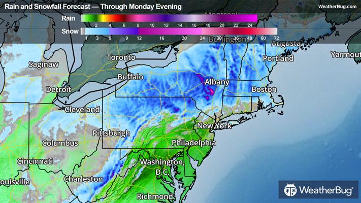
Areas of locally heavy rain are possible across parts of the Mid-Atlantic tonight while snow will continue across much of the New England through Monday morning as a late January storm system pushes offshore.
Moisture on the northern fringe of the storm will fall in near or largely sub-freezing air, which means a gloppy, wet snow will accumulate along and near the Interstate 90 corridor snaking through New York State and New England on tonight through the first half of Monday. The heaviest snowfall totals will likely occur in southwestern New York, near New York’s Catskills, the western Berkshires and hills across Worcester, Mass., as well as across higher terrain such as the Monadnocks in southern New Hampshire and southern Green Mountains in Vermont.
Already, Winter Storm Warnings, Winter Weather Advisories, and Winter Storm Watches are in effect across parts of New York and Pennsylvania, southern Vermont and New Hampshire, southern Massachusetts, western Connecticut, and along the North Carolina-Tennessee border. Several inches of snowfall accumulation are likely in these areas. At least a couple inches of snow could lead to slippery travel as far north as Downeast Maine, and as far west and south as northern Ohio and along the central and southern Appalachian Spine through Monday. Sustained winds of 15 to 30 mph with gusts near 40 to 50 mph will also be commonplace in parts of the Carolinas and Georgia where Wind Advisories are in place.
In addition to travel headaches, the wet consistency of the snow could lead to potential scattered power outages, particularly at elevations above 1,000 feet where up to 8 to 10 inches could blanket the ground in central New York and in central New England by storm’s end. A bit of freezing rain may slicken up roads as well. If you cannot avoid traveling, allow plenty of time and distance between you and the next vehicle to arrive at your destination safely.