Back to forecast
Great Lakes, Midwest Brace For Early-Week Big Storms
February 27, 2024 at 11:38 PM EST
UPDATED By WeatherBug Meteorologists
Powerful thunderstorms will rattle much of the Lower Great Lakes into Ohio and Middle Mississippi valleys tonight into Wednesday morning. The full gauntlet of severe hazards will be on the weather menu.
Low pressure will race from southern Minnesota to the western shores of Lake Huron throughout today. Unseasonably warm, notably more humid will be tugged northward in the storm’s warm sector throughout today. At the same time, a potent upper-level disturbance will race over the northern Plains to the Upper Midwest. These two big pieces of the forecast puzzle will likely culminate in a short-fused, intense thunderstorm outbreak.
Thunderstorms will initially develop along the intersection of the warm and cold fronts draped from near southern Wisconsin and Michigan to southern Missouri near or shortly after sunset. Multiplying over time, then likely merging into several clusters or lines through predawn on Wednesday, the activity may contain large, damaging hail, high winds, and a few tornadoes. The best chance for a tornado to occur would be near the warm front, as well as at the beginning in advance of the cold front.
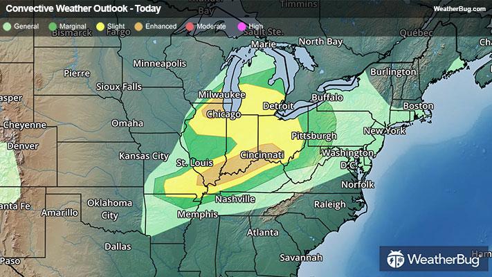
The government’s Storm Prediction Center has issued an Enhanced Risk for severe weather for two areas. One stretches across northeastern Illinois, while the second is found from southern Illinois and western Kentucky into southern Indiana and southwestern Ohio. This includes Rockford and Aurora, Ill., Louisville, Ky., and Cincinnati and Dayton, Ohio. A Tornado Watch is in effect for southern Illinois, southern Indiana (including Indianapolis), northern Kentucky (including Paducah and Louisville), and southwestern Ohio (including Dayton). In north-central and northeast Indiana, southern Michigan, and extreme northwestern Ohio, a Severe Thunderstorm Watch is in effect.
However, anyone from the Lower Great Lakes and Midwest into the Ohio Valley should be prepared for dangerous thunderstorms. This includes Chicago and Peoria, Ill., Springfield, Mo., Milwaukee, Wis., Detroit, St. Louis, Bowling Green, Ky., Columbus, Ohio, and Pittsburgh.
Severe weather won’t be the only impactful issue either. Heavy rain falling in such a short time may lead to poor drainage urban flooding. Locally up to an inch or more will be possible. If a roadway is covered in water, remember a simple motto – “Turn Around, Don’t Drown!”
Make sure to frequently check WeatherBug for updates, as a watch can quickly turn into a warning upon imminent danger. Make sure to understand the difference between a watch and a warning should they be issued. A watch means that conditions are favorable for severe weather to occur and to be on alert for any rapidly changing conditions. A warning means that severe weather is imminent, and you should act fast to remain safe.
The best way to remain safe is to stay prepared and informed about your local weather. Have a severe weather kit packed with a battery-operated radio, water and non-perishable food items should you be without power for long periods of time. Also, check the WeatherBug app frequently for any updates on today’s severe weather. Remember, “When Thunder Roars, Go Indoors!”
Low pressure will race from southern Minnesota to the western shores of Lake Huron throughout today. Unseasonably warm, notably more humid will be tugged northward in the storm’s warm sector throughout today. At the same time, a potent upper-level disturbance will race over the northern Plains to the Upper Midwest. These two big pieces of the forecast puzzle will likely culminate in a short-fused, intense thunderstorm outbreak.
Thunderstorms will initially develop along the intersection of the warm and cold fronts draped from near southern Wisconsin and Michigan to southern Missouri near or shortly after sunset. Multiplying over time, then likely merging into several clusters or lines through predawn on Wednesday, the activity may contain large, damaging hail, high winds, and a few tornadoes. The best chance for a tornado to occur would be near the warm front, as well as at the beginning in advance of the cold front.
The government’s Storm Prediction Center has issued an Enhanced Risk for severe weather for two areas. One stretches across northeastern Illinois, while the second is found from southern Illinois and western Kentucky into southern Indiana and southwestern Ohio. This includes Rockford and Aurora, Ill., Louisville, Ky., and Cincinnati and Dayton, Ohio. A Tornado Watch is in effect for southern Illinois, southern Indiana (including Indianapolis), northern Kentucky (including Paducah and Louisville), and southwestern Ohio (including Dayton). In north-central and northeast Indiana, southern Michigan, and extreme northwestern Ohio, a Severe Thunderstorm Watch is in effect.
However, anyone from the Lower Great Lakes and Midwest into the Ohio Valley should be prepared for dangerous thunderstorms. This includes Chicago and Peoria, Ill., Springfield, Mo., Milwaukee, Wis., Detroit, St. Louis, Bowling Green, Ky., Columbus, Ohio, and Pittsburgh.
Severe weather won’t be the only impactful issue either. Heavy rain falling in such a short time may lead to poor drainage urban flooding. Locally up to an inch or more will be possible. If a roadway is covered in water, remember a simple motto – “Turn Around, Don’t Drown!”
Make sure to frequently check WeatherBug for updates, as a watch can quickly turn into a warning upon imminent danger. Make sure to understand the difference between a watch and a warning should they be issued. A watch means that conditions are favorable for severe weather to occur and to be on alert for any rapidly changing conditions. A warning means that severe weather is imminent, and you should act fast to remain safe.
The best way to remain safe is to stay prepared and informed about your local weather. Have a severe weather kit packed with a battery-operated radio, water and non-perishable food items should you be without power for long periods of time. Also, check the WeatherBug app frequently for any updates on today’s severe weather. Remember, “When Thunder Roars, Go Indoors!”