Back to forecast
Severe Storms Dot The Eastern U.S., Rockies
August 6, 2024 at 07:18 PM EDT
By WeatherBug Meteorologist, Mark Ellinwood
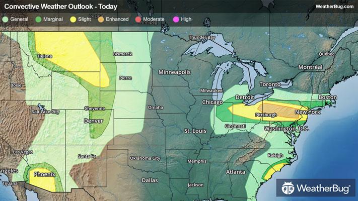
A multitude of disturbances will bring several pockets of severe storms to the U.S. today. Storms will be concentrated over the Rockies, High Plains, Ohio Valley, Mid-Atlantic, and the eastern Carolinas.
Storms in the Rockies and High Plains will be triggered by a pair of upper-level disturbances moving through the northern Rockies and southwestern U.S. this afternoon and evening. Tapping into plenty of heat and monsoonal moisture, these storms could produce gusty winds and hail.
Phoenix and Tucson, Ariz., Great Falls, Glasgow, and Billings, Mont., and Rapid City, S.D. are all under a Slight Risk for severe storms today.
Severe Thunderstorm Watches have been issued for north-central and southeastern Montana, western South Dakota and northeastern Wyoming. Cities affected include Rapid City, S.D., Gillette, Wyo., and Billings, Kalispell, and Helena, Mont.
A cold front will continue to drop southward across the Ohio Valley and Mid-Atlantic today. Hot and humid air in place near the front will fuel scattered to widespread thunderstorm activity this morning through this evening. an Enhanced Risk (a 3 out of 5 on the government's severe storm threat scale) is present from far northeastern Ohio through just west of New Jersey. Additionally, there is an enveloping Slight Risk for these storms that covers much of Ohio, Pennsylvania, and New Jersey. Severe damaging winds and some hail are possible, along with a chance for a few tornadoes. Storms could also produce localized flash flooding, with a quick 1 to 2 inches of rain possible in some areas.
A Severe Thunderstorm Watch is in effect from eastern Ohio into most New Jersey. This includes Philadelphia, and Scranton Pa., and Newark, N.J.
Tropical Storm Debby also brings a Slight Risk to parts of the eastern Carolinas throughout today and tonight. These storms could contain gusty winds and a few tornadoes.
A Tornado Watch for these storms is in effect along the Carolina coastlines, affecting cities such as Wilmington and Jacksonville, N.C. as well as Myrtle Beach, and Florence, S.C.
Have a severe weather plan in place in case severe weather strikes your area. Remember, "When Thunder Roars, Stay Indoors!"