Back to forecast
Storms Light Up The Central Plains, Midwest
July 2, 2024 at 11:14 PM EDT
By WeatherBug Meteorologist, Mark Ellinwood
Another round of severe thunderstorms is expected to hit the central U.S. through later tonight.
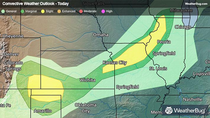
An upper-level weather disturbance will move across the nation’s midsection today, making its way from the central Rockies to the western Midwest. This system will be the main driver of new severe storms as it collides with a warm and humid air mass.
The Storm Prediction Center has issued Slight Risks that stretch from Iowa and northern Missouri southwestward through Kansas, southeastern Colorado, and the Oklahoma Panhandle. The best chance for severe storms will be across southern Iowa, northern Missouri, and northeastern Kansas.
Damaging wind gusts will be the main threats with storms that form today and tonight. Some storms could also produce hail and perhaps a few tornadoes.
A Severe Thunderstorm Watch are in effect for portions of Missouri and Illinois, including Kansas City, Mo. and Peoria, Ill.
As these storms progress eastward overnight, they will work into Wisconsin and Illinois, where they should gradually weaken. Another round of storms will form Wednesday afternoon and evening, covering the Lower Midwest, Ohio Valley, and much of the northern and central Plains.
Make sure to frequently check WeatherBug for updates, as a watch can quickly turn into a warning upon imminent danger. It is important to stay prepared for active weather. Make sure you know the difference between a watch and a warning should they become issued. A watch means that conditions are favorable for severe weather to take place, whereas a warning means severe weather is imminent and you need to act fast to prevent damage to property or even loss of life. Remember, “When Thunder Roars, Go Indoors!”