Today's Weather Outlook
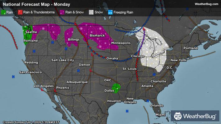
Snow and rain impact the northern half of the nation today, while the work week begins with a drier pattern for most.
In the Northeast, dry conditions persist throughout the day. Most will enjoy dry weather throughout the day, but the areas bordering the Great Lakes can see isolated snowfall.
Similarly for the Midwest, snowfall will be segregated to the Great Lakes region, trailing down the Ohio River Valley. There will also be a rain/snow mix among the northern Plains primarily in the Dakotas, but the remainder of the Midwest should be dry.
High pressure allows for dry conditions in the Deep South and Southeast. There will be some isolated rain showers where Oklahoma, Arkansas, Texas, and Louisiana meet, but the remainder of the South will be dry.
The Mountain West is also fortunate for dry conditions to start the work week, with the only areas at risk for a rain/snow mix being Montana and Idaho. Within these areas, the precipitation should mostly stick to the higher elevations within the mountains.
The Desert Southwest will continue to experience dry weather conditions, with no precipitation expected within the area.
The Pacific Northwest will experience mostly dry conditions; however, the coastal regions of Washington and northwest Oregon will see rainfall. A rain and snow mix will cling to the Cascades, bringing snow to mountain peaks and cold rain to the foothills.
Unlike the recent wave of chilly weather this past week, the work week is off to a less-chilly start with areas in the teens being the U.S.-Canada border in North Dakota, Minnesota, Michigan’s Upper Peninsula, and the border along New England.
Areas in the 20s will be the Great Lakes region and most of the Northeast, with exception to coastal areas. The high peaks within the Rockies will also see temperatures in the 20s. Thirties are in store for the Mid-Atlantic, the Northeastern coastline, eastern Nebraska, northern Iowa, southern Illinois, and Kentucky. Forties will be present in the northern Rockies, the Cascades, and the Tennessee Valley.
Fifties are in store for a majority of the country today. Florida, Georgia, Alabama, northern Mississippi, Arkansas, northeastern Oklahoma, Kansas, western Nebraska, and the lowland areas within the northern Rockies. Apart from this swath of 50-degree temperatures, the Pacific Northwest will be in the 50s, as well as the Great Basin Desert.
Texas, Oklahoma, the Desert Southwest, and California’s Central Valley will primarily see temperatures in the 60s, while the Rio Grande Valley and arid regions within the Desert Southwest should see 70s.