Back to forecast
Disruptive Snow, Ice Impacting Ohio Valley to Southeast
January 11, 2025 at 12:23 AM EST
Update By WeatherBug Meteorologist, Rob Miller
Mother Nature continues to unleash her fury across parts of the Ohio Valley to Mid-Atlantic and Southeast, with snow, ice, and rain to close out the work week.
An area of low pressure will move eastward across the Southeast this evening and tonight. Cold air continues to funnel southward toward this low pressure system, with is colliding with plenty of warm, moist air moving northward out of the Gulf of Mexico. The clash of these two distinct air masses will result in a winter storm across the Ohio Valley to Mid-Atlantic and Southeast, capable of bringing travel to a standstill.
Moderate to briefly heavy snow will continue to move across the eastern Tennessee Valley this evening, with rain, snow, and even ice found from northern Alabama eastward into northern Georgia. A wintry mix of snow, sleet, and ice will continue this evening across the Carolinas.
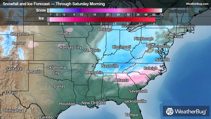
Winter Storm Warnings stretch from northern Georgia, the Tennessee and Ohio valleys, southern Appalachians, and into the Carolinas through southern Virginia. This includes cities such as Lexington, Ky., Atlanta, Charlotte and Raleigh, N.C., and Richmond, Va.
Winter Weather Advisories surround these warnings and stretch across Michigan, Ohio, West Virginia, the eastern Carolinas through northern Virginia to southern Maryland and Delaware, and parts of the Carolinas. Cities such as Cincinnati, Indianapolis, Detroit, Pittsburgh and Washington D.C., are included.
Within the warning areas, snow accumulations of 2 to 5 inches will be common, while locally 5 to 7 inches of snow will be possible in parts Tennessee and southern Kentucky. Farther to the east, snow accumulations will be lighter in the southern Appalachians into the Carolinas, with a general 1 to 3 inches of snow. But here, sleet and even freezing rain will mix with the snow, with upwards of 0.15 inches of ice possible. Locally higher ice amounts will be possible this evening, especially from near Raleigh and Charlotte, N.C., to Columbia, S.C., to Atlanta where locally up to 0.25 inches of ice will be possible.
Meanwhile, moderate to locally heavy rainfall will occur from Alabama eastward into Georgia. Rainfall totals of 1 to as much as 3 inches will be possible, which may lead to localized flooding in urban areas and in poor drainage areas. Remember, “Turn Around, Don’t Drown!” if you approach a flooded roadway. While a few embedded thunderstorms will also be possible today, widespread severe weather is not anticipated at this time.
Moisture from this system will also be pulled northward tonight into Saturday as an arctic cold front sweeps across the Great Lakes, Ohio Valley, and into the Mid-Atlantic and Northeast. Along and ahead of this front, light snow is expected by Saturday morning. Here, snow accumulations will generally be under 2 inches, but localized snow accumulations of 3 or 4 inches will be possible in the Ohio Valley into the Appalachian mountains of Pennsylvania and West Virginia.
Be sure to download the WeatherBug app to stay up to date on the latest on this changing weather. Regardless of the exact track, it’s never too early to have a supply kit packed in case of inclement weather. A simple kit including a weather radio, water, blankets, batteries and non-perishable food items will go a long way in the event of a power outage. It’s always best to avoid travelling in rough weather as the roads will be dangerous.
An area of low pressure will move eastward across the Southeast this evening and tonight. Cold air continues to funnel southward toward this low pressure system, with is colliding with plenty of warm, moist air moving northward out of the Gulf of Mexico. The clash of these two distinct air masses will result in a winter storm across the Ohio Valley to Mid-Atlantic and Southeast, capable of bringing travel to a standstill.
Moderate to briefly heavy snow will continue to move across the eastern Tennessee Valley this evening, with rain, snow, and even ice found from northern Alabama eastward into northern Georgia. A wintry mix of snow, sleet, and ice will continue this evening across the Carolinas.
Winter Storm Warnings stretch from northern Georgia, the Tennessee and Ohio valleys, southern Appalachians, and into the Carolinas through southern Virginia. This includes cities such as Lexington, Ky., Atlanta, Charlotte and Raleigh, N.C., and Richmond, Va.
Winter Weather Advisories surround these warnings and stretch across Michigan, Ohio, West Virginia, the eastern Carolinas through northern Virginia to southern Maryland and Delaware, and parts of the Carolinas. Cities such as Cincinnati, Indianapolis, Detroit, Pittsburgh and Washington D.C., are included.
Within the warning areas, snow accumulations of 2 to 5 inches will be common, while locally 5 to 7 inches of snow will be possible in parts Tennessee and southern Kentucky. Farther to the east, snow accumulations will be lighter in the southern Appalachians into the Carolinas, with a general 1 to 3 inches of snow. But here, sleet and even freezing rain will mix with the snow, with upwards of 0.15 inches of ice possible. Locally higher ice amounts will be possible this evening, especially from near Raleigh and Charlotte, N.C., to Columbia, S.C., to Atlanta where locally up to 0.25 inches of ice will be possible.
Meanwhile, moderate to locally heavy rainfall will occur from Alabama eastward into Georgia. Rainfall totals of 1 to as much as 3 inches will be possible, which may lead to localized flooding in urban areas and in poor drainage areas. Remember, “Turn Around, Don’t Drown!” if you approach a flooded roadway. While a few embedded thunderstorms will also be possible today, widespread severe weather is not anticipated at this time.
Moisture from this system will also be pulled northward tonight into Saturday as an arctic cold front sweeps across the Great Lakes, Ohio Valley, and into the Mid-Atlantic and Northeast. Along and ahead of this front, light snow is expected by Saturday morning. Here, snow accumulations will generally be under 2 inches, but localized snow accumulations of 3 or 4 inches will be possible in the Ohio Valley into the Appalachian mountains of Pennsylvania and West Virginia.
Be sure to download the WeatherBug app to stay up to date on the latest on this changing weather. Regardless of the exact track, it’s never too early to have a supply kit packed in case of inclement weather. A simple kit including a weather radio, water, blankets, batteries and non-perishable food items will go a long way in the event of a power outage. It’s always best to avoid travelling in rough weather as the roads will be dangerous.