Back to forecast
Rounds of Wintry Weather Target Great Lakes, Northeast
November 26, 2024 at 03:23 PM EST
By WeatherBug Meteorologist, Alyssa Robinette
Multiple weather systems will wreak havoc on the Great Lakes and parts of the Northeast into early next week, creating plenty of wintry weather and travel headaches for some of the busiest travel days of the year.
A low pressure system will be gliding from the Great Lakes into southeastern Canada, while a second area of low pressure develops over southern New England. There will also be a cold front associated with both low pressure systems that pushes across the Eastern Seaboard but gets hung up over the northern peninsula of Florida. The cold front will also tap into moisture from the Gulf of Mexico and transport it northward.
Thankfully, if you are travelling for Thanksgiving, any wintry precipitation will be limited to only a few areas. Northwesterly winds behind the low pressure system will crank up lake-effect snow for areas south and east of the Great Lakes, especially for northern Michigan and Michigan’s Upper Peninsula. Generally light snowfall will be likely throughout the Upper Great Lakes today. However, moderate to heavy snow will be found in spots depending on wind direction and how it enhances the snow.
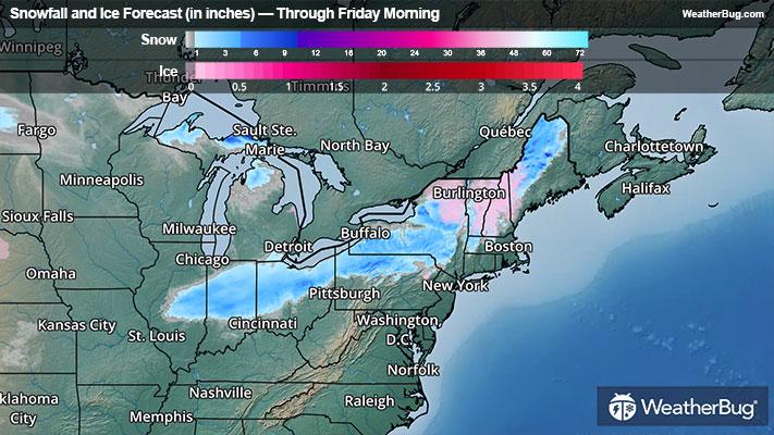
The other area to watch out for would be interior portions of the Northeast. Initially, temperatures will be cold enough at the surface for freezing rain to develop over northeastern New York, most of Vermont and New Hampshire and most of western Maine through the afternoon. Most areas will see this freezing rain change over to plain rain as warmer air moves in. It will remain cold enough over the northern half of Maine for the freezing rain to mix with and change over to snow and sleet.
Snowfall accumulations across the Upper Great Lakes will generally range from a Trace to 2 inches. Though, any area that sees enhanced lake-effect snow will see around 2 to 6 inches of snow pile up. Meanwhile, the interior Northeast could see up to an inch of snow or sleet. Ice amounts will range from a Trace up to one-tenth inch.
Winter Weather Advisories stretch across Michigan’s Upper Peninsula, which includes Houghton, Maine. Additional Winter Weather Advisories are in effect for northeastern New York, all of Vermont, most of New Hampshire and northwestern Maine.
A new storm system currently impacting the Western U.S. will dart across the Midwest, Ohio Valley and Northeast Wednesday into Thanksgiving Day. Most areas along and east of the Mississippi will just see rain. Temperatures, however, could be cold enough for another round of wintry precipitation near the Great Lakes and the interior Northeast.
Once this system moves out, a long-duration lake-effect snow even will set up for Friday into the start of next week. Already, Winter Storm Watches have been issued for parts of western New York, including Jamestown and Watertown, N.Y.
With wintry weather expected across the nation leading up to Thanksgiving, be sure to have a supply kit packed in case of inclement weather. A simple kit, including a weather radio, water, blankets, batteries and non-perishable food items will go a long way in the event of a power outage or being caught in a winter storm while driving. It’s always best to avoid traveling in rough weather as the roads will be dangerous.
A low pressure system will be gliding from the Great Lakes into southeastern Canada, while a second area of low pressure develops over southern New England. There will also be a cold front associated with both low pressure systems that pushes across the Eastern Seaboard but gets hung up over the northern peninsula of Florida. The cold front will also tap into moisture from the Gulf of Mexico and transport it northward.
Thankfully, if you are travelling for Thanksgiving, any wintry precipitation will be limited to only a few areas. Northwesterly winds behind the low pressure system will crank up lake-effect snow for areas south and east of the Great Lakes, especially for northern Michigan and Michigan’s Upper Peninsula. Generally light snowfall will be likely throughout the Upper Great Lakes today. However, moderate to heavy snow will be found in spots depending on wind direction and how it enhances the snow.
The other area to watch out for would be interior portions of the Northeast. Initially, temperatures will be cold enough at the surface for freezing rain to develop over northeastern New York, most of Vermont and New Hampshire and most of western Maine through the afternoon. Most areas will see this freezing rain change over to plain rain as warmer air moves in. It will remain cold enough over the northern half of Maine for the freezing rain to mix with and change over to snow and sleet.
Snowfall accumulations across the Upper Great Lakes will generally range from a Trace to 2 inches. Though, any area that sees enhanced lake-effect snow will see around 2 to 6 inches of snow pile up. Meanwhile, the interior Northeast could see up to an inch of snow or sleet. Ice amounts will range from a Trace up to one-tenth inch.
Winter Weather Advisories stretch across Michigan’s Upper Peninsula, which includes Houghton, Maine. Additional Winter Weather Advisories are in effect for northeastern New York, all of Vermont, most of New Hampshire and northwestern Maine.
A new storm system currently impacting the Western U.S. will dart across the Midwest, Ohio Valley and Northeast Wednesday into Thanksgiving Day. Most areas along and east of the Mississippi will just see rain. Temperatures, however, could be cold enough for another round of wintry precipitation near the Great Lakes and the interior Northeast.
Once this system moves out, a long-duration lake-effect snow even will set up for Friday into the start of next week. Already, Winter Storm Watches have been issued for parts of western New York, including Jamestown and Watertown, N.Y.
With wintry weather expected across the nation leading up to Thanksgiving, be sure to have a supply kit packed in case of inclement weather. A simple kit, including a weather radio, water, blankets, batteries and non-perishable food items will go a long way in the event of a power outage or being caught in a winter storm while driving. It’s always best to avoid traveling in rough weather as the roads will be dangerous.