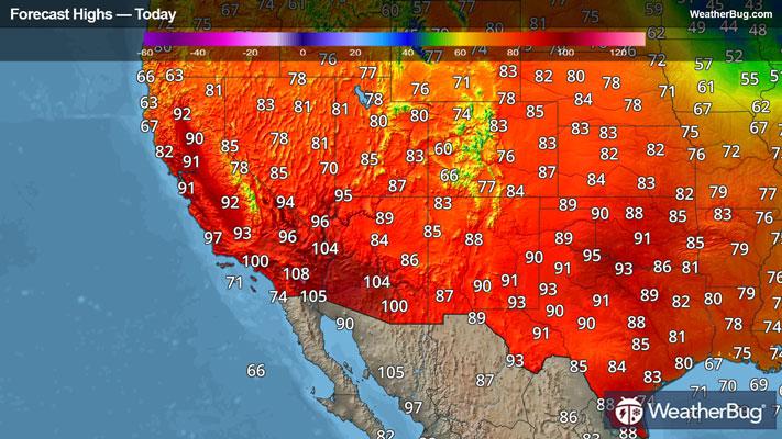
Severe thunderstorms will form across the High Plains today to end this weekend, but it is the beginning of the workweek where a particularly ominous storm threatens the Northern Plains and Upper Midwest.
Today, unsettled weather will shift into the High Plains with a large area of Slight Risk (a 2 out of 5 risk) for severe thunderstorms. Upper-level energy will be the instigator for this potential for severe thunderstorms, causing thunderstorms to form this afternoon. Although an isolated tornado is possible, large hail and damaging winds are the greatest weather hazards today.
Currently, there is a Slight Risk area posted for western Texas northward into central Nebraska and into southern North Dakota, threatening locales such as Bismarck and Dickinson, N.D., Pierre, S.D., and both North Platte and Kearney, Neb.
The most ominous outlook, however, is expected for Monday. A significant potential for a tornado outbreak is on the horizon for the far Upper Midwest, with additional destructive storms possible all the way into Texas. High-energy and moisture-laden air cross a strong front over the U.S. Midsection to shoot up supercells and severe storm lines alike from midday on Monday through the night. Storms producing very large hail and destructive wind gusts are also on the radar under this strong concoction of severe weather ingredients.
The most unstable conditions will pair with the Upper Midwest, where there is already a Moderate Risk (a 4 out of 5 risk) for the heart of the Upper Midwest. Major cities such as St. Paul and Rochester, Minn., Des Moines and Cedar Rapids, Iowa, and La Crosse, Wis., are marked under this dangerous risk area.
An Enhanced Risk (a 3 out of 5 risk) and Slight Risk also encompass the threat, drooping as far north as the Canadian border into just south of the Texas Panhandle. A wide suite of cities is covered by these areas, including Minneapolis, Milwaukee, Wis., Kansas City, Mo., Chicago, and Oklahoma City to name a few.
Severe weather will not just stop in its tracks after Monday night. Severe storm systems are forecasted to sweep eastward as the workweek progresses, and risk levels are likely to change form and even increase or deepen. The best protection is staying informed through reliable sources like the WeatherBug app and having an emergency kit ready with essentials like water, non-perishable food, and a battery-powered radio. As always, heed the lifesaving advice: "When Thunder Roars, Go Indoors!"