
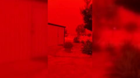
Monday's Weather Outlook
Unsettled weather interrupts the beginning of the work week for many across the Nation this Monday.
Read More
Weather Station:Grants Pass Airport 1100 ft elev
64degrees Fahrenheit
Feels like:64°F
Hi: 73Lo: 43
Partly Cloudy
Lo42°F
Mostly cloudy. A 10 percent chance of rain late this evening and overnight. Lows in the mid 30s to mid 40s. In the valleys north winds 5 to 10 mph. At higher elevations north winds 10 to 15 mph shifting to the northeast 5 to 10 mph well after midnight.
Hi63°F
Mostly cloudy. Slight chance of rain and snow in the morning then slight chance of rain in the afternoon. Snow level 3500 feet in the morning. Highs in the mid 50s to lower 60s. Northeast winds 5 to 10 mph shifting to the northwest late in the afternoon. Chance of precipitation 20 percent.
27 | Fair
10 High
Closest strike in the last 30 minutes:908.9 miles
No Lightning Nearby


