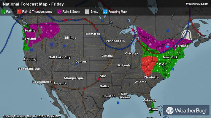
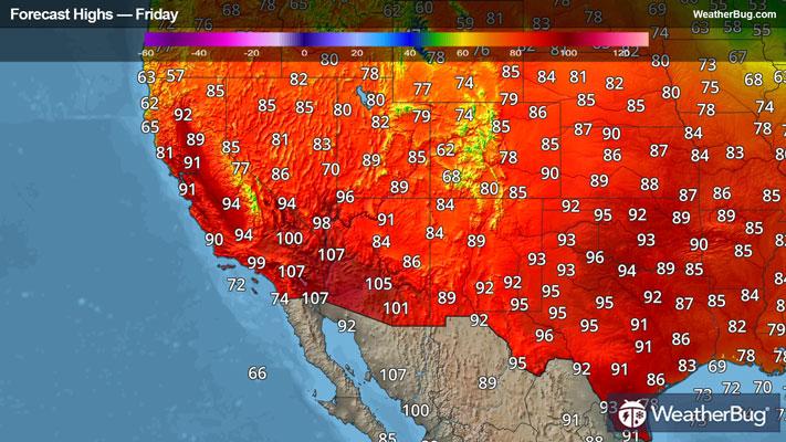
Groveton, NH Weather

As of

Weather Station:Mt Washington Arpt Whitefield 1060 ft elev

Open weather station selector modal

3degrees Fahrenheit

Feels like:3°F

Hi: 28Lo: 3

Mostly Cloudy

Live Weather Radar

Groveton, NH weather radar map

Current Weather Details

Windchill
Daily Rain
0"
Dew point
-2°
Monthly Rain
0.41"
Humidity
79%
Avg. Wind
N 0 mph
Pressure
29.65" →
Wind Gust
0 mph
Sunrise
6:30 AM
Moon
Waxing Gibbous
Sunset
5:28 PM
UV Index
-- (--)

Weather Forecast

  • Today

    Hi

    Mostly cloudy. Snow likely mainly this morning. Snow accumulation around an inch. Highs in the lower 30s. Southeast winds around 10 mph with gusts up to 20 mph this morning becoming light and variable. Chance of snow 70 percent. Wind chill values as low as 8 below this morning.

  • Tonight

    Lo

    Partly cloudy with a 20 percent chance of snow. Not as cold with lows around 14. Light and variable winds becoming west around 10 mph with gusts up to 20 mph after midnight.

Groveton, NH 10-day weather forecast

AIR QUALITY

18 | Excellent

Top Triggers:pm25
Air quality data provided by Ambee
View Today's Air Quality details for Groveton, NH

POLLEN COUNT & ALLERGY FORECAST

0.3 Low

Predominant Pollen:Mixed Trace
View the Pollen forecast details

LIGHTNING MAP

Closest strike in the last 30 minutes:2873.9 miles

No Lightning Nearby

Real-time lightning alerts & live Map