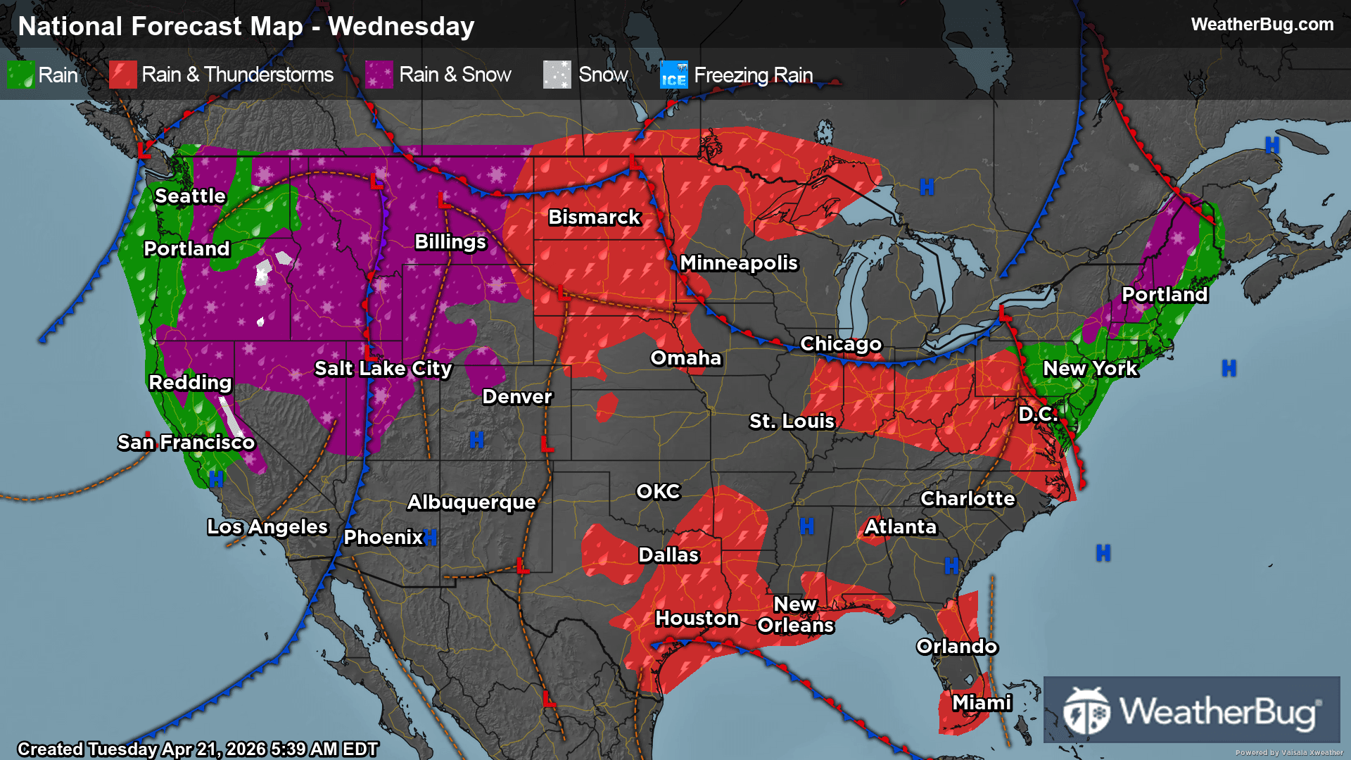
GroundTruthWeatherBug for Advertisers
  • Sign In
  • Press
  • Education
  • Feedback
  • Careers
  • Settings
  • Forecasts
  • Maps
  • Alerts
  • Life
  • News & Videos
  • Cameras
  • Air Quality
  • Hurricane
0
NowHourly10 Day
  • Today's Weather - Gyalóka, HUN

    Sep 23, 2025 3:24 AM
    LUTZMANNSBURG
    14°
    Weather forecast icon
    Feels like 14°
    Hi --
    Lo 14°C
    Mostly Cloudy
  • WEATHER FORECASTGyalóka, Győr-Moson-Sopron, HU
    • Windchill14°C
      Daily Rain--
    • Dew Point11°C
      Monthly Rain--
    • Humidity82%
      Avg. WindN 4 mph
    • Pressure--
      Wind Gust--
    • Sunrise6:40 AM
      MoonWaxing Crescent
    • Sunset6:49 PM
      UV Index3 (Moderate)
  • WEATHER FORECASTGyalóka, Győr-Moson-Sopron, HU
    TonightLo 16°C
    Weather forecast icon
    Partly cloudy. Low temperature around 61F. Dew point will be around 56F with an average humidity of 60%. Winds will be 4 mph from the N.
    TomorrowHi 18°C
    Cloudy with a slight chance of rain. Chance of precipitation 25%. High temperature around 64F. Dew point will be around 49F with an average humidity of 56%. Winds will be 7 mph from the N.
  • Featured Videos
  • Air Quality
    -- | --
    Top Triggers: --
    Air quality data provided by Ambee
  • POLLEN COUNT & ALLERGY FORECAST
    Failed to load
    Something went wrong loading the data. Please reload the page or try again later.
  • Lightning Map
    Closest strike in the last 30 minutes: -- away
    • TOP STORIES
      Fall Begins With A Stormy Central U.S.
      The second season of severe storms begins in the Plains as a disturbance starts to organize over the central U.S.

      Widespread heat and instability in place over the heart of the nation will interact with a new disturbance moving from the central Rockies into the central Plains today. It will be slow to organize as it moves eastward, but the warm temperatures and high levels of moisture ahead of it will fuel scattered thunderstorm development through tonight.

      Multiple clusters of thunderstorms are forecast to form late in the day, which will spread south and east tonight. The three areas with the best ingredients for severe storms are highlighted by Slight Risks that have been issued by the Storm Prediction Center. The more northern threat covers eastern Nebraska, western and northern Iowa, and far northwestern Missouri, which includes Omaha, Neb. Further south, a second Slight Risk can be found in southwestern and south-central Kansas and northern and northern Oklahoma. This includes Garden City and Wichita, Kan., and Woodward, Okla. The third Slight Risk extends from central Kentucky into central Ohio, including Cincinnati and Columbus, Ohio.

      All of these storms will be capable of producing gusty winds and hail, with a few tornadoes also possible.

      Heavy rain will also be a concern with these storms, especially across southern Kansas, northern Oklahoma, eastern Nebraska, and western Iowa. Thunderstorms could easily produce rain amounts of 1 to 2 inches in these regions, with locally higher amounts of 3 inches possible. This will be enough to cause localized flash flooding late today into tonight.

      Make sure to know the difference between a watch and a warning should they become issued. A watch means that conditions are favorable for severe weather to occur and to be on alert for any rapidly changing conditions. A warning means that severe weather is imminent, and you should act fast to remain safe.

      Further east, another loosely-organized disturbance will bring thunderstorms and heavy rain to the Ohio and Tennessee Valleys throughout today and tonight. Isolated areas of gusty winds are possible within these storms, along with localized flash flooding as rainfall tops out at 1 to 2 inches.

      The best way to remain safe is to stay prepared and informed about your local weather. Have a severe weather kit packed with a battery-operated radio, water and non-perishable food items should you be without power for long periods of time. Also, check the WeatherBug app frequently for any updates on today’s severe weather. Remember, "When Thunder Roars, Go Indoors!"
      Read More
      Gabrielle Intensifies to a Category 4 Hurricane
      Read More
      Tuesday's Weather Outlook
      Read More
      Drought Improvements Continue in the West, Rapid Deterioration Elsewhere
      Read More
      Foliage Update: Fall Colors Starting to Show Up
      Read More
      Autumn Car Care Tips
      Read More
      MORE NEWS
      • TODAY'S NATIONAL OUTLOOK
      • Hurricane Tracker
        No Active Hurricanes or Warnings Issued
      • Allergy Forecast
        • Cold & Flu
        • Snow & Ski Forecast
    • Fire Updates
      Local Fire Map
    • Traffic Cameras
    • Weather Cameras
      No Weather Cams available in this region
    • Outdoor Sports Guide
Always Have Access to WeatherBug at Your Fingertips, It's Free.
Connect With Us
© GroundTruth, 2025. WeatherBug is a brand of GroundTruth. All Rights Reserved. Terms | Privacy | Partners | Ad Choices | Sitemap | USA | FAQ | WeatherBug for Advertisers
  • North America
  • South America
  • Africa
  • Europe
  • Asia
  • Australia