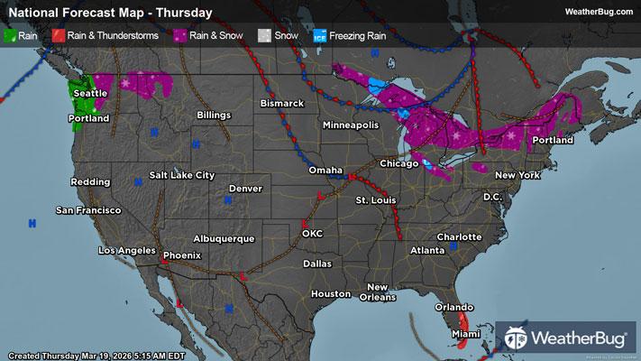
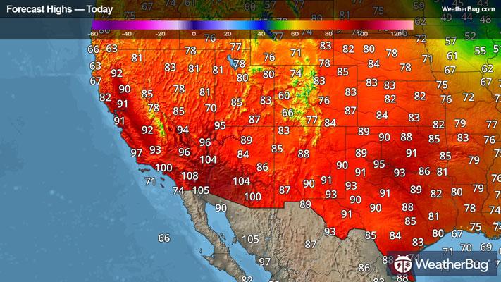
GroundTruthWeatherBug for Advertisers
  • Sign In
  • Press
  • Education
  • Feedback
  • Careers
  • Settings
  • Forecasts
  • Maps
  • Alerts
  • Life
  • News & Videos
  • Cameras
  • Air Quality
  • Hurricane
0
NowHourly10 Day
  • Today's Weather - Hanover, NH

    Jun 02, 2025 5:45 PM
    Hartford Fire Dept
    68°
    Weather forecast icon
    Feels like 68°
    Hi 69°F
    Lo 46°F
    Partly Cloudy
  • WEATHER DETAILSHanover, NH
    • Windchill60°F
      Daily Rain0"
    • Dew Point38°F
      Monthly Rain6.89"
    • Humidity44%
      Avg. WindWNW 1 mph
    • Pressure29.95"
      Wind Gust4 mph
    • Sunrise5:09 AM
      MoonFirst Quarter
    • Sunset8:24 PM
      UV Index7 (High)
  • WEATHER FORECASTHanover, NH
    TodayHi 68°F
    Weather forecast icon
    Partly cloudy with a chance of rain. Chance of precipitation 55%. High temperature around 68F. Dew point will be around 40F with an average humidity of 65%. Winds will be 6 mph from the W.
    TonightLo 44°F
    Partly cloudy this evening then clearing. Lows around 40. West winds around 10 mph this evening becoming light and variable.
  • Featured Videos
    Bison Calf Stays Close to Mom at Park
  • Air QualityHanover, NH
    -- | --
    Top Triggers: --
    Air quality data provided by Ambee
  • POLLEN COUNT & ALLERGY FORECASTHanover, NH
    ic_pollen_web
    Data not available for this location.
  • Lightning MapHanover, NH
    Closest strike in the last 30 minutes: -- away
    • TOP STORIES
      Potent Thunderstorms Eye Nation's Midsection
      Much of the Plains could experience severe weather today, whether it’s gusty winds, hail or an isolated tornado.

      A surface low pressure system and its associated cold front will advance through the Plains today. Moderate upper-level energy aloft will also contribute to the severe weather threat in addition to warm temperatures and plenty of moisture. 

      The Storm Prediction Center has highlighted southeastern South Dakota, far southwestern Minnesota, far northwestern Iowa, Nebraska, far southeastern Wyoming, and far eastern Colorado with a Slight Risk, including Cheyenne, Wyo., McCook, Grand Island and Norfolk, Neb., Colby, Kan., Amarillo, Texas, and Sioux Falls, S.D. An Enhanced Risk covers western Kansas, western Oklahoma, and the Texas panhandle. Garden City and Dodge City, Kan., Guymon, Okla., and Perryton, Texas, are included.

      Thunderstorms will develop and multiply this evening, lasting through the overnight hours. Hail up to golf ball size, as well as strong wind gusts exceeding 55 mph will be the main concern across the threat area, but an isolated tornado will be possible from northeastern Colorado to far southwestern Minnesota.

      A Severe Thunderstorm Watch is in effect for the Texas and Oklahoma panhandles, including Guymon, Okla., and Amarillo and Lubbock, Texas. Severe Thunderstorm Watches have been issued for central and north-central Minnesota and from northeastern Colorado and southeastern Wyoming to the Nebraska panhandle. This includes St. Cloud, Minn., Cheyenne, Wyo., and Sidney and Scottsbluff, Neb.

      This system’s cold front will later advance and bring additional severe weather concerns from central Texas northeast to southwestern Wisconsin Tuesday afternoon and evening. 

      The Storm Prediction Center already has a Slight Risk in place here, which includes Abilene and Fort Worth, Texas, Tulsa and Oklahoma City, Okla., Kansas City and Joplin, Mo., and Davenport, Ill. Hail as large as golf balls as well as strong wind gusts exceeding 55 mph will be the main concern across the threat area. Isolated tornadoes may also occur from north-central Texas northeast to southern Wisconsin.
        
      Make sure to know the difference between a watch and a warning should they be issued. A “watch” means that conditions are favorable for severe weather to occur and to be on alert for any rapidly changing conditions. A “warning” means that severe weather is imminent, and you should act fast to remain safe.

      The best way to remain safe is to stay prepared and informed about your local weather. Have a severe weather kit packed with a battery-operated radio, water, and non-perishable food items. Also, check the WeatherBug app frequently for any updates on today's severe weather. Remember, "When Thunder Roars, Go Indoors!"
      Read More
      Tuesday's Weather Outlook
      Read More
      Flash Flooding and Thunderstorms -- A Deadly Combination
      Read More
      Preparing for the Start of Hurricane Season
      Read More
      Soggy Weather, Drought Relief Seen Nationwide Except West
      Read More
      What is the Air Quality Index (AQI)?
      Read More
      MORE NEWS
      • TODAY'S NATIONAL OUTLOOK
      • Hurricane TrackerHanover, NH
        No Active Hurricanes or Warnings Issued
      • Allergy ForecastHanover, NH
        • Cold & FluHanover, NH
        • Snow & Ski ForecastHanover, NH
    • Fire Updates
      Hanover, NH
      Local Fire Map
    • Traffic Cameras
      Hanover, NH
    • Weather Cameras
      Hanover, NH
      No Weather Cams available in this region
    • Outdoor Sports GuideHanover, NH
Always Have Access to WeatherBug at Your Fingertips, It's Free.
Connect With Us
© GroundTruth, 2025. WeatherBug is a brand of GroundTruth. All Rights Reserved. Terms | Privacy | Partners | Ad Choices | Sitemap | USA | FAQ | WeatherBug for Advertisers
  • North America
  • South America
  • Africa
  • Europe
  • Asia
  • Australia