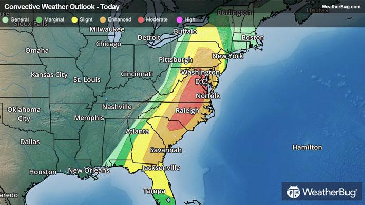
Dangerous Storms Take Aim At The Eastern U.S.
After more than 400 reports of severe weather on Sunday, a greater risk of dangerous thunderstorms exists today.
Read More
Weather Station:WeatherBug
18degrees Fahrenheit
Feels like:0
Hi: 18Lo: 8
Frozen Mix
Hi18°F
Very windy. Colder. Snow. Significant blowing and drifting snow. Snow may be heavy at times in the morning. Snow accumulation of 6 to 7 inches. Nearly steady temperature around 19. Northwest wind 30 to 40 mph with gusts to around 50 mph. Chance of snow near 100 percent.
Lo8°F
Blustery. Colder. Mostly cloudy in the evening then clearing. Some blowing and drifting snow in the evening. Lows zero to 5 above. Northwest wind 15 to 25 mph with gusts to around 40 mph decreasing to 10 to 15 mph after midnight. Lowest wind chill readings to 15 below zero after midnight.

23 | Fair
0.5 Low
Closest strike in the last 30 minutes:652.8 miles
No Lightning Nearby


