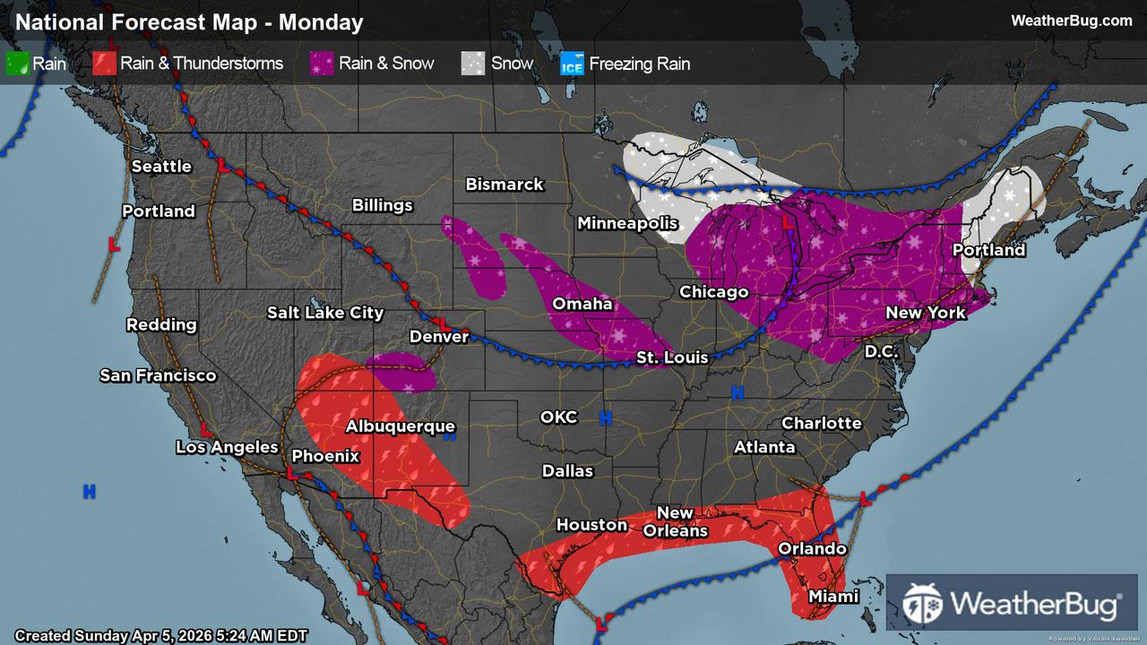
Merton, WI Weather

As of

Weather Station:WeatherBug

Open weather station selector modal

21degrees Fahrenheit

Feels like:7°F

Hi: --Lo: 20

Snow

Live Weather Radar

Merton, WI weather radar map

Current Weather Details

Windchill
Daily Rain
--"
Dew point
18°
Monthly Rain
1.15"
Humidity
90%
Avg. Wind
NNW 16 mph
Pressure
--"
Wind Gust
-- mph
Sunrise
7:04 AM
Moon
Waning Crescent
Sunset
7:00 PM
UV Index
3 (Moderate)

Weather Forecast

  • Tonight

    Lo

    Windy snow. Blowing snow. Snow may be heavy at times. New snow accumulation around 3 inches. Northwest winds 25 to 30 mph with gusts to around 45 mph. Chance of snow near 100 percent.

  • Tomorrow

    Hi

    Colder windy. Snow until late afternoon then chance of light snow late in the afternoon. Blowing snow until late afternoon then patchy blowing snow late in the afternoon. Snow may be heavy at times in the morning. Visibility one quarter mile or less at times in the morning. Snow accumulation of 2 to 4 inches. Total snow accumulation 5 to 8 inches. Near steady temperature around 20. Northwest winds 20 to 35 mph. Chance of snow near 100 percent.

Merton, WI 10-day weather forecast

AIR QUALITY

25 | Fair

Top Triggers:pm25
Air quality data provided by Ambee
View Today's Air Quality details for Merton, WI

POLLEN COUNT & ALLERGY FORECAST

0.6 Low

Predominant Pollen:Cedar/Juniper
View the Pollen forecast details

LIGHTNING MAP

Closest strike in the last 30 minutes:591.7 miles

No Lightning Nearby

Real-time lightning alerts & live Map