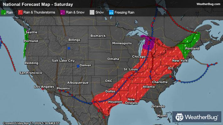
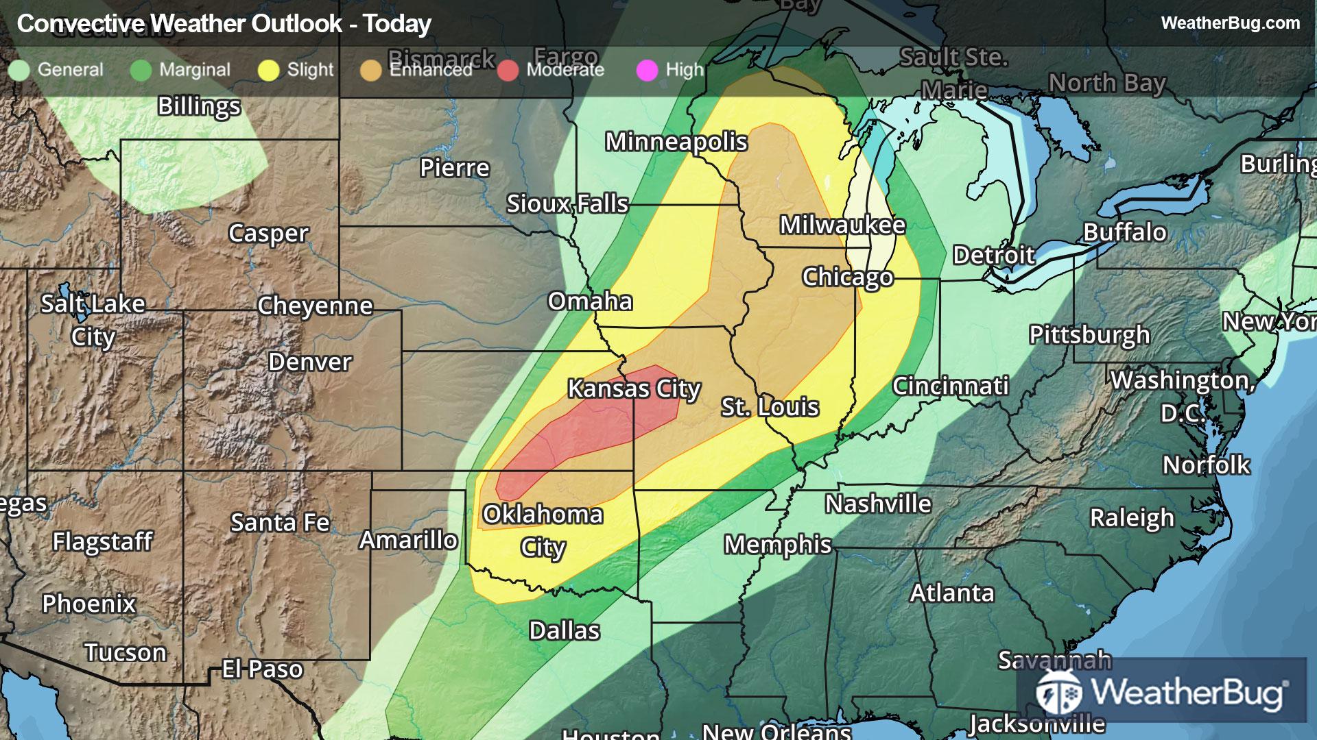
GroundTruthWeatherBug for Advertisers
  • Sign In
  • Press
  • Education
  • Feedback
  • Careers
  • Settings
  • Forecasts
  • Maps
  • Alerts
  • Life
  • News & Videos
  • Cameras
  • Air Quality
  • Hurricane
1
NowHourly10 Day
  • Today's Weather - Nacogdoches, TX

    Jul 27, 2025 7:59 AM
    NACOGDOCHES
    82°
    Weather forecast icon
    Feels like 90°
    Hi 91°F
    Lo 74°F
    Partly Cloudy
  • WEATHER DETAILSNacogdoches, TX
    • Windchill82°F
      Daily Rain--
    • Dew Point77°F
      Monthly Rain3.4"
    • Humidity87%
      Avg. WindS 4 mph
    • Pressure--
      Wind Gust--
    • Sunrise6:31 AM
      MoonWaxing Crescent
    • Sunset8:18 PM
      UV Index11 (Extreme)
  • WEATHER FORECASTNacogdoches, TX
    TodayHi 91°F
    Weather forecast icon
    Mostly cloudy early then partly cloudy with a slight chance of showers and thunderstorms this afternoon. Humid with highs in the lower 90s. South winds around 5 mph. Chance of rain 20 percent. Heat index values up to 107.
    TonightLo 74°F
    Mostly clear. Humid with lows in the lower 70s. South winds around 5 mph in the evening becoming light and variable.
  • Featured Videos
  • Air QualityNacogdoches, TX
    -- | --
    Top Triggers: --
    Air quality data provided by Ambee
  • POLLEN COUNT & ALLERGY FORECASTNacogdoches, TX
    ic_pollen_web
    Data not available for this location.
  • Lightning MapNacogdoches, TX
    Closest strike in the last 30 minutes: -- away
    • TOP STORIES
      Rounds of Severe Weather Take Aim At North-Central U.S.
      The end of July will go out with a bang as multiple rounds of severe weather target the northern Plains and Upper Mississippi Valley.

      An upper-level weather system and associated cold front will drop south into the north-central U.S. today. Very warm, humid air will be in place ahead of the front, while cooler and drier air attempts to stream in behind it. This collision of air masses will cause thunderstorms to bubble up in the northern Plains and Upper Mississippi Valley this afternoon and evening. As they move south and east, these storms will likely strengthen, quickly turning strong to severe.

      The government’s Storm Prediction Center has issued a Slight Risk for severe weather today. This covers most of Minnesota into northern Wisconsin and Michigan’s Upper Peninsula, including Minneapolis and Duluth, Minn. The main concern within thunderstorms here would be damaging winds exceeding 60 mph, large hail and torrential downpours. However, an isolated tornado or two cannot be ruled out.

      However, anyone in the northern Plains and Upper Mississippi Valley should keep a close eye on rapidly changing weather. Gusty winds and small hail could still be a possibility for places like Glasgow, Mont., Minot and Grand Forks, N.D., Des Moines, Iowa, La Crosse and Green Bay, Wis., and Marquette, Mich.

      The same cold front will inch south and east across the north-central U.S. on Monday. This will keep the threat of severe weather in the northern Plains and Upper Mississippi Valley.

      Make sure to know the difference between a watch and a warning should they become issued. A watch means that conditions are favorable for severe weather to occur and to be on alert for any rapidly changing conditions. A warning means that severe weather is imminent, and you should act fast to remain safe.

      The best way to remain safe is to stay prepared and informed about your local weather. Have a severe weather kit packed with a battery-operated radio, water and non-perishable food items should you be without power for long periods of time. Also, check the WeatherBug app frequently for any updates on today’s severe weather. Remember, “When Thunder Roars, Go Indoors!”
      Read More
      Major Heatwave Set to Broil Eastern Two-Thirds of U.S.
      Read More
      Today's Weather Outlook
      Read More
      Heat-Related Alerts: Sizzling Differences
      Read More
      How Do Wildfires Start and Spread?
      Read More
      How to Stay Cool When There's No A.C.
      Read More
      MORE NEWS
      • TODAY'S NATIONAL OUTLOOK
      • Hurricane TrackerNacogdoches, TX
        No Active Hurricanes or Warnings Issued
      • Allergy ForecastNacogdoches, TX
        • Cold & FluNacogdoches, TX
        • Snow & Ski ForecastNacogdoches, TX
    • Fire Updates
      Nacogdoches, TX
      Local Fire Map
    • Traffic Cameras
      Nacogdoches, TX
    • Weather Cameras
      Nacogdoches, TX
      No Weather Cams available in this region
    • Outdoor Sports GuideNacogdoches, TX
Always Have Access to WeatherBug at Your Fingertips, It's Free.
Connect With Us
© GroundTruth, 2025. WeatherBug is a brand of GroundTruth. All Rights Reserved. Terms | Privacy | Partners | Ad Choices | Sitemap | USA | FAQ | WeatherBug for Advertisers
  • Alabama
  • Alaska
  • Arizona
  • Arkansas
  • California
  • Colorado
  • Connecticut
  • Delaware
  • Florida
  • Georgia
  • Hawaii
  • Idaho
  • Illinois
  • Indiana
  • Iowa
  • Kansas
  • Kentucky
  • Louisiana
  • Maine
  • Maryland
  • Massachusetts
  • Michigan
  • Minnesota
  • Mississippi
  • Missouri
  • Montana
  • Nebraska
  • Nevada
  • New Hampshire
  • New Jersey
  • New Mexico
  • New York
  • North Carolina
  • North Dakota
  • Ohio
  • Oklahoma
  • Oregon
  • Pennsylvania
  • Rhode Island
  • South Carolina
  • South Dakota
  • Tennessee
  • Texas
  • Utah
  • Vermont
  • Virginia
  • Washington
  • West Virginia
  • Wisconsin
  • Wyoming
  • North America
  • South America
  • Africa
  • Europe
  • Asia
  • Australia