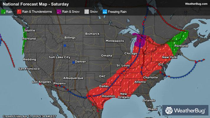
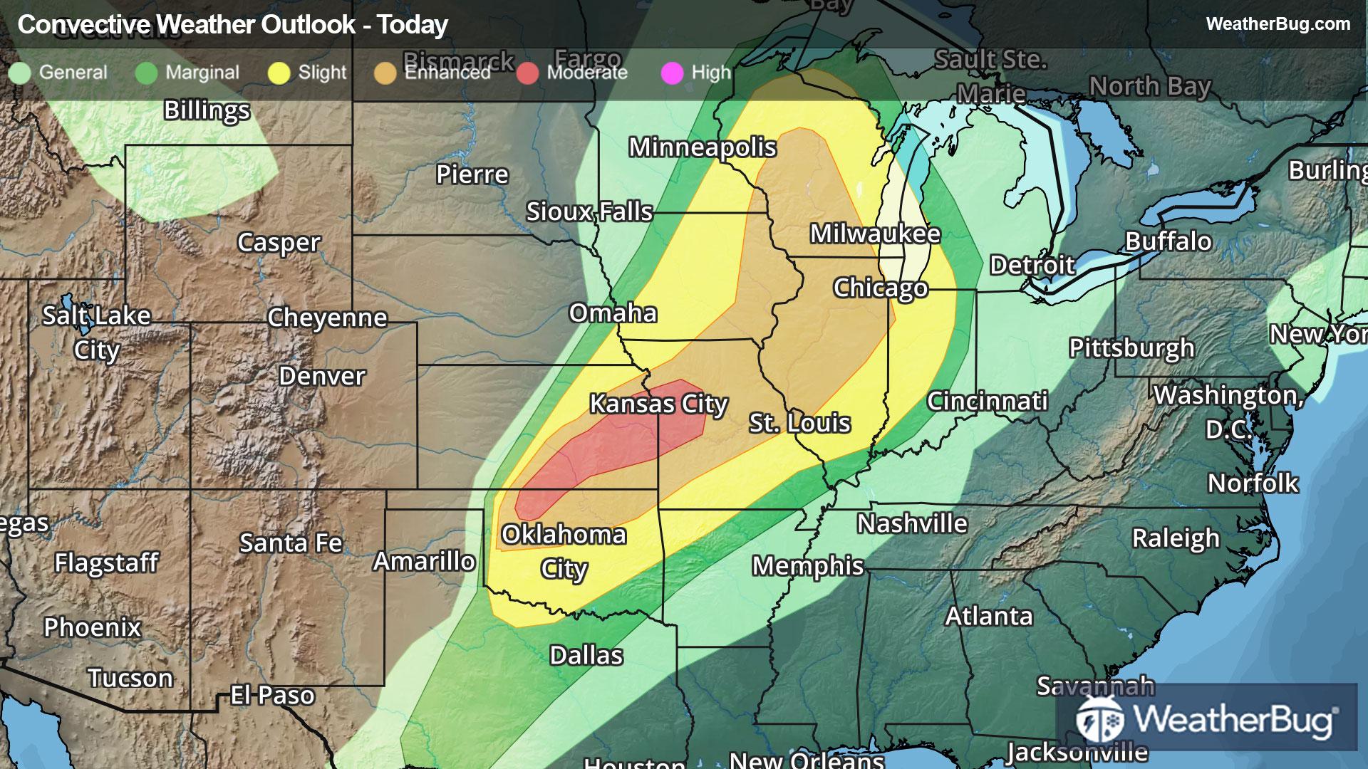
GroundTruthWeatherBug for Advertisers
  • Sign In
  • Press
  • Education
  • Feedback
  • Careers
  • Settings
  • Forecasts
  • Maps
  • Alerts
  • Life
  • News & Videos
  • Cameras
  • Air Quality
  • Hurricane
0
NowHourly10 Day
  • Today's Weather - New Ulm, TX

    May 30, 2025 10:20 PM
    Fayetteville ISD
    74°
    Weather forecast icon
    Feels like 74°
    Hi --
    Lo 69°F
    Partly Cloudy
  • WEATHER DETAILSNew Ulm, TX
    • Windchill74°F
      Daily Rain0.3"
    • Dew Point72°F
      Monthly Rain5.48"
    • Humidity91%
      Avg. WindNW 1 mph
    • Pressure29.86"
      Wind Gust1 mph
    • Sunrise6:26 AM
      MoonWaxing Crescent
    • Sunset8:21 PM
      UV Index10 (Very High)
  • WEATHER FORECASTNew Ulm, TX
    TonightLo 70°F
    Weather forecast icon
    Mostly cloudy. Lows in the lower 70s. North winds 5 to 10 mph.
    TomorrowHi 86°F
    Partly sunny. Highs in the upper 80s. North winds around 5 mph.
  • Failed to load
    Something went wrong loading the data.
    Please reload the page or try again later.
  • Air QualityNew Ulm, TX
    -- | --
    Top Triggers: --
    Air quality data provided by Ambee
  • POLLEN COUNT & ALLERGY FORECASTNew Ulm, TX
    ic_pollen_web
    Data not available for this location.
  • Lightning MapNew Ulm, TX
    Closest strike in the last 30 minutes: -- away
    • TOP STORIES
      Severe Storm, Flooding Batter East
      Severe weather and flooding will linger across part of the eastern U.S. this evening.
       
      A disturbance and its cold front will continue to push through the Mid-Atlantic during the evening hours. Along and, and with an unstable atmosphere present, thunderstorms will erupt, some of which will turn severe.
       
      Areas from Trenton, N.J. and Philadelphia to Baltimore southward to Richmond will need to watch for severe weather this evening as the government’s Storm Prediction Center has issued a Slight Risk, or a 2 out of 5 on the severe weather probability scale, for these areas.
       
      Damaging wind gusts in excess of 60 mph and quarter-sized hail will be the primary threats from thunderstorms this evening. However, an isolated tornado or two cannot be ruled out, especially across portions of central and southern Virginia into north-central North Carolina.

      A Tornado Watch remains across the Mid-Atlantic from Maryland to the Atlantic coast. 
        
      In addition to the storms, locally heavy rainfall will accompany this front across portions of the Mid-Atlantic. Rain totals up to 2 inches will be possible from northern Virginia to northern New Jersey. A few unlucky locations could see rain amounts of 3-4 inches, with localized instances of urban flooding. As such, a Flood Watch is in effect from this evening into tonight. Remember, if you approach a flooded roadway, it is always best to “Turn Around, Don’t Drown!”
       
      Strong to locally severe storms will remain possible across parts of the Mid-Atlantic into the Carolinas on Saturday. Small hail and gusty winds will be the main threats on Saturday. A few gusty thunderstorms will also be possible across Florida on Saturday as a cold front sinks southward.
       
      Make sure to know the difference between a watch and a warning should they become issued. A “watch” means that conditions are favorable for severe weather to occur and to be on alert for any rapidly changing conditions. A “warning” means that severe weather is imminent, and you should act fast to remain safe.

      The best way to remain safe is to stay prepared and informed about your local weather. Have a severe weather kit packed with a battery-operated radio, water, and non-perishable food items should you be without power for long periods of time. Also, check the WeatherBug app frequently for any updates on today's severe weather. Remember, "When Thunder Roars, Go Indoors!"
      Read More
      Weekend Weather Outlook
      Read More
      Flash Flooding and Thunderstorms -- A Deadly Combination
      Read More
      Soggy Weather, Drought Relief Seen Nationwide Except West
      Read More
      Summer Heat Safety: Defining Heat Waves
      Read More
      Tornado Statistics By State
      Read More
      MORE NEWS
      • TODAY'S NATIONAL OUTLOOK
      • Hurricane TrackerNew Ulm, TX
        No Active Hurricanes or Warnings Issued
      • Allergy ForecastNew Ulm, TX
        • Cold & FluNew Ulm, TX
        • Snow & Ski ForecastNew Ulm, TX
    • Fire Updates
      New Ulm, TX
      Local Fire Map
    • Traffic Cameras
      New Ulm, TX
    • Weather Cameras
      New Ulm, TX
      No Weather Cams available in this region
    • Outdoor Sports GuideNew Ulm, TX
Always Have Access to WeatherBug at Your Fingertips, It's Free.
Connect With Us
© GroundTruth, 2025. WeatherBug is a brand of GroundTruth. All Rights Reserved. Terms | Privacy | Partners | Ad Choices | Sitemap | USA | FAQ | WeatherBug for Advertisers
  • Alabama
  • Alaska
  • Arizona
  • Arkansas
  • California
  • Colorado
  • Connecticut
  • Delaware
  • Florida
  • Georgia
  • Hawaii
  • Idaho
  • Illinois
  • Indiana
  • Iowa
  • Kansas
  • Kentucky
  • Louisiana
  • Maine
  • Maryland
  • Massachusetts
  • Michigan
  • Minnesota
  • Mississippi
  • Missouri
  • Montana
  • Nebraska
  • Nevada
  • New Hampshire
  • New Jersey
  • New Mexico
  • New York
  • North Carolina
  • North Dakota
  • Ohio
  • Oklahoma
  • Oregon
  • Pennsylvania
  • Rhode Island
  • South Carolina
  • South Dakota
  • Tennessee
  • Texas
  • Utah
  • Vermont
  • Virginia
  • Washington
  • West Virginia
  • Wisconsin
  • Wyoming
  • North America
  • South America
  • Africa
  • Europe
  • Asia
  • Australia