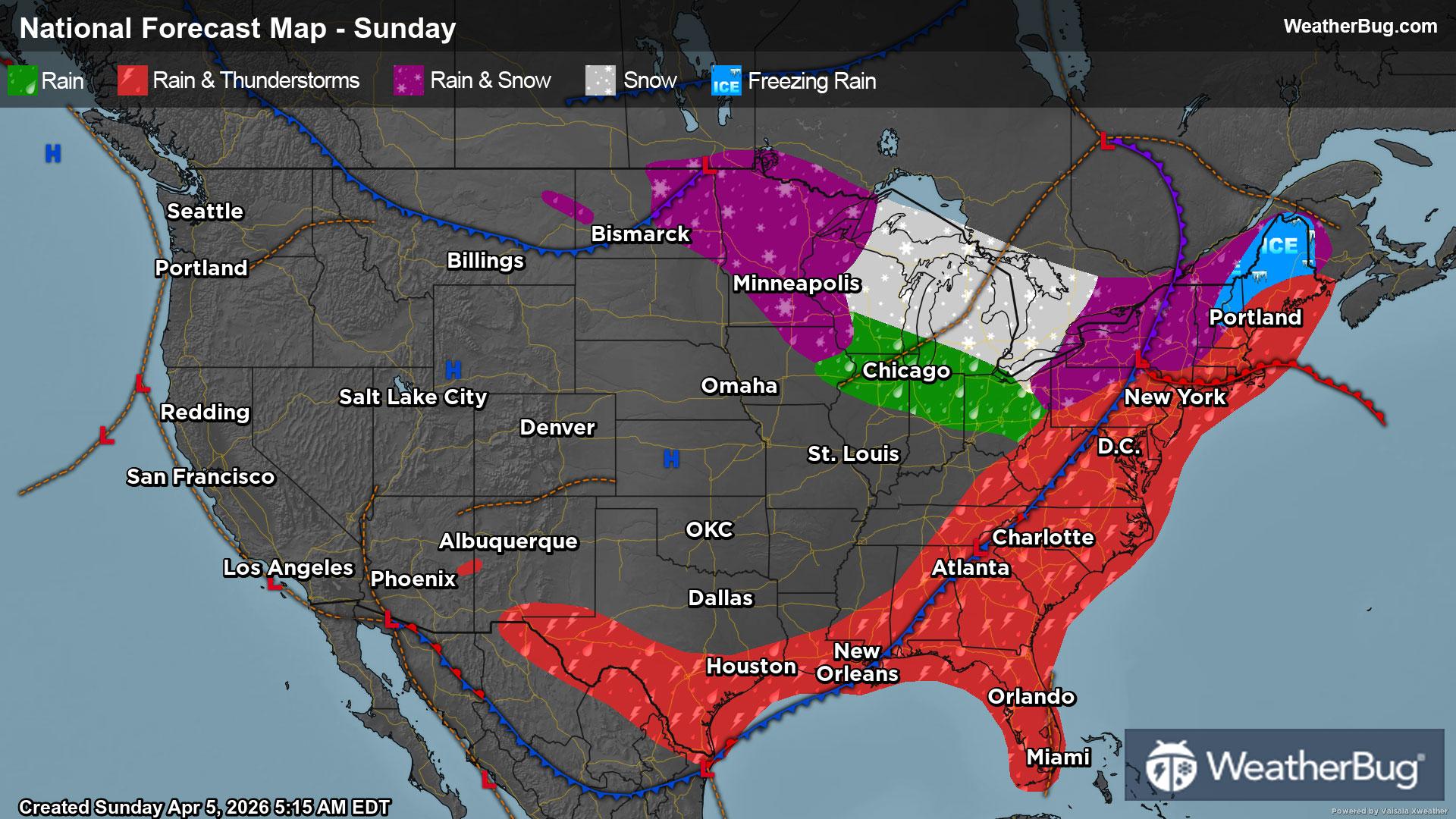
North Prairie, WI Weather

As of

Weather Station:East Troy Municipal Arpt

Open weather station selector modal

27degrees Fahrenheit

Feels like:18°F

Hi: 38Lo: 20

80% Chance Freezing Rain

Live Weather Radar

North Prairie, WI weather radar map

Current Weather Details

Windchill
18°
Daily Rain
1.04"
Dew point
26°
Monthly Rain
1.15"
Humidity
94%
Avg. Wind
N 10 mph
Pressure
29.36" →
Wind Gust
25 mph
Sunrise
7:06 AM
Moon
Waning Crescent
Sunset
6:59 PM
UV Index
1 (Low)

Weather Forecast

  • Tonight

    Lo

    Colder windy. Areas of blowing snow until early morning. Blowing snow early in the morning. Light sleet in the evening. Freezing rain through around midnight. Snow through the night. Snow and sleet accumulation of 2 to 5 inches. Ice accumulation of less than one quarter of an inch. Lows around 18. North winds 20 to 30 mph with gusts to around 45 mph. Chance of precipitation near 100 percent.

  • Tomorrow

    Hi

    Colder windy. Light snow until late afternoon then chance of light snow late in the afternoon. Blowing snow until late afternoon then patchy blowing snow late in the afternoon. Visibility one quarter mile or less at times in the morning. Snow accumulation of 1 to 2 inches. Total snow accumulation 4 to 7 inches. Near steady temperature around 19. Northwest winds 20 to 35 mph. Chance of snow near 100 percent.

North Prairie, WI 10-day weather forecast

AIR QUALITY

23 | Fair

Top Triggers:pm25
Air quality data provided by Ambee
View Today's Air Quality details for North Prairie, WI

POLLEN COUNT & ALLERGY FORECAST

0.4 Low

Predominant Pollen:Cedar/Juniper
View the Pollen forecast details

LIGHTNING MAP

Closest strike in the last 30 minutes:280.2 miles

No Lightning Nearby

Real-time lightning alerts & live Map