
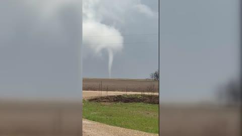
Today's Weather Outlook
Cooler, spring-like weather moves through the Eastern U.S. as much-needed rain drifts into the West Coast.
Read More
Weather Station:IRON MOUNTAIN
35degrees Fahrenheit
Feels like:29°F
Hi: 48Lo: 35
Sunny
Hi46°F
Sunny this morning then becoming partly cloudy. Warmer with highs around 50. Southwest winds 5 to 10 mph becoming south 10 to 15 mph with gusts up to 25 mph this afternoon.
Lo35°F
Mostly cloudy in the evening then clearing. Lows around 35. South winds 5 to 15 mph with gusts up to 25 mph.
21 | Fair
9.3 Medium-High
Closest strike in the last 30 minutes:1220.9 miles
No Lightning Nearby


